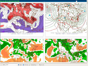
Through the middle of this week rather quiet and near seasonable weather will prevail across interior NY State and western New England. Temperatures both day and night should average close to normal. High pressure and dry weather are expected through Wednesday.
Beginning Thursday the weather pattern looks like it be taking a turn toward a more active and stormy scenario.
As is often the case this time of year cold air tends to "pool" over the still frozen and near frozen Hudson and James Bay regions of Canada. During Spring and even into early summer (even though the ice and snow is long gone from these bays by then they remain cold), the bays become a source region for polar air and the development of chilly high pressure systems. These highs often press southward across Ontario and Quebec Provinces as well as across NY State and New England.
Such will be the case on Thursday when a strong polar high builds south from southeast Canada across the Northeast States.
Beyond Thursday into Friday of this week is when the turn to increased storminess is forecast especially over the East Coast of the US. Most long range models are indicating amplification of the flow aloft across the Lower 48 resulting in a developing ridge across the Western U.S. and a deepening trough over the Eastern U.S.
Below is the upper-air forecast from the GFS 27 March 2011 0600 GMT run of the GFS for this Friday afternoon April 1st for 1800 GMT (2PM). Out west the ridge is in a favorable location and of good amplitude while the trough in the East is also forecast to be a major amplitude too (long with a cut-off low pressure system embedded in it over Ohio).
At the surface (map below forecast for same date and time) an area of low pressure is forecast over western Lake Erie with a second low near Washington, D.C. over the northern Chesapeake Bay.
Similarly is the forecast data from last night's UKMET model run for Friday evening April the 2nd. The forecast 500 millibar pattern is the map on the left and the surface forecast is on the right:
Then there is the EC model from 00Z last night (27 March):
In general ALL of the 3 models have a somewhat similar scenario forecast over the Lower 48. The EC has the weakest and somewhat more progressive ridge out west vs. the GFS and UK. The UK is the most intense forecast surface and aloft. The GFS somehwat "in-between" the UK and EC on the intensity of the upper-air and surface features.
Which solution will win out remains to be seen. Some caveats: the EC has been showing some continuity issues over the past 3 days. The GFS operational run does have some support from its ensembles. While the UK IS the most intense solution, it has been consistent on this scenario for the past 1-2 days; also the UK tends to do quite well with Eastern U.S. cut-off lows during the Spring.
For now this forecaster's take is to use a 2/3rds UK/GFS, 1/3rd blend EC for next Friday's system. The track of the low looks to lie between the UK and EC (actually close to the EC ensemble mean).
Thus this means that there exists the potential for an early Spring snow storm across the Northeast U.S. Expect the snow fall to be tied to the following factors: intensity of precipitation, time of day and elevation. As of now I think the Poconos and southern Catskills could be the prime locations for a heavy wet snowfall.
Of course this is subject to change. Until my next update all the best!


No comments:
Post a Comment
Thank you for taking the time to comment, I will answer as soon as I can.