Before I get into fronts. I want to briefly mention the types of air masses:
An air mass is a very large body of air with similar temperature and moisture characteristics. Air masses are placed in categories based on the region where it has been over long enough to pickup the temperature and moisture characteristics of that region. Air masses don’t just sit in one place, they move around. Because of this they have to be classified. Air masses over the ocean are loaded with moisture and continental air masses are much drier. Maritime and continental air masses can be warm or cold.
Air masses are labeled with a two letter classification system. The letters are based on the point of origin (source region) of the air mass.
The first letter indicates the moisture characteristics. m for Maritime, this type of air mass is normally moist and mild. c for continental, this type of air mass is drier and tend to be influenced more by daytime heating and nighttime cooling.
The second letter indicates the moisture characteristics. The letters are:
E (equatorial and hot)
T (tropical and hot)
P (polar the temp can very from warm to cold)
A (arctic which is very cold )

Here is a image from Meted.edu. it shows the types of air masses that effect the weather patterns over North America.
The Continental Arctic (cA) and Continental Polar (cP) over Alaska and Canada. often move south and have a dynamic effect on the weather in the continental US. For example during the Winter when those type of air masses move over the Great Lakes they kick off lake effect snow storms
A third letter is sometimes used to identify how stable the air mass is. The temperature of the air mass is compared to the surface temperature of the region, the air mass is moving over. If the air mass is warmer that the surface temperature the lower case w is added to the air mass descripion. If the air mass is cooler it is giving the lower case k. A cold air mass flowing away from its source region over a warmer surface will be warmed from below. This will make the air mass more unstable in the lower levels of the atmosphere. A warm air mass moving over a cooler surface will be cooled from below and becomes stable.
What is a weather front (From here on I will just be calling it a front):
A front is the transition zone (boundary) between air masses of different temperatures and densities. The zone of transition is also called a frontal zone. The type of front depends on which direction the air mass is moving along with the characteristics of the air mass. A frontal zone can be 20 miles wide or it can be over a 100 miles wide.. The frontal zone represents the leading edge of wedge of cool /cold air. if this wedge is moving into a warm air mass it’s called a cold front. but if the colder air retreating and warmer air is taking it’s place, then it’s a warm front.
The types of fronts:

Warm front: is a front that is replacing cooler air at the surface with warmer air. While the passage of a warm front can kick off thunderstorms, normally a warm front is associated with calm and tranquil weather.

Cold front: is a front that is replacing warmer air at the surface with cooler air. typically cold fronts move faster than warm fronts. Normally a cold front is associated with stormily weather

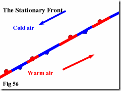
This image of a stationary front came from Keithrogershome.com. As the name implies, it’s a front that doesn’t move or moves extremely slow. The winds along the frontal zone are parallel to the front.
 Occluded front, because cold fronts move faster than warm fronts, they overtake the warm front ahead of them.
 When cold front catches up to a warm front and lifts the warm front over a dome of very cold air, it’s called a cold occlusion.
When the air behind a cold front is warmer that the air in front of it (isn't dense enough to lift the warm front ahead of it), The cold front will climb over the top of the warm front , this is called a warm occlusion.

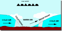
On a chart or map, a cold front is represented by a solid blue line, with triangles along it.
A warm front is represented by a solid red line, with semicircles along it.
A stationary front is represented by an alternating red / blue line with semicircles on one side and triangles on the other side.
A Occluded front is represented by a solid line, with the semicircles and triangles on the same side.
Image is from Okfirst.mesonet
The two types of cold fronts:
All cold fronts mean a drop in temperature is on it’s way. However, how much precipitation falls when it passes overhead can vary. Most cold fronts preceded by a shield of rain, However, some of them drop very little. In fact, sometimes the only way you can tell a cold front as passed, is when the temperature drops and the winds change direction. The names for these two types of cold fronts are called Anafronts and katafronts.
Anafront, is normally a cold front, that is a heavy precipitation maker. A anafront occurs when a front advances faster that the flow in which it is embedded. Because of this, a cold front in New England can be producing a snowstorm in New York State.

The word Ana means to ascend. So in the case of an anafront; the warm moist air is rising. The warm moist air will rise over the lower edge of the cold front. When this happens it creates clouds and precipitation behind the actual cold front.
Katafront, This type of front is normally associated with little or no precipitation. The Katafront is one where the the flow of the frontal zone is faster than the speed of the front. The flow is also downward. Because the flow is downward it compresses and warms the surface air, which leads to evaporation of the moisture needed to make precipitation.

This results in a long, narrow band of precipitation. Most of the precipitation occurs ahead of a katafront. The warm moist air can’t rise high enough to stir things up, storms have a very difficult time forming.
Isobaric Analysis, you should be able to identify the lines showing the fronts. The other lines are called isobars and depict the areas that have the same corrected sea level barometric pressure.

Here is the surface chart for October 9th 2012. You should be able to identify the lines showing the different types of fronts. The other lines are called isobars and depict the areas that have the same corrected sea level barometric pressure. The isobar spacing is at 4 mb intervals, centered on 1000mb. The H’s and L’s indicate areas of high pressure or low pressure. If the trough of low pressure has a lot of rain or wind associalted with it; the area can sometimes be seen as a thick brown dashed line.
It is my hope that this brief lesson will give you enough knowledge to have an idea what you're looking at on a surface chart.
Rebecca

No comments:
Post a Comment
Thank you for taking the time to comment, I will answer as soon as I can.