The El Nino Southern Oscillation deals with
the fluctuations in the Sea Surface temperature
(SST) in the equatorial Pacific. It has two phases, El Nino the warm positive
phase, La Nina the cool negative phase.
The
El Nino is getting impressive... I must admit... it is getting stronger than I
said it would....You can't win them all.
We've
had strong El Nino's before. 1972-1973,
1982-1983, 1997-1998. The strongest on record was the 1997 El Nino. Right now,
our current El Nino looks to be just a bit weaker than 1997...but all the July
readings aren't in yet.
In
my Facebook weather group, I've fielded questions and discussed on the current El
Nino.
During an
El Nino, the southern jet stream comes farther north. This allows for a better
chance for phasing the northern and southern Jet streams. Phasing is when a disturbance
in the northern jet and a disturbance in the southern jet merges and becomes
one very powerful storm. When we have a
very strong El Nino the southern Jet is even farther north. Last year we had a
very positive (warm) Pacific Decadal Osculation (PDO). The PDO promoted ridging over the
western Continuous United States ( CONUS)
and troughing over the eastern CONUS. This allowed more cold air to come down
out of Northwestern Canada and Alaska. With the ENSO bringing the southern jet
closer to the northern jet. This is want happened during the winter of
2014-2015. We saw a lot of Nor'easters and major coastal storms.
1997 was a
extremely warm winter in the Northeast. The reason was in part because of the
strong El Nino. Here is a chart showing the SST. You can see the warmth in the tropical
Pacific look very similar.
I've
talked about on my Facebook weather pages....even though we have a very strong
El Nino, many other conditions in the Pacific and Atlantic are completely
different.
We
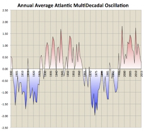
have a strong (PDO) and a negative Atlantic Multidecadal Osculation (AMO).
The
PDO was a little stronger a month ago... But since then, the PDO has seen some
weakening on its northern edge. Also, the
SST's around Australia and into the Indian Ocean are starting warm up. This
will aid the El Nino to get stronger. Six weeks ago the waters around Australia
were cooler. The fact that these SST are warming ...will give this El Nino issues. During the 1997 El Nino the waters around Australia were cooler. With that said, I know I was saying this El Nino would be moderate to strong....but I was wrong...it looks like this current El Nino will end up warmer than the El Nino of 1997.
El Nino
and La Nina are short term cycles..... whereas the PDO and AMO are long term
cycles.
Here are a
couple of charts that show the cycles.
We're in a
positive PDO and a negative AMO.... if you look at the top left (chart below) you will see
how things are matching up to what we would expect from that pattern.
When we
have a positive PDO, we tend to see more strong El Nino's, fewer hurricanes in
the Atlantic, and a less active tornado season.
When we
have a negative AMO, we tend to see strong LA Nina's, fewer hurricanes, and tendency
for a positive North Atlantic Osculation (NAO) and positive Atlantic Osculation
(AO).
Far too
many meteorologist rely and trust only weather models. Models are great tools,
but they are only part of what should be looked at. Looking at teleconnections,
sea ice, solar activity, and other things are is very important as well. I
based by Spring Summer outlook on all of these things. Just as I use them when I make a winter
outlook. If you've been following my post. Then how last winter turned
out...and how this year is turning out....should be no surprise.
For the
last few months I've been talking about the long range pattern; so far things
are going as I outlined. I've been
saying we will see cooling as we move into August, and things still seem to be trending that way. We
will stay in this transient weather pattern well into August. But as we head into the end of August and for
September, we will see more in the way of long lasting warming. The NCEP CFS V2 for August and September, show this to be the
case.
The NCEP CFS V2 :
August,
September,
As we head toward and get into the coming winter, the current teleconnection pattern of the PDO and AMO would indicate more in the way of cold..... So this year's El Nino shouldn't allow for the type of warm conditions we saw in 1997. The warm water near Australia would indicate on average higher pressure, with lower pressure on average in the tropical Pacific. This sort of setup would allow the warm water off the West Coast of South America to move more to the west, as we get closer to this coming winter.


No comments:
Post a Comment
Thank you for taking the time to comment, I will answer as soon as I can.