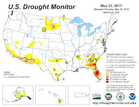
Last Summer, into December was dry across the Northeast and Mid Atlantic.
Here are a few images from U.S. Drought Monitor for 2016, that show how dry we
were.
The last 60-90 days has been wet across the eastern half of the CONUS.
Our drought in the Northeast has been erased. It has been replaced with
well above average precipitation this Spring.
Soil Moisture chart shows just how wet we are now compared to May of 2016.
From WeatherBELL
The next 2-3 months look to be a bit wet. Now given the landfall possibilities
I out laid in my hurricane outlook. The Northeast could end up with a tropical
system bringing a lot of rainfall. So there is a chance we could be very wet by
this Fall.
Climate Prediction Center:
Bit of house cleaning:
I've been asked many times, why don't I refer to or show the CPC three
month temperature and precipitation forecast outlooks?
My answer is they are not a true forecast. Instead they are based on a percentage
of the odds of probabilities. They are rated on an A,B,C score. A is above average, B is near normal and C is
Below normal. With EC meaning equal chance. For example
Forecast probability anomalies
OF 20%, 30% and 40% for above normal
imply probabilities for
all three classes (above, near, below)OF 53.3% - 33.3% - 13.3% --- 63.3% -
33.3% - 3.3% AND 73.3% - 23.3% - 3.3% respectively.
Here is the current CPC
three month outlook for temperature and precipitation.
Here is the chart I did
for my summer outlook. This is an actual forecast that can be verified.
Anyway back to my post.
I've been saying for
months, that this Summer will be a lot cooler than last Summer. I've been
saying average to slightly above average for temperatures. Looking at some of
the models we can see they are calling for the summer to be cool.
The next 6 weeks are forecast cooler on average in the EPS.
The CFS latest run has the nation cool.
From WeatherBELL
We have a + Atlantic Multidecadal Oscillation (AMO) and a + Pacific Decadal
Oscillation (PDO), this would explain at least in part, why the Spring has been
behaving like it has.
The Teleconnections are at odds on the ENSO. Many are backing off from the
chance for El Nino developing.
From Tropical Tidbits.
Looking at the surface temperature anomalies you can see how much colder (relative to average)
the Central to Northeastern CONUS has been.
Since the first of the year, Sea Surface Temperature Anomalies (SSTAs) have
warmed in the eastern tropical pacific, but cooled off in the Gulf Of Mexico (
GOM) and western Pacific and the central
Atlantic. While the northern Atlantic and
southern Pacific Ocean have warmed.
My estimate of the daily Nino 3.4 index is +0.7 which is a El Nino index
Value. On the other hand, NOAA has the weekly Nino 3.4 at +0.4, a neutral
value.
I still believe we're going to see a weak El Nino Modoki (central based), or negatively based ENSO,
this Fall going into the coming winter. If we do see a weak La Nina it would be east Based. If I'm right, we're going to see an
active and cold winter for 2017-2018.
This is how things have gone so far, and where things look to head for the next three months.
Well that's about it.
Well that's about it.


No comments:
Post a Comment
Thank you for taking the time to comment, I will answer as soon as I can.