The last couple of days, saw a couple of cold fronts move through, bringing rain and higher elevation snow showers as cold air moves in overhead.
Today isn’t
as raw as yesterday, but it is still quite chilly, with well below average
temperatures. There is an upper-level low overhead along with a few shortwave
troughs working through, which is making for a mix of sun and clouds with a few
scattered showers and mountain snow showers. Tonight is going to be another
cold night. Tomorrow will be similar to today, but the showers should be more
isolated.
Thursday
high pressure is going to start to nose in. There will be low pressure off the
Carolina Coast, but the high pressure should keep that suppressed to our south
and east. But it could be close enough for a few showers over Maryland, Delaware
and perhaps southern New Jersey. Everywhere else should be dry. Winds could be
a bit breezy, especially along the coast. Thursday will also see the start of a
warming trend. Friday through Tuesday the high pressure will provide plenty of
sun, dry conditions and seasonally mild conditions.
Tropical
outlook
We have
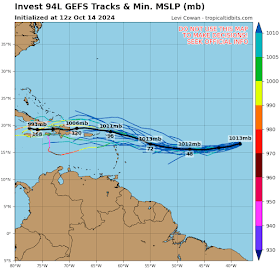
Invest 94 L out in the Mid Atlantic sitting between the Cabo Verde Islands and
the Lesser Antilles. It is moving west
to west-northwest and is looking heathy. The National Hurricane Center (NHC)
has the development odds at 30 and 60 percent the 2- and 7-day periods,
respectively.
The system
is experiencing light to moderate wind shear, but it is surrounded by dry air,
this should keep any development megger over the next couple of days. But as it
gets farther west, conditions will become more favorable for gradual
development, as it approaches the Leeward Islands later this week. There is a
chance this could try to track toward Florida.
But this track would send it into higher wind shear, making it very
difficult for it to become a big issue for the Peninsula.
The blob in
the Western Caribbean has a 30% chance for developing. The next names on the
list are Nadine and Oscar.


No comments:
Post a Comment
Thank you for taking the time to comment, I will answer as soon as I can.