
Temperatures peak today for some of us.


It's going to be another hot and muggy day as the southwest flow continues to push that tropical air mass into the region. The Canadian wildfire smoke shouldn't be as big of an issue as it has been the last couple days; as the southwest flow continues to push the smoke out of the region. But there could be enough to cause some hazy filtered sunshine and maybe some of the smoke could get down to the surface.

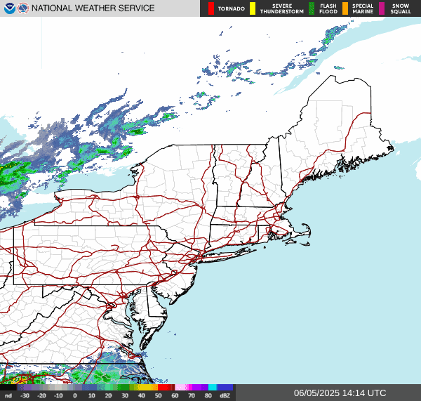
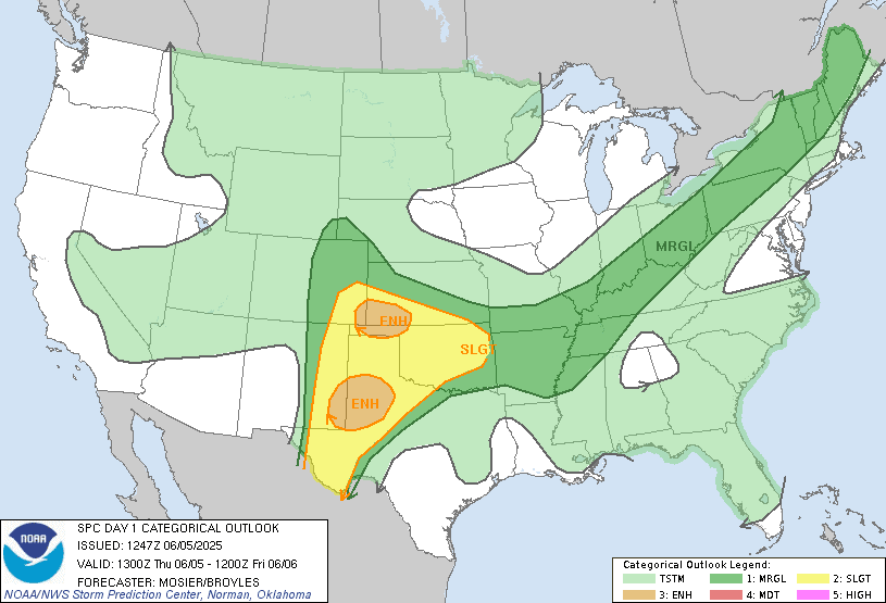
The surface chart shows the cold front crawling towards us. The front is starting to weaken a little bit. The timing of the rain and storms Is a little slower than I originally thought yesterday It should the rain and storm should be moving in mid afternoon into tonight. As the frontal boundary moves into New York State and Pennsylvania out ahead of it we will see scattered rain showers and thunderstorms. Some of these thunderstorms could be strong to severe. But the severe aspect should be fairly isolated. With the biggest danger being strong damaging wind gust and some small hail. Locally heavy rain and frequent lightning could also be an issue in some of these storms. The storm protection center (SPC) has a Moderate Risk for severe weather. This will likely be a broken line of thunderstorms that move through during the afternoon into the evening. I think the best timing for any severe weather would be 2:00 pm to around 9:00 pm to maybe 11:00 pm.
The front will continue to inch across New York State and Pennsylvania tonight and through the overnight continuing to weaken as it does so. Those of you, who are behind the front will be cooling off. But, those ahead of the front will have another hot and muggy day on Friday.
The front is going to stall on Friday, so it won't make much headway during the day. Late Friday into the overnight the rain and any scattered thunderstorms associated with this front will likely move into parts of southern New England, New Jersey, Maryland and Delaware. Again during the afternoon and evening some of these thunderstorms could be strong to severe With the main danger being strong gusty winds small hail and heavy downpours. Again frequent lightning could be an issue. Looking at the SPC day 2 convective outlook We can see that Most of the same areas being affected by the chance for severe weather today will also be at risk for severe weather tomorrow.

Saturday rain will be lessening northwest to southeast across the region. The front should have weakened enough on Saturday that there shouldn't be much in the way of severe weather. But there could be a few rogue thunderstorms that get rather strong. By Saturday night into the overnight The front should have pushed south and east and out of the region. The good news is the The heat and high dew point will be out of here. With the front pulling away; most of us should have dry or mostly dry conditions for Sunday. But the cold front is going to start pushing back north as a warm front during the afternoon, increasing the risk for scattered rain showers across southwest and far southern Pennsylvania into Maryland, Delaware and extreme southern New Jersey. As the day goes on that warm front will continue to lift north through Pennsylvania increasing the risk for some scattered rain and isolated thunderstorms across the rest of Pennsylvania and central and southern New Jersey. But the rest of the region should be dry. Monday the warm front will continue to lift through continuing the risk for a few scattered showers and isolated thunderstorms. Tuesday we're going to see a cold front Sweep through the region bringing widespread rain and scattered thunderstorms, some of these during the afternoon into the evening could be strong to severe. Then for Wednesday and Thursday high pressure will set up overhead providing dry to mostly dry conditions.
One fly in the ointment for friday night into Saturday, is we're also going to have that area of disturbed weather off the Coast heading out to sea. If it's strong enough it could try to push a little more north and west. If this does happen It could increase the rainfall rates and a chance for increased thunderstorm activity over the areas closer to the coast, as it interacts with the front.
Drought conditions:
Due to the rain of late the drought and abnormal dryness continues to ease across the northeast.

Today's current map

Last week's map

No comments:
Post a Comment
Thank you for taking the time to comment, I will answer as soon as I can.