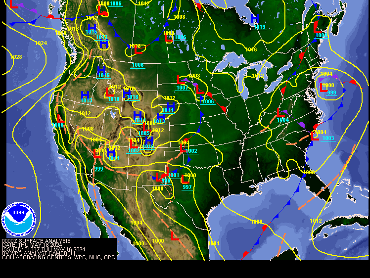
Todays Northeast weather discussion…
Looking at
the surface chart we can see yesterday’s coastal low pressure has pulled away,
with high pressure in complete control. Today through Tuesday, is going to be
mild, with above average temperatures and sunny skies. Mornings will start out
a bit crisp, but temperatures will quickly recover turning very mild by the afternoons.
Most of us will be dry, but I can’t rule
out a few isolated showers over northern Maine over the weekend, especially on
Sunday.
A weak cold front will come through later Wednesday and through Thursday. This will allow for cooler and breezier air to move in for the end of the week, but it won’t be near as cold as we’ve been seeing; the core of the cold will be locked up in Canada. The front won’t have a lot of moisture to work with, so scattered showers are likely, but I don’t see rain amounts being all that impressive. New England could see leftover rain showers Friday morning, as high pressure starts to build in behind the departing front. This should set us up for yet another nice weekend for the end of next week.
Longer range…
Looking out over
the next 30 days, I don’t see any major pattern changes. So, we can expect to
see the current pattern slowly morph its way toward more of a winter and active
pattern. So, expect to see generally milder overall conditions with a few bouts
of cooler air at times.
I will
likely be releasing part one of my winter outlook sometime next week.
Tropical
Atlantic…
We have two
disturbances in the Atlantic Basin
Both are
going to be impacted by the trough dropping south out of the Conus.
Invest 94L is
still there, just north
of Puerto Rico, but it’s a shadow of its former self. The NHC has its current 2
day and 7-day development odds at 10% respectfully. I don’t expect this to
become anything, due to the increased windshear ahead of it.
The other disturbance designated Invest 95L is in the Western Caribbean off of Central America. The NHC has its development odds at 50%. This will, move over the Yucatan into Honduras, Belize and Guatemala within the next 24 hours. From here it will dissipate, so if this is going to become a tropical depression or even a tropical storm, it’s going to have a very short window to do so.
So, what’s going on with me!...
Many have
wondered why I’m not on Facebook anymore. The reason has to do with, people
saying I’m using copyrighted material that I’m not entitled to use. The
pictures I use comes from mainly public sources. To fix the lock down, Facebook
is asking for a lot of information about me, that I don’t think is necessary to
run a Facebook group. Facebook is also pressuring me for money. A lot of y’all
followed me, and trusted my forecasting and weather education. I felt I was
more accurate than most pages, so I don’t understand the problem. I wish I
could still post for y’all on Facebook, but I won’t be extorted by FB or anyone.
So, until I can find a server to post a new website, the Wx4cast site is how
you can follow me. I most
likely won’t be posting every day, but you should check the site once a day to
see if I have. You might want to bookmark the Wx4cast site. If I can see a
significant increase in daily views, I will be encouraged to post more often. This
is an imperfect solution to fix a problem out of my hands, thank you for your patience!
Blogger has discontinued
its use of the ATOM widget used for following my blog. I’m
trying to figure out a work around. Also,
you can leave a comment by clicking the comment link at the bottom of the page,
above the advertisement.


No comments:
Post a Comment
Thank you for taking the time to comment, I will answer as soon as I can.