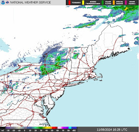
Today’s
Northeast weather discussion…
The surface
chart shows the cold front approaching, with increasing southwest winds ahead
of the front. Radar shows rain over New
York State into northern New England and extending down into western
Pennsylvania. We also see lake effect rain falling northeast of Lake Erie. Lake
effect rain will also be an issue downwind of Lake Ontario today.
Sunday the
high pressure will start to push east, a cold front will approach, as this
moves through, scattered rain showers will work west to east into Monday. I don’t
expect a lot of rain out of this. Tuesday
high pressure move back in along with chilly morning temperatures, then milder
temperatures in the afternoon. Wednesday will be very similar to Tuesday.
Thursday we will be watching a frontal system in the Great Lakes.
Rafael
After
becoming a hurricane last evening, he has rapidly strengthened to a very strong
Category 2, with Max sustained winds of 110 mph, central pressure at 960 mb,
tracking northwest at 14 mph, as he moves along the boundary of that ridge of
high pressure off the Southeast Coast.
He is still intensifying
due to the very favorable conditions. He will likely be a major Category 3
hurricane by the time he reaches Cuba.
As the ridge builds west it should keep him tracking northwest into the central GOM, then likely a shift west before reaching the northern Gulf Coast of Louisiana or Texas. As I’ve been saying there is going to be a lot of windshear and some dry air over the Gulf of Mexico so that should weaken him, prior to any landfall in the GOM. On satellite he is showing good outflow, this will help him battle the increasing wind shear as he gets into the Gulf of Mexico. So Rafael might weaken slower than I’ve been thinking.
On a rare political sidestep when it comes to my post... With the election behind us, I hope as a country, our people can find a way to bridge the deep and bitter divisions, that are the greatest threat to this country. We can disagree without all the hate!


Thank you for your posts I think I finally have got down this commenting
ReplyDeleteTesting 321. 123…
DeleteThis is a transmission
ReplyDeleteIs this the home of a superior weathe forecaster? This is Alan,I will try and fix my name tomorrow. Thank You for figuring this out,your a computer genius also
ReplyDeleteOk,hoping this works and my name is correct.I figured out I had to use my Safari Browser.Google disappeared when I would press comment.Chrome just kept buffering trying to find you.I Love what you have done here.
ReplyDelete