
Today is going to be hot muggy and stormy.
Here is the surface chart and radar

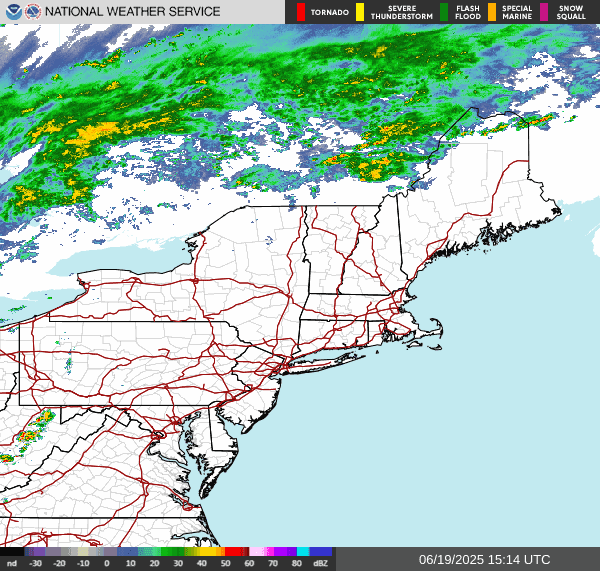
Ahead of the approaching cold front, we're going to see storms explode across the region.
Looking at the visible satellite We can see a lot of sun over eastern Pennsylvania into eastern New York State and southern New England

The sun is going to help things become very unstable as we move through the day Setting the groundwork Severe weather.
Here is today's convective outlook from the storm prediction center (SPC)
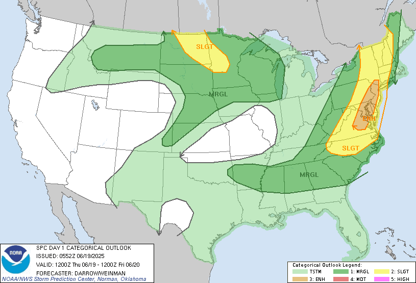


The SPC has a Slight Risk for severe weather extending across much of new England eastern half of New York State down to eastern Pennsylvania. With an Enhanced Risk stretching from Southeast New York State all the way down Through the I95 corridor into Virginia.
Today temperatures will be in the upper 70s into the mid 80s across western Pirates of the region. But further east temperatures will be in the mid 80s into the 90s with very high dew points. Ahead of the strong cold front Across western parts of the region late morning into the early afternoon. The storms will go west to east today into tonight.
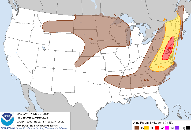
Western parts of the region will face more of an isolated severe threat but any storm that does form will be capable of becoming strong to severe. The main threat will be damaging wind and heavy downpours. Rain totals of half an inch to an inch, will be capable of producing Flooding this will be a specially true over the areas In southwest Pennsylvania into western Maryland that have seen all the rain. As the storms get further east this afternoon we will see more in the way of widespread severe weather across central New York State and central Pennsylvania and points east. This will be especially true for areas closer to an along the I-95 corridor. The storms across eastern Eastern New York State and the eastern half of Pennsylvania into New England and the northern Middle Atlantic will see strong to severe storms. Here the main risk will be strong damaging winds, hail, frequent lightning and heavy downpours, leading to a flood risk; there is a bit of a tornado risk from Western Maine down through much of New England, Eastern half of New York State into eastern Pennsylvania and the Middle Atlantic. The SPC has a risk at 2%. I still think the greatest chance will be over northern New York State and northern New England closer to the Saint Lawrence Valley, As they will be closer to that center of the upper level low pressure moving through Canada.

Southeastern New York State, eastern Pennsylvania, into the northern Middle Atlantic including the I-95 corridor, will see the severe risk late this afternoon and through the evening as that cold front approaches. For areas near and around the I-95 corridor I think there's an increased risk for Microburst.
We will probably see a broken line of storms develop this afternoon into the evening There is a strong likelihood that we'll see bowing segments in this line that will lead to the risk for damaging winds as the line moves through..
The front will continue to push east tonight and tomorrow morning And should be exiting the east coast of Maine by the afternoon. Tomorrow will be cooler with less humidity, There will be a weak trough moving through that could set off a few showers here and there but most parts should be dry. On Saturday we'll see the temperatures and humidity start to edge up a little bit but it still should be fairly comfortable. Sunday will also see some low pressure moving across northern New York State and into New England this could bring some scattered rain showers into parts of New York State and New England. South of there, there will be a chance for some isolated showers but most should stay dry. Sunday will also be beginning of a lot of heat and humidity for the region. Sunday and especially Monday Tuesday into Wednesday we will see air temperatures in the upper 80s to upper 90s. It will be possible some areas could see air temperatures approach 100°F+, dewpoints are going to be in the 70s, making for heat indexes of mid 90s to over 100°F, some areas could see heat indexes over 110°F.
The heat and humidity started to increase around 5 o’clock maybe a little earlier at 10:30 my weather station read 97 which I felt was a little on the high side so I checked the other channel that one said 96 both are around the north side of the house however, the one that said 97 is a little bit closer to the sunlight due to where the sun is rising now. It only stayed ha ha until 1230 and then dropped down to 91 right now it is 89.7. As I was writing this all of the severe warnings were popping up on the screen. I have like five locations some in New Hampshire some in Maine in Vermont and of course around the house and they were all dropping so that took a while and wouldn’t let me talk. The sun is no longer shining around here and high clouds and moved in.
ReplyDeleteOn another note, I saw the drought conditions and the amount of rain that we received through from May, I guess the color I saw explains why you can’t walk in our backyard without getting your sneakers wet because the water is right up to the base of the grass and you can see the water sitting there We get a thunderstorm or two with heavy rain. I believe that our lawn will be under an inch of water or so. If we get any type of torrential rain your, about possible flooding, I think would be realized around here for our small streams in Brooks, but even the Hoosick river Would go up high fairly quickly due to the fact that it’s running on the high side from all the rain and the ground being saturated so we’ll be watching for that. The best news is that my AC pack in had to leave it off for a while and it still is resting. I’m gonna have to put it on another power strip. This one seems to be old. The temperature went from a lovely 67 to a balmy 72 and less than an hour. I think I’m gonna go find that new power strip and plug it in because it’s starting to get a little steamy in here. Have a great day and thank you for the update.
Thank you for letting us know how it is there.
ReplyDelete