
The cold front responsible for all the severe weather yesterday Is off the coast, taking the heat and humidity with it. Today will be cool. But it won't last for long.

The summer solstice starts tonight at 10:41PM.
We look to see a mesoscale convective system (MCS) develop in the North Dakota and Minnesota tomorrow This will move east and then south and east as it rotates around that huge high pressure ridge of heat in the Plains. A MCS, is a large organized group of thunderstorms, that can last for several hours and travel hundreds of miles. MCS's can bring lots of rain and the risk of damaging winds, Hail and even some tornadoes can also be an issue. During the night MCS's can become very intense. This could hold together for very early Saturday into Saturday morning, for this reason the storm prediction center (SPC) has issued a Slight Risk on Saturday, for severe weather over the Great Lakes into New York State and northern Pennsylvania. This will be for the evening into the night on Saturday, we could see more strong /severe storms associated with a warm front, but the main woody will be what's dropping in out of Canada across New York State into New England, as things rotate around the ridge.

The SPC does have a Marginal Risk for severe weather on Sunday for northern and eastern New York State into new England.

This will be due to strong and severe storms in the Upper Midwest forming and moving over the top of the heat ridge and then sliding down into the Northeast. The ridge over the Plains will push east over the weekend.
Heat and humidity will start to build back north on Saturday. By Sunday, Monday and Tuesday we will be completely under the heat dome. Which will be bringing the Northeast and Middle Atlantic region a lot of heat and humidity. Some of this could last into Thursday. Those under the ridge will have a chance for Isolated rain showers and thunderstorms; but those closer to and along the edge could stay active as systems continue to rotate around this huge dome.


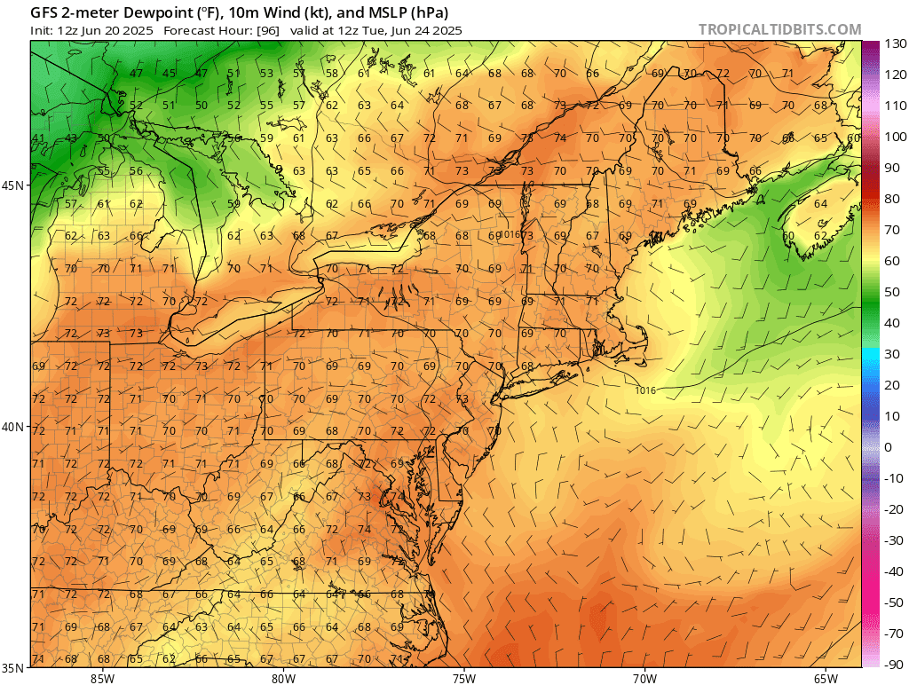
Images courtesy of tropical tidbit

Image courtesy of pivotal weather.
This will be the hottest weather we've seen so far this year and be the and it will likely be a heat wave for many of us. So remember your hot weather safety tips Drink plenty of water,wear a hat, sunscreen and light colored clothing,try to limit your time outside and take plenty of breaks if you're going to be working out in the heat. Make sure you keep checking on children And if you have animals and pets Make sure they have plenty of water available and keep them cool.
As we get close to the end of June into the first bit of July, the ridge will be breaking down We will return to cooler weather at least for a while.
Yesterday we got up into the low 90'sfor a brief time.Today was in the mid 80's for a brief time then I noticed the trees bending.I went outside and it was extremely windy dropping the temps into the mid 70's.We didn’t receive a drop of rain either day.
ReplyDeleteTomorrow is a huge graduation party for my.neice.This is going.to be a monster event as another family member goes into the medical field.It starts at 1,give me the straight weather news as only you can.How wet will Northern Berkshire County get and around what time.Thank You for your time and effort.🌈
Alen, Saturday during the day It will be a bit warmer, but humidity shouldn't be too bad. I can't rule out a straight shower here or there. So you should be ok. The main risk will be Thunderstorms for Saturday night Into Sunday morning.
ReplyDelete