Monday, March 24, 2025

March 24th, 2025.


Doesn't act much like Spring.


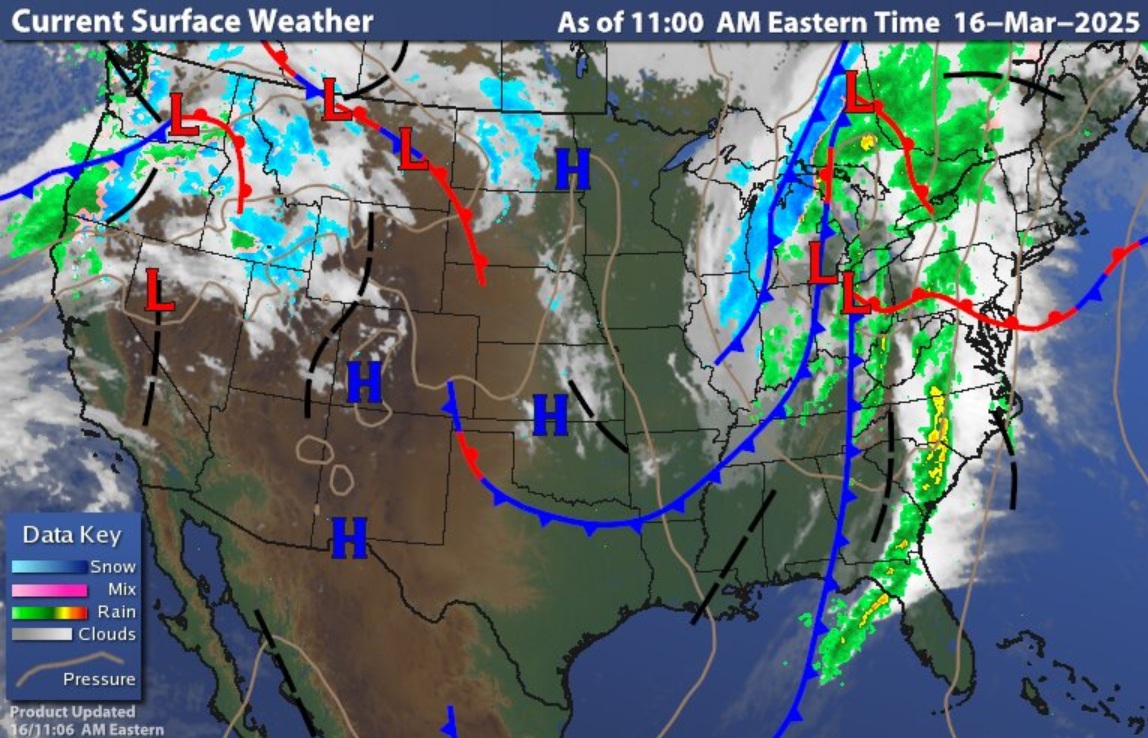
Surface chart shows low pressure over the Great Lakes will a cold front setting over western parts of the region, this is moving west to east. Radar, shows rain across southern New England and down the I-95 Corridor down through Virginia; it also shows the snow/mix over northern into central New England.  

Today will be seasonally chilly with gusty winds that could gust up to 30 to 40 mph at times. It will remain unsettled across New York State and Pennsylvania, with the rain and snow continuing for the eastern part of the region. Rain amounts of 0.25 to 0.50 with locally higher amounts up to around an inch will be possible, rain could be moderate to heavy at times. The higher elevations of northern into Central New England could see 3-6 inches of snow.  

Tonight, will remain cloudy during the morning and quite cool. Tomorrow, but as the cold front clears the region, clouds will diminish west to east during the day.  It will stay breezy with winds gusting to over 30 mph at times. There will also be a chance for a few rain/mix snow showers across northern New York State and northern New England. High pressure will briefly setup for Tuesday, but this will quickly move out during the day.


Late Tuesday/Wednesday Clipper

An area of low pressure is going to drop into the Northern Middle Atlantic, this will then head north and east toward the Gulf of Maine.  Temperatures will still be seasonally chilly

New York City, Long Island into Southern New England including Boston could see some light to maybe moderate impacts for the commute Wednesday. But with very moderate temperatures, it should be just rain. There could be some snow/mix for inland areas away from the Coast. North of there will see a chance for scattered snow/sleet/freezing rain across upstate New York and northern into Central New England, but any accumulation should be fairly light. There will be a chance for higher accumulations of snow for parts of the Appalachians and Pennsylvania's Laurel Highlands.

Thursday will see high pressure build in, keeping temperatures quite cool.  Friday will see a warm front approach and move through, allowing temperatures to climb a bit.  Over the weekend an area of low pressure will be over the Great Lakes, this looks to drop south and east across Southern New York State/Pennsylvania.  Saturday will see a warm front move over the region, followed by a cold front. So, the weekend looks to be unsettled.

The AO and NAO will be negative in the 6-10 day, with the WPO going negative as well. This will make for a pattern that is cooler than average for the next week or two. I still think a surprise snow storm is quite possible before we get to real spring.  So, we can expect to see the pattern stay active, with additional shots of cold air.  I do expect to see real spring set up for Mid-April.


Saturday, March 22, 2025

March 22nd, 2025.


My weekend post on the coming weeks weather. 


Today is milder with breezy northwest winds, 10-20mph with gusts to 25-35mph. We have a trough swinging through today. This will bring scattered rain showers to the region, then as cooler air filters in the rain will change over to some snow across parts of New York State and Northern into Central New England, especially in the higher elevations. Any accumulation will be light. We also have an area of low pressure in the Upper Plains, that will head toward the Upper Great Lakes. This will push through the Northeast on Monday.

Tomorrow will feature sunny skies, with cooler temperatures with the breeze continuing.  The before mentioned system will be approaching Sunday night. The air looks to be cold enough for precipitation to start out as some snow across New York State into New England. But as the warm front lifts through this snow will change over to rain over New York State Monday morning and then during the afternoon for New England. The system will bring more in the way of widespread rain showers, general amounts look to be 0.10 to 0.25 inches but there could be locally higher amounts.  The higher elevations of upstate New York and northern into central New England could see 1-2 inches of snow with locally slightly higher amounts possible. The Tug Hill could see an additional 1-3 inches of lake enhanced snow as well. Most of the coming week will feature slightly below average to below average temperatures.

Tuesday into Wednesday a system will be moving across the Ohio Valley this will be dropping south and east into the Middle Atlantic. The system looks to be weak, but rain showers are possible across Pennsylvania, Maryland, Delaware into New Jersey, north of there, rain/snow showers will be much more isolated. There could be accumulating snow for parts of the Appalachians and the Laurel Highlands. Rain/snow showers will extend into Thursday.


At the same time our next cross-country system will be entering the Pacific Northwest Tuesday and Wednesday.  This will likely lead to low pressure developing in the Plains. This would mean the chance for a severe weather outbreak across parts of the Plains and Southeast. This storm looks to track farther south than the last two. So, this could have a bigger rain impact on southern parts of the region than we’ve see the last couple of weeks. Northern parts of the region would be dealing with the rain/mix/snow mess like we’ve been seeing.

This active weather pattern looks to continue into the first half of April, but by the 2nd week of April, I do think we’re going to stay progressively warmer, along with greater chances for severe weather.

For those of you wondering; I've cut back on posting on the daily weather; I'm just not getting enough views to take all the time it takes to do the forecasting. How the site goes will depend on how many views and followers I get. So we will see how it goes. I want to say thank you for the few who do follow what I write, and I'm sorry to have to cut back, but if there isn't enough interest, I just can't take the time to do all of this. I had said I wanted to do a Youtube channel... but before I can do that I need a lot more than 30-70 views a day! 


Thursday, March 20, 2025

March 20th, 2025.


Welcome to the first day of Astronomical Spring.

The surface chart shows primary low pressure moving into the Great Lakes with an attached cold front.


Satellite shows the system approaching our region, and another moving into the Pacific Northwest.


We have rain showers ahead of the cold front over western parts of the region. This rain will continue to push east over the course of today and tonight. Rain could be moderate to heavy at times.  General rain amounts look to be 0.25 to 0.50 of an inch. Out ahead of the frontal boundary it is still mild. A secondary low is going to form along the frontal boundary. Southern winds will ramp up to 10-20mph, with gusts 30-50 mph. There will be a chance for isolated thunderstorms; especially over much of Pennsylvania, New Jersey, Maryland, and Delaware, a few of these could be on the strong side. Cold air will come in behind the front, this will turn rain over to a mix/snow The Poconos could see a few snow flurries that lead to some accumulation.  While most areas across northern Pennsylvania, Northwest New Jersey, New York State, and New England, look to see some snow showers, little to no accumulation is likely. The risk for accumulating snow of a couple of inches is greater for elevations of 500 feet and above, with the higher elevations above 1500 feet in the Catskills, Berkshires,  Adirondacks, Greens and Whites, 3 to 6 inches will locally higher amounts will be possible in these areas

Tomorrow will remain chilly with gusty winds hanging around Saturday will see the winds lessen with temperatures becoming warmer. Saturday starts out dry, but a weak disturbance slides through during the day producing a chance for isolated rain showers and high elevation snow showers. Sunday is looking to be generally dry, but another cold front will approach and move through later in the day into Monday, bringing more in the way of widespread rain, general amounts are looking to be 0.25 to 0.50 of an inch, as colder air filters in with the trough, rain showers will likely change over the snow showers especially in the high elevations.


The next couple of weeks will feature general coolness, as we experience a lot of trougheness over the Great Lakes and the Northeast. As I said in my long-range post yesterday the pattern will remain active. So as these systems roll out of the west, we will have to be watchful for snow on the northern side of the tracks. There is still the chance for a surprise snowstorm for at least part of the region.

Wednesday, March 19, 2025

Long Range Outlook


We had a disruption in the Polar Vortex last week. This is typically the time of year when the PV breaks down, as the pattern adjust to Northern Hemisphere (NH) Spring. When we look at the height pattern over the NH, we can see high pressure and warming temperatures over the North Pole, with the colder air dispersed into the lower latitudes, again this is normal for this time of year.


This supports the idea of the pattern staying overall cool and active.

Other teleconnections

The Arctic Oscillation (AO) is currently positive and trending towards neutral. The AO looks to stay near neutral next week. The North Atlantic Oscillation (NAO) is currently negative trending neutral. Then the NAO looks to stay near neutral over the next two weeks.


The AO and NAO are indicating we will see general ridging over the Eastern CONUS and Eastern Canada behind the storm for tomorrow. Then a trough will push in over the region for Next Week, allowing for generally below average temperatures for our neck of the woods.

Madden Julian Oscillation

Currently the Madden Julian Oscillation (MJO) left phase three into the center circle where no phase is favored. It looks to hang out inside the circle for the seven to 10 days, then emerge into phases six and seven. Phase six and into phase seven favors strong ridging with mild temperatures for the Eastern US.


All of this is supported by the CPC 8-14 day, which shows generally below average temperatures over the Northeast into the Northern Middle Atlantic over the next couple of weeks. The CPC is also showing the Northeast into Northern Middle Atlantic seeing above average precipitation over the same time period.  


SSTs/El Nino/Southern Oscillation

Looking at the equatorial Pacific Sea Surface Temperatures (SSTs) anomalies, we can see the SST between the Dateline and Indonesia are still below average at 0.4°C, with the other three Nino areas showing temperatures starting to go positive. This means the La Nina is rapidly waning. I expect we will be officially under neutral conditions over the next 4 weeks.


So, after the cooldown next week into the first week of April, Spring should make a big return and stick around.


March 19th, 2025.


We have a storm in the central Plains; there will be blizzard conditions on the northern side and a severe weather risk across Illinois, Kentucky, Indiana into Ohio.  

Out ahead of all of this, today will be dry with a breezy southern flow, bringing very mild temperatures. High pressure overhead means there will be plenty of sunshine.  


As the low in the Plains heads into the Great Lakes clouds will increase tonight into Thursday. Winds will be increasing during today. And the strong breeze will last through the overnight, along with these mild conditions.

The vernal equinox officially begins at 5:01 AM Thursday.

As low-pressure slides into the Great Lakes, the attached cold front will be approaching Thursday morning with scattered moving into western Pennsylvania and western New York State. These hit and miss showers will work their way east, reaching western New England and the mid Atlantic late in the day into the evening. Rain will be moderate to heavy at times.  A secondary area of low pressure will develop Thursday over the Middle Atlantic, This will increase the risk for isolated thunderstorms across southeast Pennsylvania Maryland and Delaware, severe weather is unlikely, but a few cells could be strong, this area of low pressure will be moving into the Gulf of Maine on Friday

As colder air slides in behind the front, rain will change over to some snow, there could be a few wet snowflakes across the region, but little if any snow accumulation is expected. There could be a few flurries for the Poconos and Catskills with light accumulations possible. Northern New York State and Northern into Central New England could see a dusting to a couple of inches, with the higher elevations of the Tug Hill, Adirondacks, Greens into the Berkshires along with the Whites could see higher amounts adding up to a few inches.  Those with the best chance of seeing any snow accumulation will be 500 feet and above.

Friday into Saturday will be rather cool, with a breeze. A weak area of low pressure with a cold front will move across the region on Saturday, with the cold front there will be widely scattered rain/snow showers. Sunday will see high pressure back overhead, so we should be dry and sunny.  Monday will see another system roll through bringing rain and northern snow showers.


Tuesday, March 18, 2025

March 18th, 2025.


Today and tomorrow, will be dry, sunny and warm; satellite and radar show clouds over New England as low pressure with the rain continuing to push east. Then we will see another system approach and move through for Thursday into Friday.


Temperatures will continue to climb today as high pressure sets up, and they will stay mild going into tonight. Tomorrow will see a strong southern breeze will drive temperatures much warmer. Our next rain maker, is over the Rockies, this will emerge in the Plains and upper Midwest tonight into Wednesday where it will create blizzard or near-blizzard conditions north and west of the low. The low will continue to strengthen over the central plains as it heads for the Great Lakes Wednesday into Thursday.   This is going to kick off more severe weather, but it doesn’t look to be as bad as what just occurred. Currently the SPC has part of the Ohio Valley under a Marginal Risk for tomorrow.  

Ahead of the cold front rain will move into western Pennsylvania and western New York State Thursday morning; this will move east across the Pennsylvania and New York State during the rest of the day, reaching the Middle Atlantic, Hudson Valley and western New England Thursday evening; then eastern New England Thursday night.   Rain could be heavy at times. Rain amounts look to be 0.25 to an inch for most of us.  We can expect thunderstorms along with the rain. This time around, the severe parameters aren’t going to be as stout, with a better chance for severe storms over Virginia into the Carolinas. But some of the thunderstorms over the region could contain some gusty winds. We will see how this all evolves over the next couple of days.

Behind the cold front temperatures will become much cooler. This will change rain over to a mix/snow. Most locations across New York State and Northern and central New England, will see little to no accumulation, but the higher hills, Tug Hill region, Adirondacks, Greens, Berkshires, and Whites could see a few inches. The Catskills and Poconos could see some accumulation from mix/snow as well.   

Friday will be cold but should generally be dry. Saturday will see temperatures start to warm as a weak area of low pressure approaches and moves across Pennsylvania on Saturday, bringing a chance for some rain/snow showers. I don’t expect any additional accumulations. Sunday is looking to be clear and dry with rebounding temperatures.  Sunday night and Monday another area of low pressure moves through bringing rain and higher elevation snow showers. Tuesday is looking unsettled as we will be dealing with a trough over the region.


Monday, March 17, 2025

March 17th, 2025.


Happy St Patrick’s Day, today is the day everyone is Irish, but some of us are lucky enough to be Irish every day. I hope all y’all find a pot of gold!


Yesterday’s cold front is pushing east and the heaviest rain is currently over New England. Behind the front there are breezy winds and light showers. Temperatures behind the front will continue to fall today.


The storm brought a general 0.50 to 1.25 inches with localized amounts of 1.5 to near 3.0 inches. With the snow melt and recent mild temperatures areas with deep snowpack are dealing with flooding, The flood concern will continue as we move forward this week. There were several severe thunderstorm warnings issued that produced numerous hail and wind damage reports across western into central New York State and Pennsylvania.

High pressure is setting up overhead, this high pressure will be with us through Wednesday, the next couple of days look to be generally dry, with temperatures turning mild tomorrow, temperatures will be even warmer on Wednesday.


I’ve been talking about our next storm for over a week now.

Tuesday into Wednesday Low pressure will move out of Colorado into the central Plains. This is going to really deepen over Kansas. From here it will move north and east toward the Great Lakes. This one doesn’t look to be quite as strong as the last one, but there will be heavy snow on the northern and northwest side of the system, this is also going to produce another severe weather outbreak.  

Thursday will see the storm approach our region; Thursday will start out warm. Then a cold front will approach and move through. Rain will start across western Pennsylvania Thursday morning, the rain will continue to push across New York State and Pennsylvania through the afternoon, then make it into western New England Maryland, Delaware and New Jersey later in the day and evening, then into eastern New England Thursday night.  Winds will be gusty as the frontal boundary moves through.

The spring equinox arrives at 5:01am Thursday!

Cold air will be swinging in behind the cold front, changing rain over to a bit of snow.  There could be some minor accumulations over parts of New York State and northern into central New England, especially in the higher elevations.  Temperatures will be cooler for Friday into Saturday as high pressure builds in overhead.  Saturday night into Sunday will see a weak system roll through bringing some rain showers, along with a chance for some snow showers over New York State and northern and central New England.

The storm later this week, doesn’t look to be the last, there are signals that another one is going to form behind the one for later this week.

Sunday, March 16, 2025

Tornado Watch 54


SEL4

   URGENT - IMMEDIATE BROADCAST REQUESTED
   Tornado Watch Number 54
   NWS Storm Prediction Center Norman OK
   1250 PM EDT Sun Mar 16 2025

   The NWS Storm Prediction Center has issued a

   * Tornado Watch for portions of 
     Western Maryland
     Western and Central Pennsylvania
     Northern Virginia
     Eastern West Virginia

   * Effective this Sunday afternoon and evening from 1250 PM until
     700 PM EDT.

   * Primary threats include...
     A couple tornadoes possible
     Scattered damaging wind gusts to 70 mph likely

   SUMMARY...A line of thunderstorms will move quickly northeastward
   this afternoon and evening, while posing a threat for mainly
   damaging winds with peak gusts up to 60-70 mph. A couple of
   line-embedded tornadoes may also occur.

   The tornado watch area is approximately along and 40 statute miles
   east and west of a line from 75 miles north of State College PA to
   10 miles west southwest of Staunton VA. For a complete depiction of
   the watch see the associated watch outline update (WOUS64 KWNS
   WOU4).

   PRECAUTIONARY/PREPAREDNESS ACTIONS...

   REMEMBER...A Tornado Watch means conditions are favorable for
   tornadoes and severe thunderstorms in and close to the watch
   area. Persons in these areas should be on the lookout for
   threatening weather conditions and listen for later statements
   and possible warnings.

   &&

   OTHER WATCH INFORMATION...CONTINUE...WW 51...WW 52...WW 53...

   AVIATION...Tornadoes and a few severe thunderstorms with hail
   surface and aloft to 1 inch. Extreme turbulence and surface wind
   gusts to 60 knots. A few cumulonimbi with maximum tops to 350. Mean
   storm motion vector 22045.

   ...Gleason

March 16th, 2025.


Today is very mild. Widespread rain and embedded thunderstorms are working there way across the region today.


An approaching cold front will bring the threat for strong winds and severe thunderstorms. Those at the highest risk for seeing severe thunderstorms will be south and west of Central New York State. Across the rest of the region gusty thunderstorms will be possible, some of these could be on the strong side. The main risk today will be damaging winds, with gust as high as 70 mph, along with heavy rain.  Hail and isolated tornadoes are also possible; a Tornado Watch is in effect across western Pennsylvania until 4 PM.


The SPC has a Slight Risk for severe weather across part of Maryland (including DC), western into central Pennsylvania and southwest New York State (including the Finger Lakes), There is also an Enhanced Risk over all of western Pennsylvania into extreme southwest New York State.  

Wind advisories and flood watches are up across parts of the region. With all the rain and extremely mild temperatures, places like the Tug Hill region are at a high risk for flooding due to runoff into streams and rivers. If you live near streams and rivers, be aware of ice jams, there can be little to no warning if you’re going to be hit by one.

Cold air is going to come in behind the cold front, but it won’t last long. Tuesday into Thursday will see a warming trend.  The spring equinox will arrive on Thursday at 5:01 a.m. ET.

Tornado Watch 53


 SEL3

   URGENT - IMMEDIATE BROADCAST REQUESTED
   Tornado Watch Number 53
   NWS Storm Prediction Center Norman OK
   1030 AM EDT Sun Mar 16 2025
  The NWS Storm Prediction Center has issued a

   * Tornado Watch for portions of 
     Eastern Ohio
     Western Pennsylvania
     West Virginia

   * Effective this Sunday morning and afternoon from 1030 AM until
     400 PM EDT.

   * Primary threats include...
     A few tornadoes possible
     Scattered damaging wind gusts to 70 mph likely

   SUMMARY...Multiple lines and clusters of thunderstorms will continue
   to develop and intensify as they move quickly northeastward late
   this morning and into the afternoon. Scattered damaging winds will
   likely be the main threat with this activity, with peak gusts
   perhaps reaching up to 60-70 mph. But, the environment will also
   support some threat for a few line-embedded tornadoes as well.

   The tornado watch area is approximately along and 60 statute miles
   east and west of a line from 30 miles northwest of Franklin PA to 40
   miles south southeast of Charleston WV. For a complete depiction of
   the watch see the associated watch outline update (WOUS64 KWNS
   WOU3).

   PRECAUTIONARY/PREPAREDNESS ACTIONS...

   REMEMBER...A Tornado Watch means conditions are favorable for
   tornadoes and severe thunderstorms in and close to the watch
   area. Persons in these areas should be on the lookout for
   threatening weather conditions and listen for later statements
   and possible warnings.

   &&

   OTHER WATCH INFORMATION...CONTINUE...WW 51...WW 52...

   AVIATION...Tornadoes and a few severe thunderstorms with hail
   surface and aloft to 1 inch. Extreme turbulence and surface wind
   gusts to 60 knots. A few cumulonimbi with maximum tops to 350. Mean
   storm motion vector 22045.

   ...Gleason

Saturday, March 15, 2025

March 15th, 2025.


The powerful storm system that brought severe weather including several tornadoes yesterday and last night has moved east into the Mississippi Valley and Deep South for today, several people have already died, and today is going to likely be worst. There is a very high likelihood for a violent tornado outbreak starting this afternoon right through tonight. 


The SPC has issued an exceptionally rare and dangerous level 5 high risk. A risk level 5 means that numerous severe storms will be likely and there is a high confidence of severe weather. All threat modes are possible, including significant tornadoes, strong and damaging wind gusts, damaging hail, and flash flooding. Stay prepared, stay weather aware. Have multiple ways of getting weather alerts. The areas at most risk will be Alabama, Mississippi, Louisiana, western Georgia, southern Tennessee, southern Arkansas, and the Florida Panhandle, there are likely going to be long-track violent tornadoes so everyone in these areas should stay weather aware.


There are five risk categories: marginal, severe, enhanced, moderate, and high.


What is a severe thunderstorm?

A thunderstorm is classified as severe if it meets one of the following criteria:

Winds greater than 58 mph

Hail diameter greater than an inch (quarter-sized)

Contains a tornado

If you’re under any kind of risk, there is a chance for severe weather to occur. So always prepare for the possibility of a severe thunderstorm hitting your area.


Today is very warm, and tomorrow will be even warmer. Winds will be increasing today, and will become very gusty tomorrow as a strong cold front approach and moves through.  The entire region is going to see widespread rain heavy at times. A general 0.50 to 1.0 inches of rain; this along with snow melt will likely lead to flooding including ice jam river flooding.


The severe weather will push east for tomorrow, but the systems dynamics shouldn’t be as potent. But that doesn’t mean there won’t be any severe weather.  Currently the SPC has a Marginal Risk for strong to severe storms across Pennsylvania. There is also a Slight Risk for severe weather over part of Maryland, including Washington DC.  There will be a couple of lines that will move through, the biggest risk will be damaging winds, but hail and isolated tornadoes will also be possible. Areas that see thunderstorms will have a greater chance of seeing 1.5 to perhaps 3 inches of rain.

St Patrick’s Day will see much cooler air move in. But the lower temperatures don’t hang around for long; as a warming trend starts on Tuesday The region will stay mild into Thursday. Wednesday we will be watching another system drop into the Plains out of the Rockies, this will likely lead to another severe weather outbreak for the Plains and south. The cold front attached to this system will roll through the region on Thursday and Friday. We will be warm enough for all rain, but then as colder air comes in behind the front, rain will change over to snow over New York State and northern and central New England. There looks to be some accumulation, especially in the higher elevations of the Tug Hill, Adirondacks, Greens and Whites.


Friday, March 14, 2025

March 14th, 2025.


Who saw the total lunar eclipse?


The surface chart shows, high pressure is in control with our developing storm in the central CONUS. This is going to lead to a big severe outbreak for the Mississippi Valley, eastward into the Lower Ohio and Tennessee Valleys later this afternoon into Saturday morning. For our region, satellite and radar show we have plenty of sunshine and dry conditions across the region.   Ahead of the western system, southwest winds will be driving mild temperatures today.  Tonight is going to stay mild and dry.

Saturday is going to see that western storm slowly approaches the Great Lakes. Temperatures are going to continue to climb. Clouds will be increasing as a warm front lift into the region.  As the warm front advances, southwest Pennsylvania, should see isolated showers develop late morning to early afternoon.  As the warm front move through, the isolated rain showers will advance with it across the region.  The southern flow is going to increase on Saturday, so winds will be getting gusty.  Thunderstorms will be approaching western parts of the region, some of these could be strong across western Pennsylvania and western New York State.


Saturday night and through Sunday the strong cold front will approach and move through. Rain across the region will move west to east and become steady and widespread. Winds will also become very gusty, with winds of 20 – 30 mph with gusty of 40-50 mph possible. Northern areas could see some embedded thunderstorms, the rest of the region will have a chance for strong to severe thunderstorms, this will be especially true for Pennsylvania, Maryland, Delaware into New Jersey.  Sunday is going to be even milder than Saturday, general rainfall amounts of 0.50 to 1.0 inches can be expected, with those who see stronger thunderstorms having a chance for higher amounts.  Winds will be the main danger with these thunderstorms, but hail and even an isolated tornado is possible.

Monday morning the rain will be over New England and pushing east. Rain should be pushing offshore during the afternoon.  High pressure will move into the region, with temperatures turning back to seasonal cool. The high pressure will stay overhead for Tuesday and Wednesday, temperatures will be quite mild as well.   Thursday another cold front will approach, bringing widespread rain, windy conditions and some thunderstorms, ahead of the front temperatures will become very mild.  For Friday into Saturday colder air will be moving in, rain will be changing over to snow west to east across part of Pennsylvania, New York State and central and northern New England, some accumulation is likely especially for the higher elevations.


The region is still experiencing drought, so the rain is welcome! 


Areas with a deep snowpack will have to keep an eye on streams and rivers, flooding and ice jam flooding will be a big concern over the weekend!


Wednesday, March 12, 2025

March 12th, 2025.


Howdy, I’m back.

We’re in a zonal flow (west to east), with no major systems over the next few days.


We have high pressure anchored in Canada extending over the region, with a Backdoor cold front well to our south.  Temperatures are much chillier than yesterday and radar shows the region is dry, but we can see a clipper approaching from the west that will bring rain and snow showers this evening into tomorrow morning, snow accumulations will be a dusting to maybe a couple of inches, especially over the higher terrain of Southern New York State into northern Pennsylvania.

Tomorrow, we’re still going to be cool, but a little warmer than today. Once we get into mid to late morning, we should be generally dry. Skies will be clouding up during the day; these clouds will make seeing a total lunar eclipse Thursday night problematic, with partly to mostly cloudy skies. Friday will see an increasing southern flow, which will allow us to really warm up, the day looks to be dry, with ample sunshine.

A system that will roll in from the Plains, looks to bring a multiday severe outbreak over the Southern CONUS. A primary low is going to head for the Great Lakes, the system will be pushing a warm front through the region, allowing temperatures to become warmer for Saturday. With the warm front there will be a chance for isolated rain showers, but many might not see them.  Sunday a secondary low look to form along with a strong cold front, ahead of the front southern winds will become very gusty, these will allow temperatures to climb well above average. Along with the front, widespread rain, and embedded thunderstorms are likely, rain could be heavy at times. Monday morning the front will be pushing west with rain over New England back into the Middle Atlantic, during Monday the front is going to slow down. But by mid afternoon Monday the front should push to the east. General rain amounts look to be 0.50 to 1.0 inches, with some locally higher amounts.

With the rain, and warm temperatures, rivers and streams will have to be watched as there will be the risk for general flooding and ice jam flooding.


Friday, March 7, 2025

March 7th, 2025.


Long Range look at March.


March has been active and it will stay that way. We’re going to have several systems come through over the next 7 to 10 days, along with wild temperature swings.  The storm responsible for the wintery mess and all this wind is still up over the Canadian Maritimes, we’re it is still wrapping up, so the winds will be with us tomorrow as well.  Another storm is going to crash into the West Coast, this one looks to move into the Plains and become quite strong, then it looks to push toward the Great Lakes, with possible impacts similar to the one we’re dealing with now. Impacts will depend on the storms track.

Over the weekend it will be seasonally cold with a couple of weak disturbances move through bringing a chance for a few snow showers over northern parts of the region. Most areas will see a coating to perhaps 3 inches, with the higher elevations having a chance for 3 to 6 inches with possibly higher local amounts. The rest of the region will run the risk for a few rain showers.  Change your clocks ahead on hour when you go to bed, Saturday night. Sunday the winds will weaken a little. But then on Monday a fast-moving clipper, will bring snow/mix/rain along with a return of strong winds. Monday will be the beginning of a warming trend, so northern snows should end up changing over to rain.

Tuesday into Thursday is looking to see temperatures become very mild. But a backdoor cold front will be close by, so that could put a fly in the ointment; so, depending on where it ends up there could be a temperature divide across the region. We will also have to keep on eye on the storm in the Plains as we get into mid to end of next week.  Then there could be another big storm for next weekend into the following week.


The polar jet has weakened. So, we’re seeing these cold outbreaks move across the CONUS. These outbreaks will likely lead to more severe outbreaks, and U.S. northern tier snow over at least the next couple of weeks.  So, our current pattern looks to stick around for the foreseeable future.


Thursday, March 6, 2025

March 6th, 2025.


The climb toward spring continues.


The system and cold front are pushing east. Today is going to be mild with a mix of clouds and sun. Winds will become very gusty into tomorrow.  There are wind advisories and high wind warnings in parts of the region, these will be effect for later today/tonight into tomorrow. Sustained winds of 15 to 30 mph, with gust of 4o to near 60 mph will be possible. The radar shows snow showers over western parts of the region, as the colder air starts to move in.  The colder air will move west to east slowly, so many of us will stay mild for the next few hours. Then the cold air will move through, snow will be light, with 1-3 inches possible in Parts of Pennsylvania, New York State into northern and central New England. The higher elevations of the Adirondacks, Greens and Whites and northeast Maine could see 2-5 inches, with the Tug Hill picking up 3-8 inches of snow. Everyone else will pick up mostly all or all rain, with parts of the New England Coast seeing less than an inch.

Tonight, into tomorrow lake effect will be falling downwind of Lake Ontario. Winds will start to weaken on Friday ahead of another weak system rolling through late Friday into Saturday, this will bring the chance for scattered rain/snow showers. There could be some light accumulations across northern areas, especially in the higher elevations, with no accumulation south of there.  Temperatures over the Weekend will be seasonable.  Sunday will be fairly sunny, as high pressure sets up overhead, temperatures will warm a little, but they will still be chilly.

Monday will be a little warmer as a weak clipper passes to our north, dragging a weak trough through the region, there could be a few rain/mix/snow showers across northern Pennsylvania, New York State and New England, not expecting much in the way of accumulations, across the rest of Pennsylvania and northern Middle Atlantic there is only a slight chance for a few isolated showers.

Tuesday the warming trend continues, as high pressure stays over the region. Wednesday and Thursday it’s going to become very mild, Wednesday we will have a little disturbance pass to our north, this could bring rain/mix snow to far northern parts of the region but the rest of the region should stay dry.  Thursday will start dry, then we will be watching a storm approach from the west.


Wednesday, March 5, 2025

March 5th, 2025.


The chance for severe weather returns.


Strong Low Pressure heading into the Great Lakes, is pushing a warm front through the Northeast. Today is going to be quite mild and very breezy. We have a few snow showers up over Maine. But this will change over to all rain. We’re going to see widespread rain today, with the rain being moderate to heavy at times, general rain amounts of 0.50-1.50 inches with pockets of lower and higher amounts possible. This combined with snow melt will lead to the risk for flooding, here is a look at the warnings and advisories from “Pivotal Weather”, the areas in dark green show a Flood Watch and are most at risk for flooding, this will be especially true for poor drainage areas. There is also the risk for ice jams across parts of the region, so keep an eye on those streams and rivers.  


There will be the risk for strong to severe thunderstorms. The winds aloft are very strong, there is a chance for these to mix down to the surface this afternoon and evening. We have a risk for thunderstorms, the SPC has a Slight Risk for severe weather over a large part of Pennsylvania, Maryland, Delaware, and southern New Jersey, With a Marginal Risk up into Western New York State, Northeast Pennsylvania, and much of the rest of New Jersey. With the strong winds aloft, thunderstorms will be capable of taping into that, leading to the risk for damaging wind gust upwards of 55 to 60 mph. Besides the wind threat, there is also a risk for hail and perhaps isolated tornadoes.

The cold front will move through Tomorrow, with the front we will be dealing with very gusty winds, Gust of 30 to 50 mph will be possible.  Tomorrow will continue to be very mild, with the cold air behind the front delayed a little. But temperatures will be falling, we’re going to see rain showers change over to flurries/ light snow showers and some mix during the day on Thursday into Friday morning; along with some lake effect snow off of Lake Ontario. Most will see little to no accumulations, but 1 to 3 inches of snow will be possible across parts of Pennsylvania, New York State and New England, the Tug Hill, Adirondacks, Greens and Whites could see 3-6 inches of snow.

Friday will still be windy as the storm departs allowing high pressure to build in, providing more in the way of sun, despite the sun, Friday and the weekend will be quite chilly, with temperatures becoming seasonal, those downwind of Lake Ontario, will be dealing with lake effect snow. Saturday a weak system, will bring the chance for isolated rain showers for southern areas, and some snow showers over northern areas, it will still be windy. Sunday is looking to be seasonally cool but generally dry along with lessening wind. Monday a clipper will move through bringing southern rain showers and northern snow showers.  Behind the clipper, high pressure builds in for Tuesday. The high pressure looks stay overhead for Wednesday, by midweek, temperatures will become very mild once again.