Sunday, August 30, 2020

My 2020 Fall Outlook


The days are getting shorter, and the leaves on some of the trees are starting to change. Fall kicks off on Tuesday September 22, at 9:30 am, EDT. But if any of Y’all are waiting for those comfortable fall daytime temperatures and those cool crisp fall nights; You might want to get comfy, because those kinds of conditions aren’t going to show up for a while, at least in a long-lasting matter.

Over the last four to five years, fall has arrived late, with summer like temperatures hanging around through September. That trend is looking to include this September as well.

There is no doubt that the entire Northeast and Mid-Atlantic have been hot this summer. In fact, much of the CONUS into Canada has been very warm.


The El Nino Southern Osculation (ENSO)

The ENSO is going to be one of the major factors driving the fall pattern. The Madden Julian Oscillation (MJO) is going to be another big factor.

The ENSO has a warm (positive) phase El Nino and a cool (negative) phase La Nina.

La Nina is when the East-Central equatorial Pacific is cooler than average. NOAA currently has an enhanced La Nina watch in effect.  With an La Nina looking increasingly likely we can expect to see both short and long-term major impacts in the Northeast and Mid-Atlantic.

In the Northern Tier of the CONUS, La Nina tends to bring a cooler and more active storm pattern. This is due to the Polar Jet staying a little farther north. This is especially true during the winter. But how much La Nina will impact the Northeast will depend on its strength and severity, so the effect for this fall into winter is going to be varied.
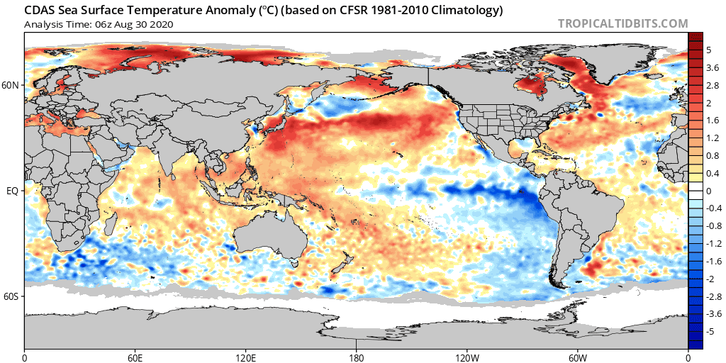
 Sea Surface Temperatures (SSTs)

While Equatorial Pacific SSTs anomalies continue to cool slowly but neutral El NiƱo/Southern Oscillation (ENSO) conditions still exist though I expect to see NOAA declare La Nina by this fall.  Those SST warm SST in the Gulf of Alaska, will bring a change later this fall as well. By promoting more in the way of ridging in the West and more in the way of troughing in the Midwest into the East. The SSTs in the Atlantic are also mostly above average, with the SST along the East Coast well above average.

Years that match up with the current global SST pattern are: 2010, 2013, 2017, and 1970. With 2017 being the closest analog.

 Why has it been so hot?

It's not unusual for the Northeast to see hot temperatures and humid air during the summertime. For the last 4 to 5 months, we’ve been in the same general pattern, while stagnant atmospheric patterns are also not uncommon, the length of this current pattern isn’t unheard of but it is more unusual.

 There are several reasons for the hot and humid conditions we’ve had since June. El Nino began to develop in the fall of 2018, during the first 6 months of 2019 we were in an El Nino Modoki (which is when the warm SST and enhanced rainfall is around the date line, and not in the eastern Pacific closer to Peru. During the 2nd half of 2019 the El Nino Modoki ended and over winter of 2019-2020 we were in ENSO neutral (which is neither El Nino or La Nina).  Neutral ENSO conditions continued during Spring into Summer 2020. Then during the Summer 2020 we began the change to La Nina.  I’ve been saying on my Facebook weather pages, that we’re now rapidly approaching La Nina conditions in the Pacific.   A large change in ocean surface temperature from west to east over late Fall through Winter, can be a sign that the following summer will be hot. We went from a Modoki to near La Nina conditions in short order. This allowed for strong high pressure over North America, which combined with the influence from the developing La Nina. Causing a dome of heat over the eastern 2/3rds of the CONUS.  

Another reason is those much warmer than average SST off the East Coast. They have helped boost the daytime temperatures, and especially the overnight lows. You can blame all that extra water vapor for that.

The Madden Julian Oscillation (MJO)

This Summer the MJO has been mainly propagating through phases 8, 1, and 2. MJO phases 8 and 1 typically place more in the way of troughing in the Gulf of Alaska and ridging across the eastern 2/3rds of North America.  During hurricane season phases 1 and 2 are when conditions in the Atlantic Basin are most favorable. They also favor higher heights and ridging over the Northeast. This is another reason we’ve been warm over the summer. It is also the reason for all the tropical activity in the Atlantic Basin. We saw the MJO in the tropical active phases as the MJO traveled through phases 8 and 1, which resulted in Marco and Major Hurricane Laura in the Gulf of Mexico.

 OK what about Fall into Winter 2020?

Over the fall we should be in La Nina, with the MJO circulating into a more amplified phases 3,4, and 5. This setup will be with us as we transition through Fall into winter 2020-2021.

September, I continue to think we will see hotter than average temperatures overall. The first half of the month could feature more 90+ degree days for some of us. During the 2nd half of the month the odds for those kinds of temperatures does fall off with respect to seasonal averages.

October, the month as a whole should also see overall above average temperatures. But as we get into the 2nd half the overall trend should be slightly cooler, but still most likely slightly above average with respect to seasonal averages.


Here is a look at the SST and surface temperature anomalies from the 4 years I’ve indicated as analogs.

Current 2020


2017


2013


2010


1970


2020 has seen the MJO act similar to what it did in 2010

So here is a blend of temperature anomalies for 2017 and 2010


As far as precipitation, that is going to be difficult to ascertain. But with the pattern as it is. The Mid Atlantic and Northeast are still extra susceptible to tropical impacts.  So, I think overall precipitation will end up average to above average by the end of November.

Snow will be later than normal in showing up. But with the La Nina induced storm track, if we see any polar or arctic outbreaks, those down wind of Lake Erie and Lake Ontario could end up with some lake effect snow out of it.  

Combining the idea of a La Nina Fall and Winter, the MJO wanting to stay in those warm phases, along with those warm waters off the East Coast. The idea of a warm Fall and potentially warm winter is a good bet IMO. For October and November, the La Nina could create an active storm track across the Midwest, Great Lakes into at least part of the Northeast.  All of this will make many across our region feel like they’re on a rollercoaster as we move though Fall. Over the late Fall into the winter the MJO is going to want to try and stay in Phases 3,4, and 5. Which isn’t the greatest news if you don’t like warmer winters. The Mid Atlantic tends to not see tons of snow during La Nina winters. But things can and most likely will change between now and December. 


I will be working on my winter outlook over the next 4 weeks. As I have in past years I will most likely release it in 3 parts…..


Tuesday, August 25, 2020

Can two tropical cyclones merge to become a much bigger storm?


Laura and Marco are generating a lot of attention; not only about their development and track; but also, about what could happen to Laura and Marco if they meet and merge?


The press has been talking about it, many times not correctly. Social Media is flooded with talk about them becoming a giant hurricane, which is not true. It’s true there have never been two hurricanes in the Gulf at the same time; there is a good reason for this and that has to do with the size of the Gulf and available energy. While the Gulf of Mexico is very large, it’s small when talking about oceans. The gulf is about 930 miles wide. So, two hurricanes would have to stay well away from each other (like on opposite ends of the Gulf) If they were closer, they might compete for energy resources and kill off one or both of them. Being that far west or east would make for a lot of land interaction, which would be very detrimental for a hurricane to survive. While Marco’s and Laura’s tracks overlap in the Gulf possibly making landfall within miles and around 24-48 hours of each other, this doesn’t mean a super hurricane is going to happen.

As far back as the record goes, there hasn’t been two hurricanes in the Gulf of Mexico at the same time. But that doesn’t mean there haven’t been two tropical cyclones in the Gulf at the same time. In early September of 1933, two hurricanes were tracking toward the U.S. -- one dubbed the 1933 Cuba-Brownsville Hurricane (Hurricane 8) in the Gulf of Mexico headed toward Texas and the other (Hurricane 11) near the Bahamas, the Treasure Coast Hurricane, tracking toward the east coast of Florida. On Sept. 4, the Treasure Coast Hurricane made landfall as a Category 3 near the border of Palm Beach and Martin counties in Florida at the same time, the Cuba–Brownsville hurricane was slowly tracking toward Texas. Here is an old U.S. Weather Bureau weather map that shows this (courtesy of Philip Klotzbach). The storms made landfall within 24 hours of each other, But the Treasure Coast Hurricane weakened to a tropical storm over Florida before entering the Gulf. The other time was on June 18, 1959, during a brief time there were two tropical storms spinning over the Gulf simultaneously. One was Tropical Storm Beulah, the other was a newly formed tropical storm that would later develop into Hurricane Three.


Anyway, back to 2020, the year of the strange and unexpected….

Here is my latest answer on the idea of these two merging….

Laura and Marco won't as you say merge and combine forces to form a single larger and more powerful storm.

There are three scenarios that occur when tropical cyclones get close to each other. By close I mean within 190 miles of each other. That spacing will be hard to do in the Gulf, given it’s about 930 miles wide. But that be as it may.

The first scenario is, if they are around the same strength, and if Laura and Marco come in close enough proximity, they will dance and rotate counterclockwise around a common midpoint, otherwise known as the Fujiwhara effect. I covered the Fujiwhara Effect a couple of weeks ago during Friday weather school.


The second scenario is, if you have two hurricanes of the same relative strength in close proximity, then their respective sinking air can weaken both storms simultaneously.


The third scenario is, if one tropical cyclone is significantly stronger than the other tropical cyclone, then the weaker of the two can rotate into the stronger storm and weaken even more as it does so. The larger tropical cyclone absorbs the leftover moisture from its dying counterpart, though this absorption could make the parent larger, it does not make the larger parent storm any stronger.


So if any of y’all are thinking Category 6 out of some kind of collision, don’t hold your breath.

Friday, August 14, 2020

The Coriolis Force (also called the Coriolis Effect)

The Coriolis Effect is named after 19th-century French engineer-mathematician Gustave-Gaspard Coriolis. In 1835 he expanded on Sir Isaac Newton’s 3 laws of motion; by describing how an inertial force acts upon things with in a rotating frame of reference. This force is to the right of the direction of body travel for counterclockwise rotation of the reference frame or to the left for clockwise rotation. 

It affects weather patterns, it affects ocean currents, and it even affects air travel. The Coriolis Effect makes things (like planes or currents of air) traveling long distances around the Earth appear to move at a curve as opposed to a straight line. This is the reason; air tends to rotate counterclockwise around large-scale low-pressure systems and clockwise around large-scale high-pressure systems in the Northern Hemisphere. In the Southern Hemisphere, the flow direction is reversed. .


Most of us can agree that the Earth is a very large round object that is rotating on its axis. We can also agree that a day is the length of time it takes the Earth to make one rotation on that axis, which is 24 hours. If this is true, then depending on latitude parts of the Earth are moving at different speeds. 

That might sound crazy, but think of it like this. If one of y’all were standing a foot to the right of the North Pole, this would make the circumference of that circle about 6 feet. It would take 24 hours for that spot to rotate back around that circle on a round rotating Earth. That’s about 0.00005 miles per hour. OK now we move and stand on the equator. The day is still 24 hours long; but the circle circumference is much bigger. At the equator the Earth's circumference is about 25,000 miles. Which would mean you’re moving about 1040 miles per hour just by standing there. So even though we are all on Earth, how far we are from the equator determines our forward speed. The farther we are from the equator, the slower we move. 


Okay how does this stop things like hurricanes from moving in a straight line? Going back to our imaginary surroundings. This time we’re moving at 70 mph down the interstate. As we move, we come up on a slower moving bus. As we pass the bus, we see an open window. Since you have a baseball in your hand, you decide to try and throw that ball through the window. You take aim, and make an extraordinary dead on throw. But in spite of that, the baseball travels to the side and misses the window. That’s because the ball is traveling not only in the direction of the window, but it is also going in the direction (and speed) of your car. And that’s the deflection we are talking about! 

Anything traveling long distances, like air currents, ocean currents, even hurricanes and airplanes, will all be deflected because of the Coriolis Effect! Uncanny but weirdly true. 

 Hope this clears some of the confusion up.

Friday, August 7, 2020

Rain VS Showers


What the heck is the difference between the terms Rain and Showers.

When you hear or see showers on the forecast do you think, there won’t be very much and when you the term rain is used do you think, it will be soaking?

The difference between the two is kind of tricky and subtle. There is no doubt that showers are indeed rain. Taking at face value the term rain or showers, has nothing to do with how much precipitation is going to fall. Instead it tells you how it is going to fall. It has to do with the type of cloud they come from.

What are showers?

A shower is a short duration event, that can last a couple of minutes to perhaps 15 minutes or so. But they can sometime last over half an hour. They typically start quickly and end quickly. There can be heavy downpours when dealing with showers.

Showers come from Cumuliform clouds - Cumulus or Cumulonimbus (thunderstorm) the puffy ones that look like they are bubbling up. often separated by blue sky. Showers are pushed around by the wind, so you only experience a particular shower if you are in its path Since they are hit and miss, your house could be getting wet, while your next-door neighbor could be dry. Cumulus normally result in lower totals while amounts can get quite high from Cumulonimbus.

The customary way of talking about them is isolated showers or scattered/widespread showers. Because they are hit and miss you will never see 100% chance of showers.

Cumulus 


Cumulonimbus


Cumulonimbus


What is rain?

Rain is a moderate to long duration event. That can last for a couple of hours to all day. It typically starts gradually then ramps up and ends gradually.

Rain comes from Stratiform clouds- Altostratus and Nimbostratus. These types of clouds are more or less featureless and cover the sky in a grey, widespread sheet, with little to no blue sky to be seen, and of the two, Nimbostratus is thicker and produces heavier rains.

Rain covers a wide area, so most or everyone over a large area are getting wet. Rain can come down lightly or heavily. Because of its long-lasting duration, it can lead to flooding issues.

Altostratus 

Nimbostratus


Well if some of y’all were confused by the two terms, I hope this clears it up.