In my post "The Tornado" I said, gustnadoes are short lived vortex's of wind that can form in front of a thunderstorm. you can read more at this link.
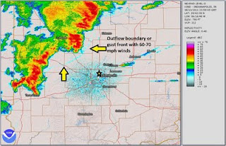
There is a definite possibility it was a gustnado, Just prior to the stage collapse, gustnadoes were spotted in the Indianapolis area and captured on video. However, downburst and gust fronts can cause dirt and dust to behave like it did in the video. In fact, radar showed an outflow boundary (gust front) caused by collapsing thunderstorms about 3 - 4 miles ahead of the severe thunderstorm complex.
Link to a radar loop that shows how things looked when the storm pulled through. You will need Quicktime to view it.
These pictures taken by Ernie Mills show the sequence of failure.
The point I'm trying to make here is it doesn't matter if it was a gustnado or straight line winds that caused this horrible accident. My point is, severe weather can strike quickly. You have to be aware of weather that's heading your way.....you can't always wait for experts or officials to tell you what to do; you have to be ready and willing to take your family's safety in hand. Reading things like my blog series on severe weather awareness will help by giving you the knowledge you need to make good decisions.
Rebecca Ladd


Andy, I've been reading your blog for the last 18 months. However, I now see how important it is to know about weather heading my way. I want to say thank you for taking the time to write about weather awareness.
ReplyDeleteCould it have been a tornado?
ReplyDeleteNo it wasn't a tornado, it was straight line winds......If you notice the flag in the center of the picture; you will see it is always blowing away from the thunderstorm
ReplyDelete