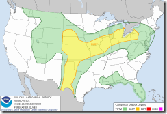
Often when severe weather is anticipated, meteorologists will sometimes assign a level of risk to an area for the likelihood of severe weather.
The risk may be Slight, Moderate, or rarely High. Meteorologists will refer to an area having a certain "risk" of severe weather.
When severe weather is likely, most weather outlets will minion the Storm Prediction Center (SPC), located in Norman, Oklahoma. The SPC is part of the National Weather Service (NWS) and the National Centers for Environmental Prediction (NCEP).
I've been inside the SPC many times (if you ever get the chance I encourage you to visit). The building is shared with several weather centers including the National Severe Storms Laboratory, The National Severe Storms Forecast Center, and the University of Oklahoma School of Meteorology.
The Severe Storms Forecast Center is responsible for tornado watches and other thunderstorm watches. (Warnings come from each NWS office)
Some of the products the SPC is responsible for are:
Forecasting for fire weather (conditions favorable for wildfires) in the contiguous U.S. which are Day 1, 2, and 3–8 fire weather outlooks.
Issuing mesoscale discussions, are issued to give information on a region that is becoming a severe weather threat and states whether a watch is likely and details thereof, as well as situations of isolated severe weather when watches are not necessary.
General severe weather outlooks.
Convective outlooks, which give detail on the risk of severe weather. Since this post is about convective outlooks; I will go into more detail on this Convective outlooks are issued for Day 1, Day 2, Day 3, and Day 4–8, and detail the risk of severe thunderstorms and tornadoes during the given forecast period, although tornado, hail, and wind details are only available for Day 1. Days 2 and 3, as well as 4–8 used a probabilistic scale, determining the probability for a severe weather event in percent.
Risk categories:
Three risk categories (SLGT, MDT, and HIGH) stand for the coverage and intensity of organized severe weather such as supercells, squall lines, multicell thunderstorm complexes, and of course tornadoes.
what is not included in the three risk categories.
Garden variety (pulse type) thunderstorms, which can contain brief severe updrafts.
Isolated (random) severe storms with marginal intensities or short durations of severe weather.
SLIGHT RISK (SLGT):
A SLGT risk is issued frequently during the severe weather season and implies well-organized severe thunderstorms are expected, but in small numbers and/or low coverage. Typically, SLGT Risk areas produce scattered severe weather, including scattered wind damage or severe hail and possibly some isolated tornadoes.
MODERATE RISK (MDT):
This isn't issued as frequently as a Slight Risk area. Its reserved for days when substantial severe storm coverage, or an enhanced chance for a significant severe storm event. A MDT Risk implies a greater concentration of severe thunderstorms, and in most situations, greater magnitude of severe weather. When a MDT risk is issued the forecaster has a much greater confidence that a widespread severe event will occur (as compared to a Slight Risk.) Typical Moderate Risk days include multiple tornadic supercells with very large hail, intense squall lines with widespread damaging winds, or in some cases, land-falling tropical storm systems.
HIGH RISK:
A HIGH risk area suggests a major severe weather outbreak is expected, with the expectation of either a concentration of strong tornadoes or an enhanced likelihood of a long-lived wind event (derecho) with the potential of higher end wind gusts (80+ mph) and structural damage. The High Risk category is reserved for the most extreme events with the least forecast uncertainty, and is generally only used a few times each year.
For all outlooks, the probability values represent the chance of severe weather occurring within 25 miles of any point, which is about the size of a major metropolitan area.
As an example, if you are in a 15% probability for tornadoes, this means you have a 15% chance of a tornado occurring within 25 miles of your location.
Other things to know about the convective outlook:
The unlabeled (brown) thunderstorm line on the outlook graphic depicts, to the right of the line, a 10% or higher probability of thunderstorms during the valid period.
Sometimes, a blue hatched area will be overlaid with the severe probabilities. Blue hatching means a 10% or greater probability for significant severe events within 25 miles of a location in the area.
"Significant" is defined as:
Tornadoes rated EF2 or greater,
Thunderstorm wind gusts of hurricane force or higher--65 kt or 74 mph;
Hail 2 inches or larger in diameter.
On days when the forecast severe-storm threat is not organized enough or is too conditional for a SLGT risk, but marginal threat still exists, a SEE TEXT label will be placed on the graphic where a 5% severe probability exists.
The Day 4-8 outlook is a single graphic and short narrative covering well-organized severe-weather potential 4-8 days out. There is no general thunder forecast, significant-severe area or SEE TEXT because of the long time frame and uncertainties involved. Each line represents a 30% probability area for a day, or the same as an "enhanced slight risk" on day-1. If the threat looks lower than 30%, "POTENTIAL TOO LOW" will appear. If the threat might exist, but is too unclear to draw a specific area, "PREDICTABILITY TOO LOW" is the label. The lack of a line does not mean that a severe threat is absent--just that the threat is too low, disorganized or uncertain for a 30% area that far out in time.
Well that is it... I hope this sheds some light on this subject.....
Rebecca


