Friday, September 11, 2026

It's nice for now!!!

 I got back from the 9/11 ceremony and decided to get this post out to All Y’all

Surface Chart, Radar and Satellite


Today

 We have a cold front slowly sinking south and east away from the region. Other than a few showers over Maryland, Delaware and southern New Jersey, the region is mostly sunny and dry, with seasonally cool temperatures.  

We have high pressure building in, that will ensure the region remains dry into tomorrow.

The weekend

On Saturday a warm front will be lifting into the region, winds will become which will bring warmer air into the region. The region looks to stay mainly dry during the morning, but rain showers will be lifting north into Maryland, Delaware, New Jersey and southern Pennsylvania during the afternoon. These showers look to reach New York State and southern New England Saturday evening, then reaching central and northern New England during the overnight. Some of the rain could be heavy at times, especially the farther south you are.  A rumble of thunder is possible as well.  With the front warm and muggy air will move into the region south to north.

a cold front will slowly approach Saturday night and move through west to east on Sunday. There could be some rain and thunderstorms across western parts of the region during late morning. But the rain and thunderstorms will be moving east during the afternoon into Sunday night. Some of these storms could be strong to severe.


The Storm Prediction Center has outlined most of Pennsylvania, New York State into western New England at a Marginal Risk for isolated severe thunderstorms Sunday. The main threat will be strong damaging winds and localized heavy downpours. We will have to be on the lookout to see if a wave of low-pressure forms along the front, which could enhance rain amounts.

Next Week

 Monday is mainly dry but there could be some lingering rain over eastern New England.  Tuesday we will have a frontal system approach; this will keep the region unsettled for Tuesday through Thursday.

Tropics

It’s been a while since I said anything about the tropical Atlantic, but to be fair, there hasn’t been anything to talk about.

We have a couple of tropical waves over the Caribbean and two others over the tropical Atlantic, with a few more behind them.  But other than that, there is nothing going on!


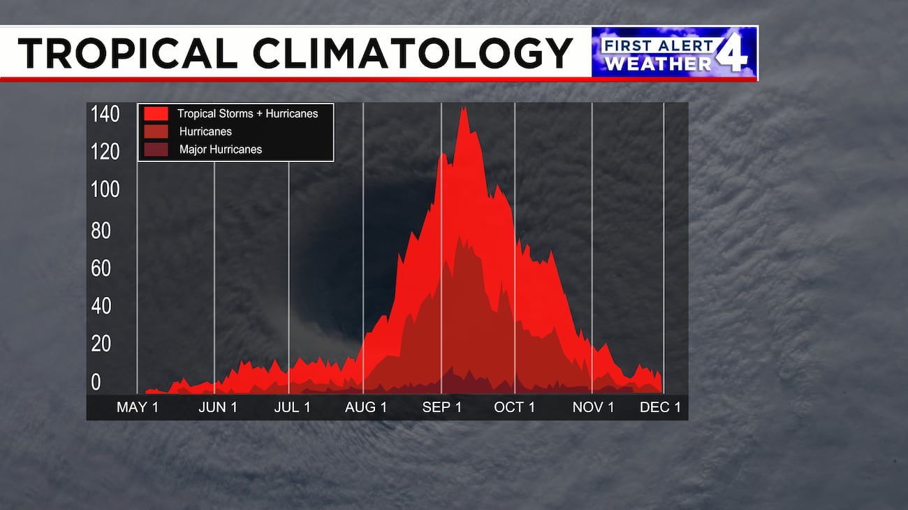
 We’re at the peak of the Atlantic Hurricane Season and it is remarkably quiet. During the satellite era, the Atlantic hurricane season has never gone beyond September 11th without having a hurricane form. So, we’re in record territory. As I’ve said many times, overall seasonal activity as measured by the Accumulated Cyclone Energy or ACE is a measly paltry 4.4 units (the average for this point in the season is 60.3 ACE units), the lowest of any hurricane season to date in the modern record.


Wind shear and dry air still dominate the Atlantic Basin, so I don’t see anything developing for the foreseeable future. It’s possible we could go all through September without seeing a hurricane.

Never Forget!

Have a great weekend! 


Thursday, September 10, 2026

A nicer stretch of weather is ahead

  Parts of the region will be unsettled today, but a couple of nice days will follow.

Surface Chart and Radar


Satellite 


Today

We have a cold front and trough working through the region.

New York State, Pennsylvania and most of New England will be seeing ample sunshine and slightly below average temperatures with lower humidity. But an upper-level disturbance up in Canada may cause a few isolated showers for northern Maine this afternoon. The showers and storms are continuing to slide south. By this evening, storms will become abundant, some of these storms could be strong to severe. Later this afternoon and into tomorrow morning, there will be the chance for strong winds and isolated areas of moderate to perhaps heavy rainfall. The Storm Prediction Center has a Marginal Risk across Virginia, southern Maryland and Delaware.  


The rest of the week

Behind the front heading toward Friday afternoon, Southern Pennsylvania and the rest of the Middle Atlantic will see mostly sunny skies, slightly below average temperatures and lower humidity as high pressure sits overhead. With mostly clear skies it will turn quite chilly for tomorrow evening and overnight.   Saturday will see a cool start, but a warm front advance into the region, allowing warmer above average temperatures and humid air to move back in overhead, the farther south you are the higher the dewpoints will be.


Looking at the surface chart we can see another cold front approaching the Midwest. This will move along a stalled front and impact our region late Saturday and Sunday, bringing the risk for showers and thunderstorms moving west to east. I think most of the thunderstorms will stay non severe, but a few isolated storms could become strong to severe, with the chance for gusty winds and embedded downpours.

Next Week

For Monday thru Wednesday will see mostly clear sides with temperatures staying below average and humidity staying low.  The high pressure will be sliding east later Wednesday, as a trough and frontal system approach the region.

 Drought Outlook

Parts of the region saw heavy rain, other didn’t. Parts of far northern New York, southwest New York, Pennsylvania, northeast West Virginia, New Jersey and Delaware. The rain led to some improvements in the drought and abnormal dryness in Pennsylvania, West Virginia, Maryland, Delaware and New Jersey and parts of New York State (Tug Hill) and southern Rhode Island.  

The U.S. Drought Monitor released earlier today showed 5% of New York and New England in severe drought, 25% in moderate drought, and 27% as abnormally dry compared to 4%, 20%, and 30%, respectively, last week. Any of Y'all noticing impacts from dry conditions in your area?


Have a great Thursday


Wednesday, September 9, 2026

Showers and storms return.


The last few days have been great, but showers and storms are back for today into tomorrow.

Surface Chart and Radar


Today

We have high pressure sitting off the northern Middle Atlantic Coast, with the stationary front sitting over eastern New York State, with a prefrontal trough and low pressure approaching from the west. Ahead of this, we have a warm front lifting northward with a southwest flow that is directing warmer temperatures and much higher humidity into the region, making it feel quite muggy. We have a few showers ahead of and along the prefrontal trough. But the showers and storms should become more widespread later this afternoon into 10 to 11 p.m. Some of these storms could be strong to severe. The Storm Prediction Center has a Slight Risk for Severe Storms across Western Pennsylvania into Southwest New York State.  With a Marginal Risk across much of Northern Pennsylvania into Central New York State.


The greatest chance of severe thunderstorms will happen during the later afternoon into this evening. The main threat will be damaging winds and heavy downpours, but there is a very low risk for a tornado or two, SPC has outlined northwest Pennsylvania and southwest New York State at a 2% chance.

The rest of the week

 A few showers may linger across northern areas into Thursday morning, before things dry out, But the widespread showers and a few thunderstorms will move over Southern New England eastern Pennsylvania, Maryland, Delaware and New Jersey as the cold front finely moves through.

Outside of the chance for lingering showers over southern New Jersey, Maryland and Delaware early Friday morning, things should dry up, leading to a fairly nice rest of Friday.  Friday and Saturday should see coolish temperatures with low humidity as high pressure sets up.  Both days should be mainly dry. Then the high pressure will depart and a cold front approach for late Saturday and moves through on Sunday, the front will bring rain showers and a few thunderstorms, some of the showers could be heavy at times.

Monday will see high pressure move back-in overhead, providing near seasonal temperatures and dry conditions. Then on Tuesday a warm front will be lifting into the region, allowing temperatures and dewpoints to climb.  Later Tuesday and Wednesday a cold front will roll through, bringing scattered showers and thunderstorms, some of these storms could be strong to severe.  


Tuesday, September 8, 2026

Weekly El Nino Update


Today the Climate Prediction Center / NCEP released this week’s El Nino update.


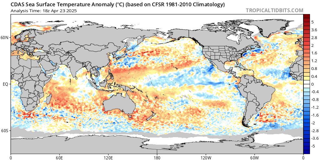
Global SST Anomaly


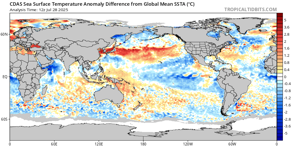
SST Anomaly mean difference


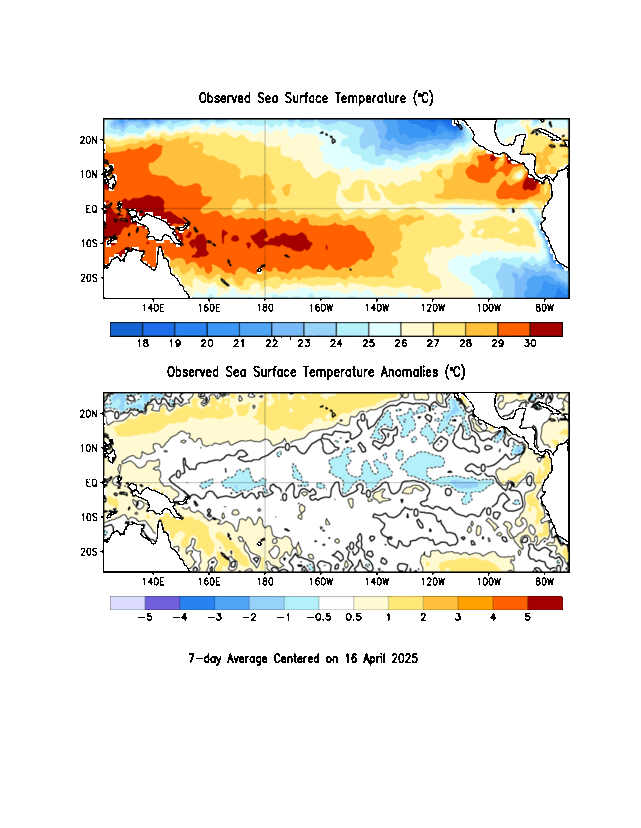
Current Conditions.   


SST Anomaly Analysis


As of today’s update, the Nino region SST departures are Nino 4 0.1 °C, Nino 3.4 1.8°C, Nino 3 2.7°C and Nino 1+2 is at 3.9°C. While the Central equatorial Pacific seems to have leveled off; the Eastern equatorial Pacific continues to get warmer.


National Oceanic and Atmospheric Administration’s (NOAA) Weather Prediction Center (WPC) El Nino is strengthening, and still says there is a greater than 90% chance of a very strong event during the Northern Hemisphere fall and winter 2026-2027.

 El Nino is expected to continue strengthening through at least the end of this year.

 For the US Southern Tier and the Southeast US this means a strong and very active subtropical jet stream will form by late fall, with frequent fronts, severe weather, and weekly rainfall and above-average temperatures in parts of the northern tier during fall.

The Atlantic Basin has been seeing a strong impact, with strong upper-level winds leading to extreme wind shear limiting Atlantic storm development. The 2026 season is off to its least active start in at least 60 years, continuing to struggle to produce even one well-organized storm. Even though we're in the heart of the season there hasn’t been an hurricane yet for the season.  Of the five named storms that have formed this year illustrate the pattern rather than break it. Each reached tropical storm strength. But due to the strong shear, dry and dusty air sinking over the tropical Atlantic preventing storms to really get their act together.  It is thought that there have been two seasons with zero hurricanes: 1907 and 1914. But since that was before the satellite era, there is no real way to know if that is true or not, due to storms that never reached land or being reported by ships. 


SST Anomaly mean difference


That’s it for this week


Another great day!

 I hope all y’all had a great Labor Day weekend.

Sunshine and low humidity continues in the Northeast and Northern Mid-Atlantic states into Wednesday. The next cold front arrives later Wednesday and Thursday with the risk for showers and thunderstorms.

Surface Chart and Radar


Today

Another quiet, beautiful weather day is in store for the vast majority of the region, with a mix of sun and clouds. Those with the best chance of seeing isolated rain showers will be mainly across northern portions of the region, due to a backdoor frontal boundary, but this will be the exemption to the rule and these showers should be short-lived with little in the way of rain. That backdoor cold front will stall out and a southwest flow will mean warmer and more humid air will surge north into the region for the next couple of days.

We can see a disturbance over the Upper Great Lakes and Midwest. This disturbance is associated with the stronger cold front that will be approaching tomorrow.


The rest of the week

Tomorrow will start out similar to today. But a cold front will drop in late Wednesday and Thursday. There could be a few isolated showers Wednesday morning for western and northern parts of the region, but the bulk of the rain will start to move in during the afternoon moving north to south. Along with the rain showers there will likely be scattered thunderstorms, with the threat for isolated storms to become strong to severe. The Storm Prediction Center has outlined western and northern Pennsylvania along with western into central New York State at a Marginal Risk for Severe Thunderstorms Wednesday afternoon and evening in which some strong damaging wind gusts will be the primary risk…But small hail and heavy rainfall will also be an issue. Locally heavy downpours may result in some flash flooding and poor-drainage flooding.


The front will slowly work from north to south cold on Thursday, while conditions will be clearing north of the Boundary, those along and south of the boundary will be seeing mostly cloudy and a humid day. With the front will come the risk for scattered showers and a few thunderstorms mainly during the afternoon and evening. The day doesn’t look to be washout, with things clearing up late Thursday into Friday morning. Pennsylvania, Maryland, Delaware and New Jersey will have a very low chance for strong storms, but with the higher humidity, there could be a few heavy downpours leading to the threat for some localized flooding.


Friday will see high pressure build in, producing clear skies and low humidity and cooler temperatures. Saturday is looking to be a mostly great day, but I can’t rule out the threat for a few isolated showers over southwest Pennsylvania.  Sunday the high pressure will be starting to depart, as a cold front approaches from the west and north. Out ahead of the front conditions will become a bit muggy. The front will make things a bit unsettled, but I don’t think the rain will amount to much. High pressure builds back in for Monday, providing sun and mostly dry conditions.  The high pressure will stay in control for Tuesday, both Monday and Tuesday will see fall-like temperatures with lower humidity


Monday, September 7, 2026

A tranquil Labor Day!

 Today is going to be a near perfect weather day. There will be plenty of sunshine, along with comfortable temperatures and humidity levels.  So, enjoy your cookouts and all of your Labor Day plans.


Today

Today is going to be a near perfect weather day. There will be plenty of sunshine, along with comfortable temperatures and humidity levels.  So, enjoy your cookouts and all of your Labor Day plans.

The rest of the week

With the exception of a few showers across the far Northern parts of the region, Tuesday will be a near copy of today with a mostly dry day and a mix of sun and clouds.

Wednesday that high pressure dome will have expanded across the southern Plains into the Southeast. Then we’re going to have a large area of low-pressure scoot across southern Canada toward Quebec. The cold approaching cold front will be slowing down and likely become quasi-stationary.  The high pressure will be slipping off the coast. Out ahead of the front, the southwest flow will allow temperatures and dew points to start increasing, along with the chance of showers and storms. Isolated rain showers could reach western and parts of northern New York State and northern New England on Wednesday afternoon. As that cold front gets closer, more in the way of significant rain and scattered thunderstorms will be likely across New York State, and northern and central New England New England on Wednesday night into Thursday, for northern parts of the region this will be a soaking rain, and good news for those areas needing the rain. That northwest flow associated with the front, could set off a few stronger thunderstorms.

As the front continues to slowly drop south and east on Thursday, it will weaken, as the front drops into southern New England the rest of Pennsylvania, Maryland Delaware and New Jersey, it could wash out. Allowing any scattered rain showers to become more isolated. There will be the chance for a few isolated thunderstorms as well.  The rain won’t amount to all that much, so the areas under the front, won’t see much in the way of beneficial rain.  By Friday the front should have pushed to our south.  Behind it fall like temperatures and lower humidity will setup. Daytime temperatures will be slightly below average to average for this point in September, and the nights will be very cool. With high pressure over the region, we should see a mix of sun and clouds and mainly dry conditions for Friday into the weekend.

Don’t let the cool fall weather fool you, I don’t think we’re done with shots of warmer weather along with the chance for severe weather days.


Sunday, September 6, 2026

Quick overview of this week!

The start of the Labor Day Weekend was wet for some and dry for others, but overall, it wasn't too bad but a bit cool.  The pattern will be splendid as we move forward for the next couple of days, but big changes are on the way.

Looking at the 500mb heights we can see troughing over the Pacific Northwest and the Northeast, with that persistent high pressure ridge out over the Plains. 


Images courtesy of Tropical Tidbits

By Wednesday that ridge across the center of the U.S., will have pushed east. 

Image courtesy of Tropical Tidbits

Surface Chart and Radar


Today

 Temperatures are still seasonally cool, but conditions are mostly dry. But we do have that upper-level-low in the Canadian Maritimes, spinning in some clouds and isolated showers back over eastern Maine.

Tonight, will be very cool for early September, with the region dropping into the 50s°F and 40s°F But temperatures in the higher elevations like the Tug Hill, Adirondacks, Greens and Whites will make it into the mid to upper 30s°F

The rest of the week

Tomorrow that high pressure sitting north of the Great Lakes will push east and push that ULL out of here, allowing for the Sun and fabulous weather currently over New York State and Pennsylvania to push into the rest of New England.  Leading to a fantastic Labor Day Monday for all y’all.

For Tuesday ahead of a frontal system, we will see cloudiness start to move in. Our Temperatures will be slightly below average to average. The same general conditions for the first part of Wednesday but then a few showers will be working in the afternoon over western parts of the region these will be working south and east during the day making it into eastern New England Wednesday night into Thursday, as that area of low-pressure system moves across Canada. region. The leading warm front will allow warmer temperatures and higher dewpoints into the region, as that high pressure ridge pushes toward the Southeast U.S. Wednesday and Thursday will be warm and somewhat humid. But the warmest temperatures will be over Pennsylvania, Maryland, Delaware into New Jersey.  Along with the warmer temperatures will come the chance for scattered rain showers and thunderstorms, although rain amounts don’t look to amount to all that much at this time.  For Wednesday into Friday winds will become gusty, with gust up to 25-30 mph possible.

Later Thursday and Friday will see a cold front approach and move through the region, with high pressure building back in from the north and west, allowing Friday and the coming weekend to be mostly dry, much cooler and less humid.

Over the coming weekend it will feel like Fall. But I still think overall temperatures for the month of September, will end up slightly above average. 

I've edited and added some more confirmed tornadoes to the Friday post.


Friday, September 4, 2026

An overall nice Labor Day Weekend!


The Northeast will have an overall nice weekend, but it will be a touch cool.  Also, there will be a few passing showers or thunderstorms for some of y’all across the region.


Surface Chart and Radar


Today

As the cold front slides slowly south and out of the region, the showers and storms should be across Southern Pennsylvania and Central and Southern New Jersey and points southward. The farther north you are the more sun you will see. The NWS Storm Prediction Center has southwest Pennsylvania, Maryland, Delaware, into New Jersey at a Slight Risk for the possibility of isolated severe thunderstorms. Strong, damaging wind gusts (Wind could gust above 70 mph) and heavy rain will be the primary hazard within these storms, though isolated hail, frequent lightning. With the heavy downpours localized flash and urban flooding is very possible.


 The Holliday Weekend

Things are looking to be mostly dry Labor Day weekend with slightly below to seasonal temperatures and lower humidity. But we will have an Upper-Level-Low sitting south of Atlantic Canada. The trough will see weak disturbances rotate around the ULL, bringing the chance for very isolated brief showers. But most of the time from Saturday through Monday the region should be dry. Those will the best chance of seeing these showers will be in New England

Next Week

A front dropping out of Canada will pass through Monday night and Tuesday. This will bring scattered rain showers during the overnight into Tuesday. We will also see cooler temperatures move in as well. Then on Wednesday high pressure will setup briefly as a cold front approaches the region. The cold front will slide through on Thursday producing scattered showers and thunderstorms. 

The September 2nd severe outbreak


Image curtesy of Aaron Gillies

A mothership supercell moved through Western New York, producing six tornado warnings and widespread wind damage.  The name come from the massive, rounded, lowhanging cloud base and distinctive layered, UFOlike appearance.

The National Weather Service storm dispatched survey teams on Thursday to assess damage caused by severe thunderstorms and have so far confirmed 8 tornadoes.

NWS Binghamton confirmed an EF1 near Waterloo in Seneca County, NY. It had max winds of 95 mph with a track of between 6 and 7 miles with a max width of 250 yards.

 the other confirmed by Binghamton was an EF2 tornado near Fayette also in Seneca County. It had winds up to 115 mph and tracked 7.76 miles with a max width of 200 yards. 

NWS Buffalo confirmed an EF-1 tornado in Medina, in Orleans County, NY. It had estimated winds of 105 mph and tracked 1.20 miles with a max width of 200 yards.

Another confirmed tornado by Buffalo was an EF-1 east of Alexander in Genesee County, NY. It had estimated winds of 110 mph and tracked 3.78 miles with a max width of 150 yards.

Buffalo confirmed an EF-1 tornado in Olcott, NY, in Niagara County, NY. It had estimated winds of 105 mph and tracked 0.67 miles with a max width of 70 yards.

EF-1 tornado was confirmed by Buffalo in Castile, in Wyoming County, NY. It had estimated winds of 105 mph and tracked 1.22 miles with a max width of 300 yards.

EF-1 tornado was confirmed by Buffalo in Castile, (near Letchworth State Park) also in Livingston County, NY. It had estimated winds of 110 mph and tracked 1.25 miles with a max width of 130 yards.

NWS Buffalo confirmed an EF-1 tornado in Webster, in Wayne County, NY. It had estimated winds of 105 mph and tracked 3.23 miles with a max width of 130 yards.

Both offices also confirmed several microbursts.

I expect more data and information to be released today. 

Drought Outlook


Looking at the side-by-side map, conditions continued to improve in the Mid-Atlantic Region and southern New England but deteriorated over parts northern New England and sections of upstate New York State. The good news is that we can see extreme drought was erased from the Northeast and severe drought was removed from New Jersey, while moderate drought and abnormal dryness shrank in the region’s southeastern corner. However, severe and moderate drought expanded in Maine, while abnormal dryness grew in coverage in Maine, New Hampshire, and northern into Central and western New York State.

The U.S. Drought Monitor released yesterday showed 0% of the Northeast in extreme drought, 3% in severe drought, 15% in moderate drought, and 25% as abnormally dry compared to less than 1%, 2%, 14%, and 23%, respectively, last week.


Thursday, September 3, 2026

Mesoscale Discussion 2218


Mesoscale Discussion 2218
   NWS Storm Prediction Center Norman OK
   0316 PM CDT Thu Sep 03 2026

   Areas affected...Eastern Ohio into central Pennsylvania...western
   Maryland...and far northern West Virginia

   Concerning...Severe Thunderstorm Watch 649...

   Valid 032016Z - 032215Z

   The severe weather threat for Severe Thunderstorm Watch 649
   continues.

   SUMMARY...Supercells across eastern Ohio and northwestern
   Pennsylvania will likely grow upscale and pose a more substantial
   wind threat downstream into central Pennsylvania through the
   evening. Downstream watch issuance is expected soon.

   DISCUSSION...Discrete to semi-discrete supercells are evident in
   regional radar imagery across northeast OH and northwest PA with a
   few instances of severe hail noted over the past hour. Regional VWPs
   continue to sample elongated hodographs favorable for splitting
   supercells with an attendant threat for large hail for the next hour
   or so. Given the propensity for splitting cells and tight clustering
   of convection, upscale growth into one or more organized lines
   appears probable over the coming hours. As this occurs, the
   potential for severe wind should increase as convection moves into
   central PA where air mass recovery has been ongoing through the
   afternoon (MLCAPE has increased to 1000-1500 J/kg per recent
   mesoanalysis estimates).

   ..Moore.. 09/03/2026

   ...Please see www.spc.noaa.gov for graphic product...

   ATTN...WFO...CTP...LWX...PBZ...CLE...

   LAT...LON   41068148 41388079 41698017 41397732 41157698 40807689
               39967720 39607747 39487796 39527869 40278123 40498158
               40728172 40888169 41068148 

   MOST PROBABLE PEAK TORNADO INTENSITY...UP TO 90 MPH
   MOST PROBABLE PEAK WIND GUST...65-80 MPH
   MOST PROBABLE PEAK HAIL SIZE...UP TO 1.25 IN


Severe Thunderstorm Watch Number 650


SEL0

   URGENT - IMMEDIATE BROADCAST REQUESTED
   Severe Thunderstorm Watch Number 650
   NWS Storm Prediction Center Norman OK
   435 PM EDT Thu Sep 3 2026

   The NWS Storm Prediction Center has issued a

   * Severe Thunderstorm Watch for portions of 
     Western Maryland
     Western and Central Pennsylvania
     Eastern West Virginia

   * Effective this Thursday afternoon from 435 PM until Midnight
     EDT.

   * Primary threats include...
     Widespread damaging wind gusts to 70 mph likely
     Isolated large hail events to 1.5 inches in diameter possible
     A tornado or two possible

   SUMMARY...Multiple rounds of severe storm clusters are expected to
   move into the region from the northwest and impact the region this
   evening, with wind damage as the most common hazard.

   The severe thunderstorm watch area is approximately along and 60
   statute miles east and west of a line from 55 miles northwest of
   Williamsport PA to 35 miles south southwest of Martinsburg WV. For a
   complete depiction of the watch see the associated watch outline
   update (WOUS64 KWNS WOU0).

   PRECAUTIONARY/PREPAREDNESS ACTIONS...

   REMEMBER...A Severe Thunderstorm Watch means conditions are
   favorable for severe thunderstorms in and close to the watch area.
   Persons in these areas should be on the lookout for threatening
   weather conditions and listen for later statements and possible
   warnings. Severe thunderstorms can and occasionally do produce
   tornadoes.

   &&

   OTHER WATCH INFORMATION...CONTINUE...WW 647...WW 648...WW 649...

   AVIATION...A few severe thunderstorms with hail surface and aloft to
   1.5 inches. Extreme turbulence and surface wind gusts to 60 knots. A
   few cumulonimbi with maximum tops to 550. Mean storm motion vector
   31025.

   ...Guyer


Severe Thunderstorm Watch Number 649


 SEL9

   URGENT - IMMEDIATE BROADCAST REQUESTED
   Severe Thunderstorm Watch Number 649
   NWS Storm Prediction Center Norman OK
   300 PM EDT Thu Sep 3 2026

   The NWS Storm Prediction Center has issued a

   * Severe Thunderstorm Watch for portions of 
     Northern and Eastern Ohio
     Western Pennsylvania
     Northern West Virginia
     Lake Erie

   * Effective this Thursday afternoon and evening from 300 PM until
     1000 PM EDT.

   * Primary threats include...
     Scattered damaging wind gusts to 70 mph likely
     Isolated large hail events to 1.5 inches in diameter possible
     A tornado or two possible

   SUMMARY...Storms will continue to increase in coverage and intensity
   across the region the remainder of the afternoon, with the
   development of east/southeastward-moving clusters. This will be
   ahead of what could be a more prominent linear cluster moving
   southeastward into the region out of southeast lower Michigan, which
   could cross northern/eastern Ohio into western Pennsylvania through
   early evening. Damaging winds will be the most concern severe
   concern.

   The severe thunderstorm watch area is approximately along and 85
   statute miles north and south of a line from 50 miles northwest of
   Mansfield OH to 15 miles east northeast of Latrobe PA. For a
   complete depiction of the watch see the associated watch outline
   update (WOUS64 KWNS WOU9).

   PRECAUTIONARY/PREPAREDNESS ACTIONS...

   REMEMBER...A Severe Thunderstorm Watch means conditions are
   favorable for severe thunderstorms in and close to the watch area.
   Persons in these areas should be on the lookout for threatening
   weather conditions and listen for later statements and possible
   warnings. Severe thunderstorms can and occasionally do produce
   tornadoes.

   &&

   OTHER WATCH INFORMATION...CONTINUE...WW 647...WW 648...

   AVIATION...A few severe thunderstorms with hail surface and aloft to
   1.5 inches. Extreme turbulence and surface wind gusts to 60 knots. A
   few cumulonimbi with maximum tops to 550. Mean storm motion vector
   31025.

   ...Guyer


Yesterday was very active.

Yesterday and last night was very active. This was the result of a series of disturbances rotating around that heat dome anchored over the Central Mississippi Valley. There was an earlier round of showers and thunderstorms. These produced a lot of rain. Several inches of rain fell, with storms producing 1-2 inches of rain per hour. Then another stronger disturbance moved across New York State and Pennsylvania. This allowed things to reorganize During the evening a line of severe thunderstorms swept through western-central New York State and north-central Pennsylvania. The line produced widespread damaging wind and frequent in cases near continuous lightning, over 48,000 lightning strikes were observed. As the line pushed through many tornado warnings occurred, there was at least one confirmed tornado, and the NWS survey teams are looking at other areas.  There was a lot of flash flooding due to the training nature of the thunderstorms (storm cells repeatedly tracking over the same areas).   


 Surface Chart and Radar


We can see the cold front is prepared to drop into New York State. This will become semi stationary, with disturbances moving along it, bringing rounds of rain showers and thunderstorms. We can see the disturbance over the Upper Midwest and Upper Great Lakes; this will roll through later today into the evening. Some of these will be strong to severe

Today

The NWS Storm Prediction Center has western Pennsylvania under an Enhanced Risk, with central/southern Pennsylvania, Maryland, Delaware, into New Jersey at a Slight Risk for the possibility of isolated severe thunderstorms. Strong, damaging wind gusts (Wind could gust above 70 mph) and heavy rain will be the primary hazard within these storms, though isolated hail, frequent lightning and a few tornadoes are also possible. With the heavy downpours localized flash and urban flooding is very possible.


Behind yesterday’s storms, the air is very humid, along to seasonal temperatures across New York State and New England. Across Pennsylvania and the Middle Atlantic, the air feels tropical with higher temperatures and humidity.  The tropical air will sag south as the cold front continues to slowly move south.

Stay weather aware, have a way to receive warnings. 

Rest of the Week


Storm chance continues tomorrow, this will be especially true over southwestern Pennsylvania, northern Maryland and southern Delaware. Where the NWS has a Marginal Risk for severe storms. Far southern Maryland and Delaware and points South will be highlighted in a Slight Risk.  The good news is much of this unsettled pattern ends in time for Labor Day weekend. Saturday and continuing into Labor Day Monday, temperatures and humidity levels look to be seasonal, with plenty of dry time. But those troughs will be close by, so a few isolated showers can’t be ruled out.  Tuesday will see a warm front lift into the region allowing temperatures and humidity to start to climb.  The next chance for rain appears on Wednesday, as a cold front approaches and move in over the region.


Wednesday, September 2, 2026

Tornado Watch Number 645


The watch will be in effect until 11:00 PM

The watch means tornadoes are possible in and near the watch area. Think about and go over your emergency plans. Be ready to act quickly if a warning is issued or you suspect a tornado is approaching.

NWS statement

“SEL5


   URGENT - IMMEDIATE BROADCAST REQUESTED

   Tornado Watch Number 645

   NWS Storm Prediction Center Norman OK

   440 PM EDT Wed Sep 2 2026


   The NWS Storm Prediction Center has issued a


   * Tornado Watch for portions of

     Western and Central New York

     Lake Erie

     Lake Ontario


   * Effective this Wednesday afternoon and evening from 440 PM

     until 1100 PM EDT.


   * Primary threats include...

     A few tornadoes and a couple intense tornadoes possible

     Scattered damaging wind gusts to 70 mph likely

     Scattered large hail and isolated very large hail events to 2

       inches in diameter possible


   SUMMARY...Supercell thunderstorms should pose some threat for large

   hail and perhaps a few tornadoes as they move eastward late this

   afternoon and evening across parts of western and central NY. A

   strong tornado appears possible if thunderstorms can remain at least

   semi-discrete this evening. Thunderstorms will likely grow upscale

   into a bowing cluster later this evening, with a greater threat for

   scattered to numerous severe/damaging winds up to 60-70 mph.


   The tornado watch area is approximately along and 85 statute miles

   east and west of a line from 35 miles west northwest of Watertown NY

   to 60 miles east of Jamestown NY. For a complete depiction of the

   watch see the associated watch outline update (WOUS64 KWNS WOU5).


   PRECAUTIONARY/PREPAREDNESS ACTIONS...


   REMEMBER...A Tornado Watch means conditions are favorable for

   tornadoes and severe thunderstorms in and close to the watch

   area. Persons in these areas should be on the lookout for

   threatening weather conditions and listen for later statements

   and possible warnings.


   &&


   OTHER WATCH INFORMATION...CONTINUE...WW 643...WW 644...”