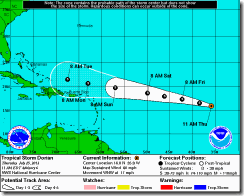
Until he gets closer there isn’t much to say. The 11AM NHC advisory on Dorian showed winds of 60mph, central Pressure of 999mb, with movement WNW at 17 mph. Dorian is forecasted to pass slightly to the north of the Lesser Antilles later in the weekend into the start of next week.
Here is a weather chart for Next Thursday. The cold front and low pressure (this is not just a surface low it has low pressure up into the mid levels, as well)... that will move through the Northeast Sunday through Monday, will be setting across the Southeast. The Jet Stream will also be curving south. This would all imply Dorian would be blocked from moving to far north.
The Models are trying to keep up. The GFS run earlier today had Dorian north of Cuba and southeast of Florida in a little over 7 days from now. But the latest run of the GFS has Dorian dissipating as it crosses into the Dominican Republic. The GFDL is showing Dorian curving north. Here is where the GFDL shows Dorian on Tuesday.
The Canadian was showing a Carolina hit in the earlier run, but now in response to the cold front to the north has the Dorian going through the Florida Straits and into the Gulf.
Three different models three different fates for Dorian. I'm throwing out the current run of the GFS it just doesn't make sense at this time. The NHC is showing Dorian as a 70 mph storm when the GFS has him dead. in the Caribbean.
The storm moved over the cooler waters last night and stayed intact. The Atlantic water temperature will be more favorable by the end of the weekend The overall environment will not change all that much.
Dorian will be dealing with some weak shear and moisture in the mid levels will stay fairly low. Dorian should stay on this west to northwest track as he skirts under the strong high in the Atlantic.
But as far as intensification I don't see a lot going into the weekend. After that I'm not sure. The SST closer and along the East Coast and in the GOM are quite favorable for development, if Dorian can get to them and take advantage of them.
The computer models all agree on Dorian's track over the next 4-5 days. Most of them place Dorian around the vicinity of Puerto Rico on Tuesday. After that, the models break rank some have it going into Florida, curving out to sea, or as I showed above going into the GOM.
Here is the NHC tracking cone. Most can see that if you're in Florida you have to keep an eye on this thing.
The computer models are always dealing with tons of real-time data. Therefore, they change in real-time. Like us they can only deal with the data on hand, sometimes this data is faulty. But like Chantal, Dorian is a survivor. He has found ways to deal with a bad environment and has been surprising everyone every since he was born. He looks like he wants to be a Hurricane. I personally think he will find a way. Two things are in his favor right now: one, is his small size and two, the fact that he is bottom heavy, that long leg to the south I keep talking about, is feeding him the tropical moisture he needs.
How long he can maintain hurricane strength is another question. Right now, the doorway to the north looks closed. But this can change. There is a lot more to forecasting hurricanes than models, maps, and charts. One has to take climatology into the mix as well.
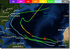
Brian McNoldy had this to say in the Capital Weather Blog " In the past 162 years, just three other storms were named (tropical storm intensity or greater) this far east during the entire month of July: Anna 1969, Alex 1998, and Bertha 2008. Dorian has joined that list, and for reference, its current location is marked with a red “D”… basically right on top of Bertha’s track; however, Dorian is not expected to curve out to sea so quickly."
Here is the graphic that McNoldy had in the Capital Weather Gang Blog.
Computer models also store tracks of past hurricane seasons. They use this data to try and get a better hand on what might happen. With only three storms to compare Dorian to since 1851 doesn’t give them much data to draw from. This is one of the reasons why they’re have some problems with Dorian, just as they did with Chantal.
The key to Dorian is intensification the stronger he can become the more he has to say about where he’s going and what his fate will be. After the Weekend, Dorian’s overall strength is in question.
But looking at Satellite you can see he is a Cape Verde storm ; one that will be coming up over the islands. Right now, the only foreseeable thing standing in his way of becoming a hurricane is this light to moderate shear. Over the next few days we will see how that battle goes.
But as I’ve said, a lot will depend on how strong Dorian at the time. There is still a lot of time for changes and believe me there will be at least a few if not more.....Each hurricane has a distant personality, in forecasting tropical weather one has to take that into account too.....Right now, he is a long way out in the Atlantic. So, for now all we can do is watch and wait.
Rebecca.


No comments:
Post a Comment
Thank you for taking the time to comment, I will answer as soon as I can.