Today’s
Northeast weather discussion…
How did my forecast work out for your area?
Hope you had
a wonderful Thanksgiving despite the messy storm that went through. That storm
has pulled away, and if you’re not downwind of Lake Erie and Lake Ontario, conditions
are seasonable cold, with temperatures running 10-15 degrees below average for
this time of year. But other than nuisance isolated snow showers and rain
showers, it’s not bad. But for those downwind of Lake Erie and Lake Ontario, it’s
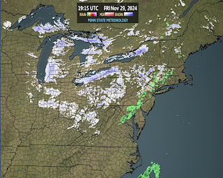
a completely different story. Radar
shows the lake bands off the lakes due to west-to-west southwest winds, moving
over the warmer water, is producing a heavy band off of Lake Erie and another
heavy band off of Lake Ontario. Snowfall rates of 2to 4 inches per hour will
produce upwards of 3-5 feet of snow under the most persistent bands for the Tug
Hill Plateau and the snowbelt south of Buffalo.
Lake Effect
Snow Warnings are in effect off of Lake Erie for Southern Erie, Wyoming,
Chautauqua, and Cattaraugus counties. Off of Lake Ontario Lake Effect Snow
Warnings are in effect for Jefferson, Lewis, Oswego, and St. Lawrence counties.
These warnings off of both lakes will last through Monday.
For Sunday
night and Monday, a trough will work through, this will cause a wind shift that
will move the snow bands south and east of the lakes, these areas will be
dealing with accumulating snows.
The region
will be dealing with breezy winds right through the weekend.
The first
half of next week should be mainly dry but cold. Then for Wednesday and
Thursday a clipper system will approach and move through bringing rain and snow
showers.
As I’ve been
saying, waves of cold are going to be an issue for at least the next 10-14
days. This is going to ensure below average temperatures. With the pattern
staying active and the setup favoring clipper systems, there will be additional
chances for snow as we move forward.
Drought
Conditions.
U.S. Drought
Monitor
Per the
Northeast Regional Climate Center…“The region received some needed
precipitation this week. West Virginia and southwest Pennsylvania saw enough
improvement in soil moisture and streamflows for one-category improvements,
eliminating extreme drought. Maryland also saw improvements this week.
Elsewhere, the precipitation was enough to pause conditions from deteriorating
but not enough to improve conditions. The U.S. Drought Monitor released on
November 27 showed 4% of the Northeast in extreme drought, 24% in severe
drought, 33% in moderate drought, and 36% as abnormally dry compared to 6%,
25%, 31%, and 35%, respectively, last week”.


We had snow all day yesterday but it didn't really accumulate. Just now we had a snow squall that dropped 2 inches quickly and it's still snowing. Dalton MA
ReplyDelete