
The Midwest Is getting ready to explode into a big severe weather day Including the possibility of long track dangerous tornadoes, The setup in the midwest is Is close to perfect and nearly textbook. The timing to our west will be this afternoon into tonight.
For our region, the severe weather risk is also increasing especially across southern Pennsylvania, Maryland, Delaware, New Jersey and points south.
Upper Level energy swinging out ahead of this along with the proximity to a strong low level jet; will mean we have to be on the lookout for supercell thunderstorms coming out of the Ohio Valley tonight into the overnight. As the storms tonight come out of the Ohio Valley they should be weakening but they will still be capable of producing damaging winds hail and possibly some isolated tornadoes.

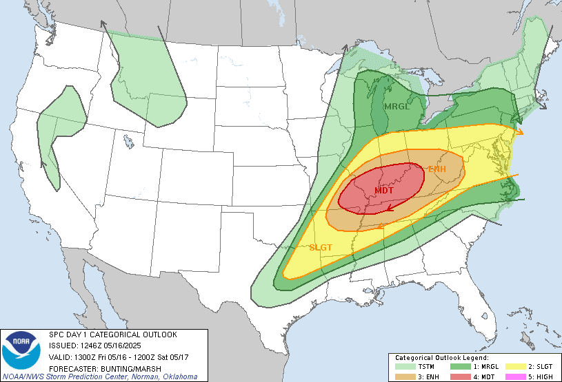
Tomorrow the severe threat expands east. Tomorrow we will have a couple of lines of storms moving across New York State And Pennsylvania Storms. Scattered severe cells will be capable of strong damaging winds, hail and isolated tornadoes. The setup overhead for tomorrow doesn't look as volatile as it is today over the Midwest. Right now it looks like the conditions tomorrow night should allow the storms to weaken As they head into New England. But isolated strong to severe storms are still possible across western new England. The storm protection center has a Slight Risk For severe weather extending from New York State down through far western Pennsylvania, Maryland, Delaware and New Jersey. With a Marginal Risk that extends across a large part of the rest of the region. It is quite possible that the SPC will expand the overall area of the slight risk and could possibly even upgrade it to an Enhanced Risk. The timing for the greatest chance of severe weather will be late morning into the evening.

The surface chart shows the upper level wall That's it heading into the Great Lakes along with that warm front that is moving into our region. Live this front New York state And Pennsylvania can expect a few rounds of rain showers and thunderstorms. The storms Storms and rain will be scattered so not everyone will see them and it won't be raining at your local location for the entire day. The storms will be capable of heavy downpours, hail and frequent lightning. I discussed the SPC outlook above. Our temperatures will be quite mild today as that warm front moves through. That warm front will continue lifting through the region late today into tonight. the threat for scattered showers and thunderstorms will continue into the night Again these storms will be capable of heavy winds Hail and even a few tornadoes cannot be ruled out.
Looking back at the surface chart That cold front Will be coming through the region tomorrow. As the cold front moves into the mild air mass We will see Widespread rain showers heavy at times and scattered thunderstorms, again I talk about this above.
The air coming in will be cool and a trough will be hanging around so we'll still run the risk for scattered showers. Winds will still be breezy.
On Monday high pressure will be building into the region. This will be hanging around through Tuesday Keeping us sunny mostly dry but still quite cold. This area of high pressure Will start to pull away Wednesday As another system approaches we will see increased clouds And rain starting west to east across the region later in the day. The area low pressure will be moving across the region And Thursday Rain showers and thunderstorms. With the front we can expect scattered rain showers and thunderstorms. Friday we'll see the low pressure start to leave the region but we can expect to see the scattered showers hang around.
Right now The Memorial Day weekend is looking a bit wet; As we look to be dealing with yet another upper level low impacting the region. But we have time to see how things evolve so we will see.
We're going to have another system come out of the Rockies early next week that is going to produce a lot more severe weather.
No comments:
Post a Comment
Thank you for taking the time to comment, I will answer as soon as I can.