
Welcome to the first truly hot day this year.
The high pressure is still in control but it is starting to slip to the east.


Today is gonna be dry but it will be hot and muggy. This will be due to the air flowing around the high pressure ridge and ahead of the approaching cold front allowing for a strong southwest flow into our region. Daytime temperatures Will run 10-20 °F above average. With the increased dew point it could add another feel like temperature of 10°F. So drink plenty of water if you're gonna be outside. We're also gonna be dealing with Canadian wildfire smoke. So the sky will be hazy, those with asthma and other breathing issues might want to limit their time outdoors. Most of the smoke will stay up in the atmosphere but there's a chance that some of this could come down to the surface Causing some air quality issues. Tonight is also gonna be warm due to all the humidity.

The cold front we can see on the surface chart in the midwest impacting our weather Will be impacting our weather Tomorrow and Friday. The front is going to be moving Very slowly. Tonight we will notice Some high clouds starting to encroach into parts of the region. The cold front will be approaching New York State Tomorrow with clouds increasing ahead of it.
Rain will likely work its way in towards Central New York late morning early afternoon. Isolated showers will be working into southwest Pennsylvania in the afternoon. The Mid Hudson valley will likely see showers moving in mid to later in the afternoon. The showers should be getting into Maine during the afternoon. Eastern Massachusetts could also see very isolated rain showers later in the afternoon. The front is going to be slowing down there may be a few very isolated rain showers and maybe a rogue thunderstorm for Southeast Pennsylvania, New Jersey, Maryland and Delaware during the late afternoon/evening. But most won't see anything.
Isolated thunderstorms will pop-up during the afternoon and evening tomorrow.

Some of these thunderstorms will be strong to severe. This will be especially true for the western Pennsylvania Upper cross New York State into Northern and Central New England. The storm prediction center (SPC) has these areas under a Marginal Risk for severe weather. The greatest danger will be strong damaging wind gust, some hail, localized heavy rain and frequent lightning ,due to the wildfire smoke.
The cold front will weakening and continue to slowly slide through during the overnight and on Friday.

Rain and thunderstorms will still be ongoing across most of New York State, northern New England into Pennsylvania, but the front boundary movement will be bringing scattered rain showers and isolated thunderstorms into southern New England And Maryland, Delaware and New Jersey. The cold front will continue to be slowly sliding out of the region on Saturday. We should see rain and thunderstorm chances lessening northwest to southeast as we move through the day. The cold front should finally be off the coast on Sunday. I can't completely rule out a few isolated showers but the vast majority of us should stay dry.
Behind the cold front temperatures will cool 10-15 °F allowing temperatures to fall back down to seasonal for this time of year. Due points are also going to be falling.

Image courtesy of Tropical Tidbits.
Monday A warm front will slide through our region. We also look to see yet another cut off upper level low to develop in the northern Plains into the northern Great Lakes. A cold front is going to pass through for late Monday into Tuesday, bringing rain showers And isolated thunderstorms. With the trough overhead the first half of next week looks to feature average to slightly below average temperatures. Then during the second half we should see warmer temperatures take over.
The tropics:
The area I mentioned a couple days ago, is now being monitored by the National Hurricane Center. Yesterday the NHC had the odds of development at a low 10%, for this to develop into a depression. If you look at the infrared satellite image you can see The swirling and lifting near Florida and the Southeast coast. This is a cold core system And not a warm core tropical system right now. Today they have lowered the odds to 0-10%.
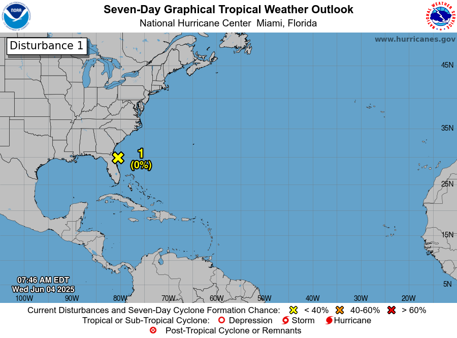
But as I said the other day I doubt this is going to develop into anything tropical or even subtropical. But we will see. This is going to move north and east as the approaching cold front forces it to head out to sea. So regardless of what it does it won't be an issue for the Northeast and northern Middle Atlantic.
No comments:
Post a Comment
Thank you for taking the time to comment, I will answer as soon as I can.