Meteorological
spring is right around the corner with the season kicking off on the first day
of March; but Astronomical spring (vernal equinox) is less than a month away,
which officially begins on March 19 at 11:06 p.m.
So here are
my overall thoughts on the 2024 Spring Season in the Northeast.
But first,
let’s take a look at the 2023-2024 winter season since it is nearing its end.
Based on
pressure anomalies, the overall pattern was quite similar to what the winter
outlook indicated. The winter also favored above average precipitation. But
what caused Winter 2023-2024 to be basically a no-show were the warm temperatures.
With winter officially coming to an end, there is no doubt that the winter
2023-2024 will go down as a very warm winter. In fact, it is one of the warmest
winters in recorded history. This warmth has also led to record-low Great Lakes
ice cover for this time of year. If winter were to end today, this would go
down as the warmest winter on record for the vast majority of the Northeast and
northern Middle Atlantic. The warmth is in spite of the disruptions in the
polar vortex we saw during the winter. In the outlook I said we would see disruptions
in the vortex, this did indeed work out. In fact, the PV has seen so many disruptions it caused issues
and allowed the PV to interfere with itself. During the winter, we had the problem that many times the cold air was directed away from the Northeast.
In spite of
all the warmth, there were cold outbreaks. We had cold air moving into the
region in November into the first week of December. Then we warmed up for Mid-December.
Before a cool off for closer to the end of the Month. January started very warm. Then once we got
into Mid-January, the Polar Vortex was displaced, brought about by the Sudden
Stratospheric Warming Event in Early January.
So, when we
got to Mid-January the Canadian gates opened, and true arctic air invaded the
East Coast. The cold brought by the Sudden Stratospheric Warming Event in Early
January with the displaced Polar Vortex help
set off some moderate winter storms for the Middle Atlantic and a few bigger
storms for the general Northeast. There was the Pre-Thanksgiving storm A winter
storm affected Northern New England shortly before U.S. Thanksgiving., Three
storms in January, then we had the Pre-Valentine's Day nor'easter on the 10–13
of February. Then there was the February 15–18 nor’easter. There were also a
couple of major lake effect snow events that brought significant snowfall down
wind of Lake Eire and Lake Ontario. But
the overall above average temperatures, resulted in huge snowfall deficits for
many parts of the Northeast.
So, while
the Outlook did get the general pressure pattern and the above average
precipitation right; It fell short when it came to overall snowfall accumulations
over a large part of the region.
If you want to look at my 2023-2024 winter
outlook, you can find part one here. The other two parts you can find by
following the links in part one.
The major
players for the demise of snow in the Northeast…
One of the
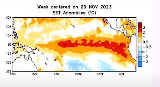
main drivers during this past winter was El Nino. In November the El Nino became strong with water
temperature in the Nino region 3.4 reaching 1.9°C. Strong El Ninos has no
strong correlation to snowfall here in the Northeast and Northern Middle
Atlantic, there have been seasons that saw little snow fall and seasons that
had a lot of snowfall. These mixed signals make it hard to pin down seasonal snowfall
amounts.
There's also
has been a lack of persistent high latitude blocking. The lack of a Greenland
block kept the pattern fast and zonal (west to east). The result of no blocking
meant the cold air from Canada couldn’t hang on for longer than a few days.
Instead, blocking high pressure setup over much central and eastern Canada,
keeping the Northeast persistently much warmer than average overall.
The Tonga’s
Hunga Tonga-Hunga Ha apai volcanic eruption in 2022 vaporized a huge volume of
water, that released an enormous amount of water vapor into the atmosphere. This
water vapor didn’t reach the northern hemisphere until the end of 2022 into
2023. So, it’s reasonable to think that the recent warming in the Northern
Hemisphere is at least in part due to the Tonga Eruption. That eruption is going to heat us up for
several more years, add in El Nino’s effect and we ended up with a major winter
interruption.
The
subtropical jet was active all winter it was also very strong. For that reason,
those times that we did get cold enough for snow, the northern jet didn’t see
much in the way of moisture interaction from disturbances in the Subtropical
Jet. Because there was a lack of high latitude blocking and the southern jet
was so strong, the streams phased too late to bring major snowstorms to the
Middle Atlantic and Northeast.
Why discuss winter when doing a spring outlook? Because, Spring is a transition between winter and summer. Spring can be greatly influenced by the winter that went before it.
If you don’t
want to read the meteorological analysis, you can skip to the bottom.
OK what
about Spring for 2024…
El
Nino-Southern Oscillation (ENSO)…
Earlier in
Spring 2023, I discussed how Sea Surface Temperatures (SST) were quickly
heating up in the eastern Pacific Ocean. By June of 2023, NOAA declared that El
Nino was well underway, the first one in four years! SST were roughly 0.5°C
warmer than average in this region of the Pacific. The El Nino did become very
strong, during the winter.
Here is a look at the SST anomalies from November 29th.
Here is a look at the SST anomalies for February the 21st.
Currently in Nino region 3.4 the El Nino is considered weak to moderate. However, while the El Nino is dissipating, the atmospheric conditions brought on by the El Nino, are going to linger, which means the warmer and wetter conditions experienced across the region during the winter should continue into the spring months.
The image
below shows the ENSO regions across the tropical Pacific. The main region is
seen in the image as the Nino 3.4 region. This area covers parts of the eastern
and western tropical Pacific and is where the ENSO phase is determined.
We just
can’t look at the surface, looking at the subsurface water temperature anomalies
December
19th
February 17th
We can see a
large area of cold water is moving towards the surface.
The subsurface temperature changes have prompted the Climate Prediction Center to issue an official La Nina watch.
IRI ENSO
Predictions Plume
With El Nino
looking to quickly weaken through the upcoming spring, neutral conditions will
end up taking over by the end of Spring, with the possibility of a La Nina
developing before or during the summer into fall of 2024.
We also have that positive (warm) North Pacific Oscillation. This along with the warm Gulf of Mexico, could make for an active severe season in Dixie Alley and Tornado Alley in the Plains.
This will of
course have ramifications on the 2024 Atlantic tropical season: I will discuss
the Atlantic hurricane season in a separate blog post.
Madden
Julian Oscillation (MJO)…
Currently the MJO is very weak and is inside the null circle, meaning it’s not exerting any forcing on the pattern. Looking at the MJO forecast from the GFS and Euro, we can see the MJO looks to stay weak, not putting any influence on the pattern at least through the middle of March.
GFS
Euro.
The Polar
Vortex…
We currently
have warming in the Stratosphere. The Quasi-Biennial Oscillation (QBO) has been
in (and still is) in the Easterly phase. This is the reason we had so many stratospheric
warming events this winter. So, the current warming is no surprise.
During
March, the QBO is going to weaken, and most likely will become westerly at some
point, with the QBO becoming weaker, the tendency for PV disruptions is going
to fade away.
The current
stratospheric warming is going to disrupted the PV, which will allow colder air
to move into the Mid Latitudes. Like we saw during mid-January. But the problem
is the cold air is looking to be deflected into Asia and Europe.
This means
that we’re going to see the Pacific Jet become strong and very zonal. This will
mean it will run roughshod over the Pattern over North America.
The same
general pattern we saw during the winter, should stay with us as we go into
Spring.
March…
March is
always a transition month. So, we’re
typically on a rollercoaster. This year will be no exception. March will likely
start out quite mild. Then we should see a flip to cooler temperatures. As
has been the case during the winter, this cooler shot won't have a lot of staying power; but it could hang around for at least part of the 2nd half of March. March is likely to experience these fleeting shots of
cool/cold air, but they will likely quickly be replaced with warmer
temperatures. March should be quite active. Precipitation should average above average for the month. We
haven’t had a lot of snow this winter. but I don’t think the Northeast into
Middle Atlantic is completely out of the woods when it comes to snow, as I
can’t entirely rule out the snow chances; perhaps even a bigger storm for part of the region. With that said, the pattern won’t be
super supportive for snow storms.
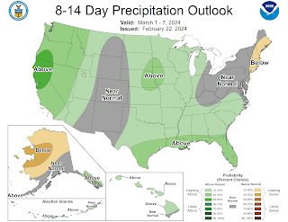
The NOAA
temperature and Precipitation outlooks here take us to March 7th…
April…
For northern Pennsylvania and points north, temperatures could start out a bit cool, but overall temperatures should end up average to slightly above average for mid month. Then there is a chance for colder air to invade as we go through the second half of April. But southern Pennsylvania and Middle
Atlantic will likely end up overall well above average for the entire month.
Precipitation should be generally above average across the Northeast into northern Middle Atlantic. the wet pattern will continue from March. Showers and storms will keep us watching the local river levels
Severe season could start early this year.
May…
Overall temperatures
should average well above average across Northern parts of the Northeast. With
temperatures above average across the southern Northeast into the Middle
Atlantic. But we're likely still going to be on a Roller Coaster. There could be a few bouts of very warm temperatures during the second half of May.
Precipitation is going to be dependent on storms and where they form and track. But it looks like the pattern very well could support rain and storms. I think May will feature quite a bit of severe weather in the Northeast. I do think there will be an elevated tornado risk in May, across Southern New England, the New York State Southern Tier, into much Pennsylvania.
Temperature outlook for March, April, and May.
Precipitation outlook for March, April, and May.


No comments:
Post a Comment
Thank you for taking the time to comment, I will answer as soon as I can.