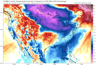
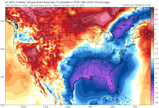
Today’s Northeast weather discussion…
Looking at today, away from the Great Lakes there are a few scattered snow showers over New England, with everyone else generally dry. Downwind of Lake Erie and Lake Ontario heavy lake effect is falling. The lake effect will continue off of Lake Erie tomorrow, with the lake effect continuing off of Lake Ontario into Saturday morning. When all is said and done, under the most persistent bands, upwards of 3 feet will have fallen off of Erie, and around 4 feet off of Lake Ontario.
The first
part of December has been overall cold.
Over the
next few days, we’re going to see several cold fronts with troughs come through the region,
these will keep it unsettled and bring scattered snow showers and flurries to parts of northern parts
of the region, while southern parts of the region deal with lower elevation
rain/mix showers and snow showers in the higher elevations of Pennsylvania.
Next week is
going to feature a warming trend, with scattered rain showers for many of us
and higher elevation snow showers.
Right now,
we’re in a transition to cold closer to Christmas and
especially into January.
Thursday and Friday a frontal system will be approaching and moving through. This will be the begin a transition to cold closer to Christmas and especially into January.
With the
pattern staying very active, there will be more snow chances moving forward.
With the cold in place for Christmas week, could we see snow around or even on
Christmas, maybe!


🤞🤞 for snow for Christmas
ReplyDeleteI hope not: people are traveling around going to family and friends for the holidays,,
ReplyDelete