


We have a very strong area of low pressure over the Canadian Maritimes, along with an approaching arctic front. The combination of these two is creating a tight pressure gradient, resulting in these strong winds. Temperatures are also very cold. The strong winds will stick around into the evening, then slowly subside a little. These west-northwest winds gusting to 50 to near 70 mph. This is creating wind advisories and warnings across the region. The high winds are causing drifting, low visibility and whiteouts. In addition to the strong winds, we have a narrow but intense lake effect band between Syracuse and the Southern Tug Hill. The band will wobble a bit, but generally stay put, snowfall amounts of 8-16+ inches will fall under the most persistent part of the band today, with 4-8 inches along the edges.
Tomorrow will still be breezy with gust of 30-45 mph (but winds could be a bit stronger over Maine) it will continue to be very cold. The lake effect (with additional accumulations) will be ongoing as it pushes north before it starts to weaken tomorrow night. Wednesday is looking to see much more Sun but cold temperatures will remain.
The next storm
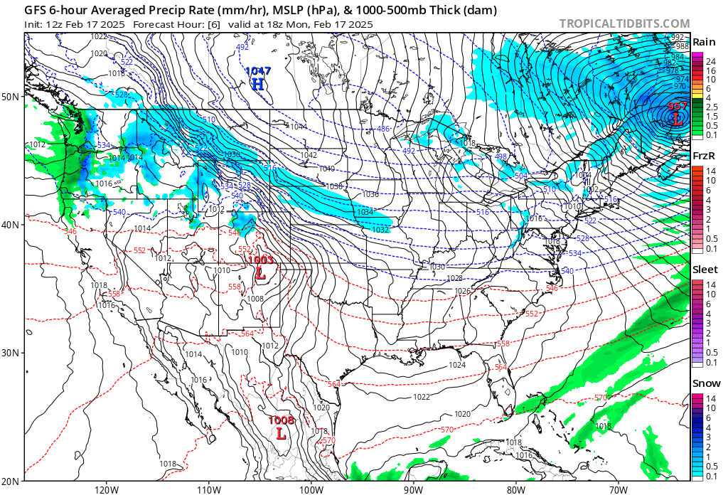
We have a disturbance in the northern stream and another over the Plains. Tuesday night into Wednesday we’re going to see low pressure develop along the Gulf Coast; from here it will track toward Carolinas for Thursday morning, staying offshore. The northern upper-level low looks to stay just behind the southern disturbance. The lack of phasing between the two pieces of energy means this is likely to stay on a north and east track, instead of coming up the Coast. This track will keep the bulk of the snow south of the I-95 Corridor into Virginia and North Carolina. Even though significant snow is looking unlikely, The Southern 1-95 Corridor for DC and Baltimore could see a few inches of snow. It is possible some of this snow could make it into Southeast Massachusetts, especially the Cape and offshore Islands.
That’s been the theme for storms this year. Staying to the south of southern New England. Seems like we may not get a big snow storm at this season.
ReplyDeleteEach storm is a product of it's current setup and dynamics. So it is still possible for a big storm to impact southern New England. Many other parts of the region is having a very snowy winter so far. With the volatile pattern anything is possible.
DeleteThank you.
ReplyDeleteYou're welcome
DeleteYet another lost coastal storm opportunity. Do you think March may see that change? The March 13 time frame has been a magnet for big storms coming up the coast through the years.
ReplyDeleteIt is possible we will see a major storm moving forward, the timing of the phase with this one was just off by a bit.
DeleteDid the Southern Surface Low stay to far to the South pushing the storm out below us.I know my sons GF was supposed to leave Sunday morning to go to North Carolina,she waited until late this morning.Before she left she called her sister who told her she would be stuck there due to an impending Large Snowstorm due to drop over a foot and they have one plow and pick-ups.I looked at him and said that was our storm,it’s going out to the South.I was bummed another storm and it would look like a normal winter.Any chance that the Northern will phase with the Southern low or has that ship sailed.
ReplyDeleteWe did get nailed yesterday and then it went back to heavy snow late in the day into the late evening and then off and on all night until 9 am.Finally a storm that left its mark.However nothing but rain and 40's for next week then March and Sun getting higher in the sky.Well at least we had a cold winter with some small storms that kept the ground white.
The timing was off just enough, that the northern and southern disturbances phase too late, to allow the storm to become strong and come-up the Coast. We could still see a strong nor'easter. But storm has it's own dynamics. So we will see!
DeleteThe South is going to get up to 12”,I don’t know how much bigger the storm would have been if the North and South would have phased.I know we have been colder than in the past 8 winters so the 3-4” storms didn’t turn to rain and wash the snow down the drain.We missed getting the big numbers on 2 storms but did get 5” and 6” from two storms that could have dropped a foot or more each time.So a Great job was done by our Weather Gal.We knew when a storm was coming and when it would get very cold and or very Windy,Plus we knew how many feet of snow the Tug hill received.Thank You so much.
DeleteThank you.
ReplyDeleteYou're welcome, Karen.
Delete