Friday, March 31, 2023

The March 24th to March 27th, 2023 tornado outbreak.


The event was well telegraphed. The Storm Prediction Center (SPC) started talking about the potential for organized severe weather across the Southern Plains on March 18th. When the system came ashore in California it brought heavy winds and flooding rainfall. As the system moved from the West Coast, the SPC kept discussing the potential and issuing additional risk areas where highlighted. By March 23, the SPC issued a Slight Risk for severe weather from Texas northeastward into Missouri, primarily for the threat of large hail. Scattered reports of large hail and damaging wind gusts were received from Texas across into the Mid-Atlantic states. As things progressed two EF1 tornadoes occurred in Parker County, Texas, during the morning hours of March 24.

As the day went on, a deadly severe weather and tornado outbreak began affecting portions of the lower Mississippi River Valley in the United States.

The atmospheric setup:

A deepening trough was quickly moving eastward. We had a strong area of high pressure sitting over the Southeast CONUS.  Out ahead of the deepening low pressure a warm front was dragging a warm moist airmass air mass from the Gulf of Mexico.  A strong jet stream aloft and strong mid-level winds created an unstable air mass over Louisiana, Arkansas, Tennessee and Mississippi; where surface temperatures were into the 80's °F with dewpoints in the upper 60's into the70's.  This set the stage for widespread heavy rainfall and severe thunderstorms.


Earlier in the day, there was dry air near the ground, with a warmer layer around 15,000 feet creating a weak to moderate atmospheric cap. This hindered strong supercells and tornadoes from developing. However, over the next few hours, the environment chanced very quickly across the Mississippi Valley. The winds ahead of the front were out of the South bringing in all that warm air closer to the surface, at the same time the jet was dropping in from the west, providing a west wind aloft. Ahead of the advancing trough, out in the warm sector, a few squall lines began developing farther south, particularly along north to south oriented prefrontal confluence bands.  These bands have to do with the prefrontal tough ahead of the cold front where wind flows inward parallel to the general flow and leads to a wind shift. The shifting winds allowed the storms to start spinning. A tornado watch was issued shortly thereafter at 5:15 p.m. CDT for portions of eastern Arkansas, northeastern Louisiana, central and northern Mississippi, and western Tennessee.


At 1:00 PM

When temperature gets warmer and the dew point get drier you get a mix layer cap. The Cap is weak, but just enough to slow down thunderstorm development.

Looking at the severe indices. To save me a lot of typing you can refer to the severe weather forecasting tip sheets to see what the sounding is showing.

3cap is 40 Jkg

Mixed layer cape 568

Holograph shows a very unorganized wind field.

SFC 1km is 61

SFC 3 km is 141

6km Shear is 40

BRN is 56

STP both of them are 0.2, A majority of significant tornadoes (F2 or greater damage) have been associated with STP values greater than 1, while most non-tornadic supercells have been associated with vales less than 1 in a large sample of RAP analysis proximity soundings.

Supercell parameters are 3

The entire sounding shows the atmosphere is unsupportive for Supercells and tornadoes. 


At 7:00 pm

The Cap is still there but it is breaking down.

Looking at the severe indices. To save me a lot of typing you can refer to the severe weather forecasting tip sheets to see what the sounding is showing.

3cap is 18 Jkg

Mixed layer cape 995

Holograph shows more in the way of an organized wind field, with much better inflow.

SFC 1km is 172

SFC 3 km is 345

6km Shear is 58

BRN is 118

STP is 2.1 and 1.4, A majority of significant tornadoes (F2 or greater damage) have been associated with STP values greater than 1, while most non-tornadic supercells have been associated with vales less than 1 in a large sample of RAP analysis proximity soundings.

Supercell parameters are 8.8

The entire sounding shows the atmosphere is supportive for Supercells and a chance for short track tornadoes.


At 10:00 pm

The Cap is gone, allowing thunderstorms to explode.

Looking at the severe indices. To save me a lot of typing you can refer to the severe weather forecasting tip sheets to see what the sounding is showing.

3cap is 91 Jkg

Mixed layer cape 1642

Holograph shows the wind field increasing quickly, with a lot of inflow and a lot of spin with height.

SFC 1km is 319

SFC 3 km is 384

6km Shear is 56

BRN is 115

STP is 3.8 and 3.1, A majority of significant tornadoes (F2 or greater damage) have been associated with STP values greater than 1, while most nontornadic supercells have been associated with vales less than 1 in a large sample of RAP analysis proximity soundings.

Supercell parameters are 12.9

The entire sounding shows the atmosphere is very supportive for Supercells and strong to violent long track tornadoes.

This increased forcing that allowed the squall lines to strengthen with discrete supercells forming out ahead of the squall line. Discrete Supercells form on their own ahead of a squall line.  Because of this they don’t have to compete with other storms or the squall line for energy. This makes these kinds of supercells very dangerous as they are capable of becoming very strong and have much better odds of producing strong violent tornadoes.  As we got into the evening a strengthening nighttime low-level jet and rising levels of surface moisture led to the development of a substantial supercell across western Mississippi. As the supercell approached the Mississippi River, a tornado started to develop. The NWS issued its first tornado warning around 20 minutes before the storm reached Rolling Fork. Then before 8 p.m., the supercell produced a tornado, the tornado started as a small cone, this intensified rapidly and soon became violent. The National Weather Service issued a rare tornado emergency warning for Rolling Fork and Anguilla, Mississippi. As the significant tornado was heading straight for them. Then at around 8:05 p.m. the tornado struck Rolling Fork, the tornado continued to stay strong to violent as it moved through Midnight and Silver City all in Mississippi.

The Tornadoes:

The Enhanced Fujita Scale (EF Scale) classifies tornadoes based on the amount and type of damage caused by the tornado. It is broken down into the following categories: EF0...Weak.....65 to 85 mph, EF1...Weak.....86 to 110 mph, EF2...Strong....111 to 135 mph, EF3...Strong....136 to 165 mph, EF4...Violent...166 to 200 mph, EF5...Violent...>200 mph

The Fujita Scale (F-scale) was replaced by the EF Scale in February 2007. The F Scale is broken down into the following categories: F0 – Light Damage (40 – 72 mph), F1 – Moderate Damage (73 – 112 mph), F2 – Significant damage (113 – 157 mph), F3 – Severe Damage (158 – 206 mph), F4 – Devastating Damage (207 – 260 mph), F5 – Incredible Damage (261 – 318 mph).

The National Weather Service in Jackson, Mississippi surveyed the damage and said, the Rolling Fork, Midnight and Silver City tornado was an EF4 with peak winds of 170 mph, a path width of ¾ of a mile, with a track length of 59.4 miles.  This EF4 caused incredible damage. The same super cell produced two subsequent long track tornadoes.


Just four minutes after the Rolling Fork, Midnight and Silver City  EF4 dissipated, a new tornado developed. This tornado struck Black Hawk and Winona in Mississippi, where is caused significant damage. This tornado was rated an EF3 with peek winds of 155 mph, the damage path was 0.7 of a mile wide at points, the track length was 29.2 miles.

The third long-track tornado, was also rated EF3 by the National Weather Service Memphis, with top winds of 155 mph, a very wide damage path up to 0.9 of a mile, with a track length of 36.91 miles. This EF3 caused significant damage across Amory, Alabamia.

The NWS issued multiple tornado emergency warnings for all three tornadoes during their lifetime.

As of this writing There have been 14 confirmed tornadoes for the 24th event.

The outbreak continued March 25 into the 27th. There were 7 confirmed tornadoes on the 25th, across Alabamia, Tennessee, and Georgia, including two EF2 that struck Alabama. March 26 saw 6 confirmed tornadoes over Alabamia and Georgia. Alabamia and Georgia saw three tornadoes on the 27th.


Saturday, March 18, 2023

The 2023 Hurricane Season Outlook Part One


The tropical season will be here soon. As I try to do every year, I release a multipart Hurricane Outlook. This will be part one.  This first part will be just a cursory look at some of the features that look to have an influence on the hurricane season. Later parts of the series will narrow down and expand on curtain aspects such as teleconnections, sea Surface temperatures, vertical wind shear, Saharan dust, and other factors.   

I will start with a few basic definitions. I will use these during the hurricane season.

Storm surge is a very pronounced rise in sea level as sea water is pushed inland. Storm Surge can travel many miles inland. Storm Surge accounts for the majority of injuries and deaths associated with tropical cyclones.

The Saffir Simpson wind speed scale is a one to five rating system based on a hurricanes maximum sustained wind speed. The scale is only based on wind speed. This is a major problem as it doesn’t show the true danger the storm processes such as storm surge and rainfall flooding and the chance for tornadoes.

The Saharan Air Layer is a massive plume of very dry dusty air that originates from the Sahara Desert. These plumes can make it across the Atlantic Ocean and into the Caribbean, Gulf of Mexico and over the CONUS (Continental United States).

The tropics are a region of the Earth that surround the equator, they are between the latitude lines called the Tropic of Cancer in the Northern Hemisphere and the Tropic of Capricorn in the Southern Hemisphere. The climate of the tropics consists of a yearly mean temperature of 64 degrees Fahrenheit (18 Celsius) and have very high humidity.     

A tropical wave (TW) (African Easterly Waves) is an area (cluster) of low pressure that generally moves east to west across the tropical Atlantic, due to the prevailing easterly trade winds. They're typically situated north to south and are generally slow moving. These waves form within the African Easterly Jet Stream. Because the air flows faster within the Jet; these waves can begin to spin, increasing the risk for tropical cyclone development.  The meteorological reason for a tropical wave has to do with the distribution of warm moist air toward the poles, and not the formation of tropical storms.  

A tropical cyclone (TC) is a generic term for a rotating organized area of convection (thunderstorms) This area of low pressure typically forms over water with at least a temperature of 79 to 80 degrees Fahrenheit (26.5 Celsius). To be determined to be a TC it must have a closed low-level circulation not attached to any front. TC’s rotate counter clockwise in the Northern Hemisphere.  A TC has a warm core, meaning the air in and around their center is warmer than their surroundings.

A tropical depression (TD) is a TC that has sustained winds of 38 mph (33 knots) or less.

A tropical storm (TS) is a TC that has sustained winds of 39 mph to 73 mph. Once the TC reaches 39 mph it is given a name.

A hurricane is a TC that has sustained winds of 74 mph or higher.  Using the Saffir Simpson scale, Category 1 hurricanes have sustained winds of 74 to 95 mph (64 to 82 kt); a category 2 has sustained winds of 96 to 110 mph (83 to 95 kt) Once a hurricane’s sustained wind speed reaches 111 mph it becomes classified as a major hurricane. Category 3 is 111 to 129 mph (96 to 112 kt), Category is 4 130 to 156 mph (113 to 136 kt), and a Category 5 has sustained winds of 157 mph (137 kt) or greater.

Feeder bands are lines of thunderstorms that pull moisture into the center of a tropical cyclone. These lines can extend several hundred miles from the center of the storm.

Spiral bands are feeder bands that spiral inward toward the center of the tropical cyclone.

The eye is the center of the tropical cyclone

The eyewall is where powerful thunderstorms and violent winds sit just outside of the eye

The Main Development Region (MDR) sits between 10°N -20°N and extends from approximately just offshore from the west coast of Africa and westward towards the western-most sections of the Caribbean Sea. It’s called the MDR because most of the tropical waves in the Atlantic pass through it, leading to around 85% of the major hurricanes and 60% of all named storms form in the region.

The Cone of Uncertainty, is a cone shaped area added to a tropical cyclone tracking maps. It is designed to track the center of the tropical storm or hurricane.  As the cone widens into the future, the forecast accuracy becomes less and less.

Landfall, is where the eye hits and crosses the coastline.

Accumulated Cyclone Energy (ACE) is used to express the combined lifespan and strength of tropical cyclones. The seasonal ACE is sum of duration of all the individual tropical cyclones strength and duration. The higher the ACE the greater the destructive potential.

Rapid intensification (RI) occurs when a tropical cyclone's maximum sustained winds increase by at least 35 mph (30 kt) in a 24-hour period. RI is often coupled with a rapid decrease in a tropical cyclone's minimum pressure, and thus RI is also known as rapid deepening. However, the National Hurricane Center maintains its own definition of rapid deepening, which would be a drop of 1.75 mbar/hour or 42 mbars in a day.

Vertical Wind Shear Strong winds aloft that can prevent tropical cyclones from forming or intensifying. But sometimes TCs find a way to survive to become hurricanes in spite of strong shear aloft. 


The 2023 season…

Atlantic Hurricane season begins June 1 and lasts through Nov. 30.

The Atlantic storm names for the 2023 season are, Arlene, Bret, Cindy, Don, Emily, Franklin, Gert, Harold, Idalia, Jose, Katia, Lee, Margot, Nigel, Ophelia, Philippe, Rina, Sean, Tammy, Vince, and Whitney.


Early thoughts on analogue years…

Some of the past seasons I’m looking at are 1957 and 1976 Those hurricane seasons, came off a triple dip La Nina.  Two other years I’m looking at are 1997 and 2013 those are the years that saw the MJO become very strong in phase 8 during March.

.


 El Nino–Southern Oscillation (ENSO)…

El Nino and La Nina are opposing phases of the ENSO.

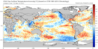
As many of y’all know La Nina means Sea Surface Temperatures (SST) in the Eastern equatorial Pacific are below average. Looking at the current SST anomalies. In the Pacific we can see warmer than average across the Eastern Pacific equatorial region and cooler than average temperatures in the Central equatorial Pacific.  This means we beginning the transition to El Nino. El Nino is when means SST temperatures in the Eastern equatorial Pacific are above average.

We are now in the ENSO- neutral phase.  Looking at the latest weekly NINO3.4 value to 12 March 2023 was +0.03 °C, which is within the neutral range (between −0.8 °C and +0.8 °C). This ends the 3 years of La Nina we’ve seen. While we look to stay neutral through the spring and into the first part of summer, a switch to El Nino should happen from late summer into fall.

That could mean a less active Atlantic hurricane season, a more active season in the Pacific

El Nino typically brings a strong Pacific subtropical Jet that is active. This many times brings hostile wind patterns across parts of the Caribbean and Atlantic Ocean.

El Nino is the warm phase of ENSO, in which the waters of the eastern Pacific are warmer than normal. Less vertical wind shear in the hurricane development zone west of Mexico typically brings more frequent hurricanes to the eastern Pacific basin. However, in the Atlantic, El Nino typically leads to fewer hurricanes. This is largely due to an increase in vertical wind shear along with a drier more stable atmosphere over the main development Region in the Atlantic. The wind shear makes it much harder for tropical cyclones to form, the stable air drastically reduces the lift required for tropical cyclones to form. The extra wind shear and more stable air, also tend to tamp down intensity of those tropical cyclones that are able to form.


The Madden -Julian Oscillation (MJO)…

Is a key climate driver that influences weather on a global scale. The MJO does have an impact on tropical cyclone activity in the Atlantic Basin. When the MJO is in phase 8,1 and 2 tropical activity in the Western Atlantic, Caribbean, and Gulf of Mexico increases.


Atlantic Basin SST…

 The SSTs in the Gulf of Mexico, Caribbean, and along the U.S. East Coast are well above average for this point of the year.  Besides SST another thing that is important is Ocean Heat Content (OHC). OHC is the temperature of the water under the surface down to a few hundred feet.  Looking at the OHC image, we can see OHC is very high in the Caribbean, into the Gulf of Mexico and off the Southeast Coast.  


My early thoughts on this year…

Based on the 30-year period from 1991 to 2020, an average season in the Atlantic Basin consist of 14 named storms, seven of these become hurricanes, with three of those becoming major (Category 3 or higher). As for ACE based on the 1951 to 2000 average it is 92.5. Based on the 1991-2020 average it is 122.7.  So, I will define the seasonal average for 2023 as between 92.5 and 122.7.

Looking at the numbers for those analogue years.

1957 was a below average season.  There were six named storms, as well as two tropical storms that went unnamed. The season had three hurricanes and two major hurricanes.  The season’s ACE was slightly below average at 84.

1976 was a below average season.  There were ten named storms, The season had six hurricanes and two major hurricanes.  The season’s ACE was slightly below average at 84

1997 was a below average season.  There were seven named storms, as well as an unnamed subtropical storm that formed in June. The season had two hurricanes and one major category 3 hurricane.  The season’s ACE was a modest 41.  

The 2013 Atlantic hurricane season was a slightly above average season with 15 named storms. But the season was well below average when it came to hurricanes. The season had two category 1 hurricanes and zero major hurricanes.  The season’s ACE rating was only an infinitesimal 36.   


Based on what I see so far…


El Nino doesn’t ensure a quiet season and it doesn’t mean there won’t be major hurricanes, but it does make it less likely.

Based on where the highest heat content is. Rapidly intensifying hurricanes will be a concern in the Caribbean and Gulf of Mexico.

Looking at the hurricane track pattern from the analogue years and the 2022 hurricane season, as well as return dates. The areas that look to have the greatest chance of landfalling TC are, the Florida Panhandle and the West Coast of Florida, the East Coast of Florida south of Jacksonville. For later in the season the Carolinas and near Bermuda.  The areas that look to have a lesser moderate chance of landfalling systems are the Mid Atlantic between Norfolk and New York City along with South Texas from around Port Isabel to up around Port Aransas. The other areas of the coast have a lower risk, but that doesn’t mean zero.


I expect we will see the first named storm in May.

This season looks to be an average to slightly below average season. Right now, I think 10 to 14 named storms 4-7 hurricanes and 1 -2 major hurricanes.  The Seasonal ACE looks to be 60-90.


Well, that’s it for part one. Part two will be released sometime in April, with part three being released end of April or first of June. These later parts will adjust what I said in part one.  If you have any questions, I will be happy to answer them in the comments here in the blog, or on my Facebook weather pages.


To read part two click here.