Tuesday, April 2, 2024

The 2024 Atlantic Hurricane Outlook part two


Here is part two of the 2024 Atlantic hurricane outlook. This is an extension of my analysis from my 2024 Hurricane Outlook Part One. I will take you through the reasons I think this is going to be a very busy season.

Link to part one.

The 2024 hurricane season is getting closer. The Hurricane Season starts on June 1’s and will end on November 30th.  The 2024 Hurricane season should be quite different as we transition from El Nino into A la-Nina.

 Sea Surface Temperature Anomalies (SST)…


In the Pacific

We still have slightly above average SST in the equatorial Pacific. But these are much cooler than they were a few months ago. We also have very warm SST in the Northwestern Pacific.

Both of these will play a big role in this year’s hurricane season.

In the Atlantic SST anomalies across the Main Development Region (MDR) (the area between the Lesser Antilles and the West Coast of Africa) are well above average. The SST in the Caribbean and Gulf of Mexico (GOM) aren’t quite as warm, but they are still above average. As we approach the heart of the hurricane season, these Atlantic Basin SST will become even warmer.

Average water temperatures since January in the Atlantic’s Main Development Region are 2 °F above last year, crushing previous highs by almost 0.6 °F.

Another thing we see in the Atlantic is cooler SST in the North Atlantic north of the MDR. This is another indicator of an active season. As this temperature contrast helps supply lift that the tropical waves can use to make it easier for convection to develop in the MDR that could lead to Tropical Cyclone development.

 The El Nino-Southern Oscillation (ENSO)…

The ENSO is a climate pattern that involves changing water temperatures in the Central and Eastern equatorial Pacific. There are three statuses of the ENSO: La Nina, neutral and El Nino.

Last year we were in a strong El Nino with SST anomalies peaked in November-December last year.

The primary metric used by NOAA to gage the strength of an ENSO event is the three-month-average temperature of the central tropical Pacific Ocean, specifically in the Nino-3.4 region.

The temperature anomaly—the difference from the long-term average, where long-term is currently 1991–2020—in this region is called the Oceanic Nino Index (ONI). We use a three-month average because ENSO is a seasonal phenomenon, meaning it persists for at least several months.

The threshold is further broken down into Weak (with a 0.5 to 0.9 SST anomaly), Moderate (1.0 to 1.4), Strong (1.5 to 1.9) and Very Strong (≥ 2.0) events.

While we don’t have official strength definitions, but, unofficially, an ONI anomaly of 1.5 °C or warmer is considered a strong El Nino. Last year the ONI peaked at 2.0 °C which would indicate a very strong El Nino.


Since November-December last year, SST have dropped. Some areas in the equatorial Pacific are already showing up cooler, as upwelling is bringing cooler water to the surface. We’re quickly heading toward neutral. We’re most likely going to become neutral sometime next month or in May. After that we should quickly move into La Nina. The chances are growing for a La Nina to develop by summer and hurricane season 2024.


The colder subsurface water temperatures are just beneath the surface. Looking back at the equatorial Pacific Nino regions, we can see region 1+2 off the South American Coast is already showing much cooler SST.

Typically, during La Nina hurricane seasons, the Atlantic Basin sees a more active season due to less wind shear and trade winds and more instability.

During a La Nina year that follows a strong El Nino like the one that is happening in 2024, the tracks of tropical cyclones tend to be more active in the Caribbean and GOM.


The El Nino events in the record (starting in 1950) with the largest Oceanic Nino Index values are 1972–73 (2.1 °C), 1982–83 (2.2 °C), 1997–98 (2.4 °C), and 2015–16 (2.6 °C). 1987-1988 El Nino reached (1.7 °C). 2009-2010 (1.5 °C) These seasons were all followed by a La Nina.

Possible Analogues… 

La Nina seasons following a strong El Nino

1973, 1983,1988,1995,1998, 2010 and 2016

 Other factors that will have an impact on activity…

Saharan air layer (SAL) could be an inhibiting factor, especially during the first part of the season. As I’ve said in the past, the SAL is a layer of hot dry that can contain Saharan dust, blown off of Africa and out over the Atlantic.

SAL creates atmospheric parameters that suppress tropical cyclone formation and intensification. Last season featured less than average SAL over the Atlantic. If that is again the case this year; it would increase the odds for an active season.   

The Bermuda/Azores High (BAH) is a large area of high pressure that develops over the subtropical Atlantic Ocean. It exerts a lot of influence on the track of tropical systems.

The location and strength of the BAH will also be important.  As this will determine how far west the TC can track. If the BAH is weak and farther east TCs will have a greater chance to curve north up into the Atlantic. On the other hand, if the BAH is strong farther west, there will be a greater opportunity of the TCs to make in into the western Atlantic along with the Caribbean and GOM.   

 Other Outlets…

AccuWeather is calling for 20-25 named storms, with 8 to 12 becoming hurricanes, 4 to 7 of those becoming major hurricanes (Category 3 or above with at least winds of at least 111 mph). They are predicting 4 to 6 U.S. landfalling TCs. They say the seasonal Accumulated Cyclone Energy (ACE) will be 175-225.

Colorado State University (CSI) is calling for 23 named storms, 11 becoming hurricanes, 5 of those becoming major hurricanes.

WeatherBELL Analytics says the season will have 25-30 named storms, with 14 to 16 becoming hurricanes. Of these they are calling for 6 to 8 major hurricanes, with a seasonal ACE of 200 to 240.  

Tropical Storm Risk (TSR) calls for 20 named storms, 9 of these becoming hurricanes and 4 of these to become major hurricanes, with a seasonal ACE of 160.

All of these have one thing in common; they are all calling for a very active and possibly explosive hurricane season.

 What does all of this mean?...

 Based on the early signs, everything is pointing toward an above average season in the Atlantic Basin.  Last season had very mixed signals. We had a strong El Nino, which typically leads to less Atlantic hurricane activity, VS, super warm SST in the Atlantic. We saw how that worked out. The 2023 season featured well above average activity in the Atlantic Basin. This season is looking to feature a La Nina, which typically increases the likelihood for tropical cyclone development in the Atlantic, along with SST in the tropical Atlantic even warmer than they were last season. So, I have high confidence that this season will be above average, with a decent chance for the season to become hyperactive.

Based on the SST temperature profiles, I think 2024 should be similar to seasons like 2020, 2017, 2011, 2010, 2008, 2005 and 1995.

While there is no guarantee that an active season results in several U.S. landfalling TCs. It does increase the odds.


The data shows that the risk for hurricanes making landfall, are almost double when the Atlantic is warm vs when it is cool. The data also shows the risk for landfalling hurricanes is almost two and a half times greater during La Nina seasons vs El Nino seasons.   

We also have those well above average SST in the Northeast Pacific. This favors a pattern that could be very similar to what we had in 2005, 2007 and 2020. Those years saw several U.S. Tropical Cyclone landfalls.

With the super warm water in the Atlantic there is a greater risk for TCs to rapidly strengthen. When you add in the increased risk for landfalling systems, the idea of rapid intensification is something to worry about.

In part one, I said the eastern Gulf Coast, Florida and the Carolinas are at an above average risk for direct impacts. With a slightly less risk for the Texas Coast, Middle Atlantic and New England seeing possible landfall TC risk.  That still seems to be true. The Caribbean is also going to be at a heightened risk.

 In Summary…

 The early indications are that the 2024 hurricane season is going to be well above average.

The U.S. will likely see multiple landfalling tropical cyclones.


I will be releasing part three in May.


Saturday, March 16, 2024

Why are winters so warm in the Northeast?

Some of y’all have been asking why this past winter was so warm with a lack of blocking and snowfall. I’m sure many of Y’all have the same question. So here is a post that will try to explain what is going on. I’m a Meteorologist not a Climatologist. But I do have an understanding of Climatology, so we will see how well I do!   

I’ve been posting a few writeups dealing with the changing climate, in things like the spring and hurricane outlooks. This post will take a look at possible reasons for last winter being so warm and snowless.   

 El Nino Southern Osculation (ENSO)…


When we look back at Sea Surface Temperatures on the 13th of February and compare that to now, we can see there have been a lot of changes in the ENSO region of the equatorial Pacific.  Nino region 1+2 and in Nino region 3 is starting to cool.  Looking at the subsurface water temperatures anomalies, we can see there is a lot of cooler water just below the surface. 


During the last 4 weeks, above-average SSTs have weakened across most of the equatorial Pacific Ocean

So, this El Nino is going to flip to La Nina conditions very quickly. 

 During this winter, I received questions or saw statements, about how the ENSO doesn’t seem to matter, in spite of it being a El Nino or a La Nina, all we’re seeing is warm snowless winters here in the Northeast. And those observations have been correct.  Over at least the last 6 years winters have been quite warm. So, the question, why is that is valid?

I’ve mentioned The Tonga’s Hunga volcanic eruption that happened in 2022 many times. It released an enormous amount of water vapor into the atmosphere. The shear amount of water vapor is in part to blame for the recent warming in the Northern Hemisphere. The water vapor is going to continue to cause havoc for several more years.  But the volcanic eruption can’t account for the last several years of warm winters. So, what else is going on?

To answer that we have to look at the state of the Pacific and Atlantic.

We’ve had a positive Pacific Decadal Oscillation (PDO) for the last few years.  We also have warm SSTs north of the ENSO regions. All of this constitutes mixed signals.  Helping to counter what’s going on inside the ENSO regions.

The Atlantic is also very warm. The tropical Atlantic is experiencing well above average SST.

During El Nino/La Nina there are characteristics that are expected, take for example my winter outlook, I based things on the strong El Nino, the overall pattern did resemble what you would expect for an El Nino. But activity in the subtropical jet has been slightly out of what you would expect. Why is that?


The El Nino hasn’t exerted much influence on the atmosphere. Based on Oceanic Nino Index (ONI) [The ONI is based on SST departures from average in the Niño 3.4 region, and is a principal measure for monitoring, assessing, and predicting ENSO] tropical SSTs, Nino 3.4 showed a strong El Nino over the Winter. But the Southern Osculation Index (SOI) hasn’t responded like it should have.  The SOI has been indicating a weak to moderate El Nino. This disconnect is very important, as what was going on with the Pacific SST, where the El Nino wasn’t really coupling with the atmosphere, which threw off the tropical forcing.

Based on the data in a paper by Michelle L. L’Heureux with the Climate Prediction Center (CPC), we could see La Nina begin around mid-May. I won’t get into the research in the paper, but if you want to read it, here is a link to the paper.

A Relative Sea Surface Temperature Index for Classifying ENSO Events in a Changing Climate.

The CPC images, do agree with that.


Here is my theory…

The Atlantic is the other side of the issue. It is quite possibly the bigger part of the equation.  The super warm SST in the Atlantic is playing havoc with teleconnections like the Artic Oscillation (AO) and North Atlantic Oscillation (NAO). The warm waters are affecting the polar jet stream and promoting troughing in the west and ridging in the east, this is one reason why the western CONUS has been experiencing colder winters over the last several years. The much warmer than usual water in the Atlantic, is most likely having an impact on the Atlantic Meridional Overturning Circulation (AMOC). The AMOC is like a conveyor belt, where the warm salty water in the tropical Atlantic flows north, meets the colder water in the northern Atlantic, which allows the warm water to cool and become denser and sinks, then this colder air moves south as deeper currents along the North American Coast. All of this explains the very warm water in the Gulf of Maine, and along the Middle Atlantic Coast. This circulating water has a cascading impact around the globe and is a big player in world climate.


The AMOC has an effect on the Atlantic Multidecadal Oscillation as well. The last few winters haven’t had a lot of high latitude blocking near Greenland. The poleward moisture and heat transport from the tropics is affecting the NAO and AO.  Since blocking most of the time coincides with negative phases of the NAO and AO. The blocking helps the Northeast experience cold during the winter, and helps improve snowfall across the region. The warming is interfering with the sub polar low and the subtropical high making both stronger than average. This is allowing the NAO to stay in a persistent positive phase. When the NAO is positive, the Northeast is much more likely to see a warmer winter. Subsequently the high latitude blocking is influenced by many oscillations. All of this is influencing storm tracks and is altering wind patterns. This in turn is affecting seasonal temperatures in the Northeast. So the pattern becomes slightly out of tune, making things warmer; along with a storm track that makes it much harder for things to phase, which makes having big snowstorms more difficult.

There is no doubt that the global climate is warming. Since the 1980’s a large part of the CONUS has been trending warmer. The Northeast is one of the fastest warming regions, but it’s the Arctic that’s seeing the most warming. This warming is melting sea ice.  The melted ice flows into the Atlantic, this fresh water dilutes the saltiness, which impacts the AMOC. Research has shown that the AMOC is losing stability and is slowing Down. The warming Atlantic Ocean water has a big hand in making northeast winters milder, much like drought begets drought, our warming winters feed on themselves. The lack of ice and snow, ends up reflecting sunlight back to space, so the ground absorbs more heat, driving temperatures higher. As a result, there are higher odds of a storm bringing rain instead of snow.

There are examples in the past, that show this same general pattern. One of these is the Medieval Warm Period that occurred around 900 A.D. to the mid 1300’s.   A.D.  Increased solar activity and a decrease in volcanic activity, brought about changes in the NAO, which brought about warmer winters and wetter conditions to Europe and eastern North America. Core samples show that Nordic Seas became well above average. The very warm water caused a lot of ice loss in the arctic. As we’re seeing now, this melted ice worked its way into the Atlantic, the fresh water from the melted ice, eventually cooled the ocean which resulted in the AMOC Slowing down and then collapsing. So, the very warm conditions in the late 1300s quickly turn to unprecedented cold conditions in the early 1400s, only two decades later. We know this through core samples and tree rings. This was the beginning of the Little Ice Age, which lasted roughly from the 1400’s to the end of the 1800’s or beginning of the 1900’s.

I’m not saying what’s happening now is going to lead to an event like the Little Ice Age. I’m just drawing a parallel between what looks to be going on and a similar event in the past.  This means winter here in the Northeast is going to continue to be a casualty of what’s going on for the foreseeable future we're still going to get these snowy storms, but very snowy winters are going to become harder and harder to occur.

There is a lot of debate about natural factors causing all of this VS humankind causing all the warming. But regardless of which side you take, we’re stuck with the fact that the climate is warming. And this warming is not only impacting the climate but also the weather.   

IMO a lot of what is going on with the warming has to do with natural cycles and water vapor. I’ve never said that humankind isn’t lending a helping hand. There is no doubt that part of the warming climate is due to human activities. But I think a large part of what is going on is the ocean/atmosphere system and cycles, many of which we know nothing about. I’ve posted many blog post on this subject. You can find them in the blog.

All of this makes longer range forecasting challenging. we're going to have to adapt to the changes that are going on. This is a steep learning curve. We can still use past events to forecast. But we're going to have to alter the rules and tweak things a bit.  


Thursday, March 7, 2024

NHC changes for the 2024 hurricane season

The National Hurricane Center (NHC), is making some changes to the way it handles tropical systems.  These changes to their products and services, will be implemented on an experimental basis for the 2024 hurricane season. This stems from the need to better inform the public on the potential multiple impacts that a tropical cyclone may deliver. The changes are…

(1  Spanish Text Products

(2 Watches and Warnings on Intermediate Advisories

(3  Extension of Tropical Storm Wind Radius Forecast

(4 Website Links in Advisories

(5 Forecast Cone with Inland Watches and Warnings

(6  Rainfall Graphics

(7  New marine forecast for offshore waters

(8  Change to the Time zone Reference in the Eastern Pacific


Spanish Text Products…

The National Hurricane Center will expand information provided in Spanish to include:

All public advisories.

The tropical cyclone discussion.

The tropical cyclone update.

Key messages.

The NHC will be using AI to generate the Spanish-language documents.


Watches and Warnings on Intermediate Advisories…

The NHC said watches and warnings could now be adjusted more frequently and not during the set times of 5 A.M., 11 A.M., 5 P.M., and 11 P.M. when the full advisory packages are typically issued.

This change will allow for flexibility when issuing tropical storm, hurricane and storm surge watches and warnings and more current and valid watches and warnings to be posted more frequently.

Extension of Tropical Storm Wind Radius Forecast…

The National Hurricane Center currently issues tropical storm wind radius forecasts out three days.

Starting in 2024, those forecasts will extend out five days.


Website Links in Advisories…

The public advisory for the 2024 hurricane season will include links that provide "graphical hazard information."

The links are "intended to help reduce the length of the Tropical Cyclone Public Advisory ... and to direct the focus to the most significant and impactful storm surge and rainfall hazards and areas," the NHC said.


Forecast Cone with Inland Watches and Warnings…

The NHC will be making changes to its cone of uncertainty, adding watches and warnings for interior areas starting around Aug. 15, 2024. Previously, watches and warnings were issued only for coastal areas.

With this experimental product, both coastal and inland watches and warnings will be shown with the forecast cone to illustrate that storm hazards can extend beyond the inside of a forecast cone.

Here is an example of the experimental version of the cone graphic.


The National Hurricane Center warns that since this is an experimental product, it may not be available at the same time that the current cone of uncertainty graphic is released but it should appear within 30 minutes of the advisory release.


Rainfall Graphics…

An experimental rainfall graphic for the Caribbean and Central America will be available in the 2024 Atlantic hurricane season.


The graphic will provide forecast rainfall totals for tropical cyclones or disturbances for a particular time period.


New marine forecast for offshore waters…

This change starts ahead of hurricane season

The current offshore waters forecast for the southwest and tropical north Atlantic will be divided into two forecasts starting March 26, 2024.

The new offshore waters forecast will consist of:

Offshore waters forecast for Southwest North Atlantic Ocean: Consists of all the Atlantic zones currently north of 19N.

Offshore waters forecast for the Caribbean Sea and Tropical North Atlantic: Consists of the remaining zones in the Caribbean Sea and Atlantic waters south of 19N.


Change to the Time zone Reference in the Eastern Pacific…

This won’t affect us here in the Northeast.

Most of Mexico no longer observes Daylight Saving

Time, therefore Central Standard and Mountain Standard time will be used in lieu of Daylight

Saving Time within those two time zones. Since Daylight Time is used within portions of Baja

California and the southwestern United States, Pacific Daylight Time will continue to be used

within that time zone when Daylight Saving Time is observed. The time zone of reference in

NHC tropical cyclone products is based on the initial position of the tropical cyclone at the

advisory issuance time, except for the caveat noted below. The time zone that appears in

eastern Pacific tropical cyclone products will be determined by the initial longitude of the tropical

cyclone as follows:

Central Standard Time: longitude at advisory time is east of 106.0W.

Mountain Standard Time: longitude at advisory time is between 106.0W to 114.9W.

During Daylight Saving Time, Pacific Daylight Time: when the longitude at advisory time is

west of 115.0W. Otherwise, Pacific Standard Time will be used. Please note that this

guidance applies to tropical cyclones that may affect Southern California.

CAVEAT: If the final forecast point for a tropical cyclone in the Tropical Cyclone

Forecast/Advisory (TCM) is west of 140W, the advisory will use Hawaii Standard Time.


Tuesday, March 5, 2024

2024 Atlantic Hurricane Season Outlook part one

Hard to believe, but hurricane season is less than 100 days away. So, it’s time to start talking about the Tropics. Based on data from 1991 to 2020, an average season typically sees 14 named storms, seven hurricanes, and three major hurricanes.  Before we get into the 2024 season, let’s take a quick look at the 2023 Atlantic season.

A look back at the 2023 Atlantic hurricane season...

Part one

Part two

Part three

In 2023 the tropical Pacific experienced El Nino. Typically, El Nino suppresses tropical cyclone development in the Atlantic Basin, due to increased atmospheric stability and increased vertical wind shear.  But last season, in spite of it being a strong El Nino; The season was very active. In fact, the 2023 Atlantic hurricane season ranks 4th for most-named storms in a year. Looking at the numbers, there were 20 named storms (including an unnamed subtropical storm that formed on January 16), seven of which were hurricanes, three of them became major hurricanes (Cat 3+), and the season had an overall Accumulated Cyclone Energy (ACE) of 146. In total there were 3 landfalling tropical cyclones on the U.S. main land. The numbers show 2023 saw the most named storms in the Atlantic basin of any El Nino influenced year in the official record. Another thing that is generally true with El Nino impact on the Atlantic tropical season, is that the upper-level wind pattern is more supportive of storms recurving north before they reach the U.S.

When I released part three of the hurricane outlook back in May, my final numbers were 14-20 named storms, 8-12 hurricanes, 3-5 major hurricanes. The CONUS would see 2-4 landfalls with one of them possibility being major. The ACE would be 100-150. So, my outlook ended up as close to perfect as you can get.

I did a post on why the season was so active, you can find it here.  

OK let start talking about the 2024 tropical season in the Atlantic…

My outlooks are based on yearly weather patterns. During the preseason, I look at that overall pattern and how major teleconnections and things like Sea Surface Temperatures (SST) will play into all of that.

The Atlantic Hurricane Season officially starts on June 1st.


Teleconnections…

EL Nino is fading, and looks to be quickly replaced by La Nina


La Nina, increases the odds for tropical cyclones. Because there is generally increased atmospheric instability and decreased vertical wind shear. Also, since La Nina has by and large the opposite El Nino impact on the Atlantic tropical season, so tropical systems have a greater chance to come farther west, into the western Atlantic, Caribbean, and Gulf of Mexico.


SST Anomalies…


The SSTs in the Atlantic Main Development Region (the area where most of the hurricane’s form) between the West Coast of Africa and the Lesser Antilles are well above average.

 Right now, SSTs in the North Atlantic Basin are running 2°F above the 1990-2020 average, and around 3°F above the average SST back in the 1980’s.

Here is a chart make by Brian McNoldy (University of Miami’s Rosenstiel School, Senior Research Associate) that shows just how dramatic these temperatures are.


This warm water provides developing tropical cyclones the fuel they need to develop and become more intense.

General thoughts for the 2024 season…


The combination of La Nina and well above average SST means, 2024 has a good chance to be as active or even more active than 2023 was.

The current trend of the La Nina, looks to be in place for June and July. If this happens, the middle and end of this hurricane season could be very active, maybe even hyperactive.

When we look at the projected Atlantic rainfall anomalies, we see where the highest anomalies (the green swath) are located, pointing into the Caribbean and along the Southeast Coast. While this doesn’t show tropical cyclones, it does show where thunderstorms are more likely to form and track. With all that warm water, La Nina potentially lowering wind shear, this would make sense. As it would support hurricane development in this part of the Atlantic.


Hot Spots…

Based on the pattern that looks to be setting up, these are the areas I think are at the greatest risk of seeing a landfalling tropical cyclone this season.


The models are generally pointing to the Caribbean, the eastern and central Gulf Coast and along the Southeast Coast. So, hurricane impacts are particularly concerning for these two areas.  

That doesn’t mean the Middle Atlantic and Northeast can relax this season. The areas away from these hot spots are at a lesser risk, but that risk isn’t zero.  New England is long overdue for a hurricane impact. Last season New England dodged a couple of bullets. With the odds favoring tropical cyclones making it farther west this season, New England has a better shot at seeing a direct impact.  

The official list of tropical cyclone names in the Atlantic basin for 2024 includes…

Alberto, Beryl, Chris, Debby, Ernesto, Francine, Gordon, Helene, Isaac, Joyce, Kirk, Leslie, Milton, Nadine, Oscar, Patty, Rafael, Sara, Tony, Valeria, William.

Final Thoughts…

This is the time to get prepared for the upcoming hurricane season, develop a plan for you and your family that will keep you safe, also make sure that a hurricane kit is ready to go, just in case.

It’s too early to try and figure out the possible numbers of hurricanes this season. So that detail will be covered over the next couple of months.

This is an early outlook that is calling for an above average active hurricane season, due to the record warm SST in the tropical Atlantic and El Nino likely switching to La Nina at the peak of season. But if La Nina doesn’t form or takes longer to develop that could change things.  Still, plenty of time to watch how things trend and evolve.

The Climate Prediction Center (CPC) will release NOAAs seasonal hurricane outlook around May 23rd. Other major weather outlets will be releasing outlooks during April into May.

I will release part two sometime in April and then part three in May.

I will also be releasing a post on several changes the National Hurricane Center (NHC) will be issuing for the 2024 season.


Friday, February 23, 2024

The 2024 Spring Outlook


Meteorological spring is right around the corner with the season kicking off on the first day of March; but Astronomical spring (vernal equinox) is less than a month away, which officially begins on March 19 at 11:06 p.m.

So here are my overall thoughts on the 2024 Spring Season in the Northeast.

But first, let’s take a look at the 2023-2024 winter season since it is nearing its end.

Based on pressure anomalies, the overall pattern was quite similar to what the winter outlook indicated. The winter also favored above average precipitation. But what caused Winter 2023-2024 to be basically a no-show were the warm temperatures. With winter officially coming to an end, there is no doubt that the winter 2023-2024 will go down as a very warm winter. In fact, it is one of the warmest winters in recorded history. This warmth has also led to record-low Great Lakes ice cover for this time of year. If winter were to end today, this would go down as the warmest winter on record for the vast majority of the Northeast and northern Middle Atlantic. The warmth is in spite of the disruptions in the polar vortex we saw during the winter. In the outlook I said we would see disruptions in the vortex, this did indeed work out. In fact, the PV has seen so many disruptions it caused issues and allowed the PV to interfere with itself. During the winter, we had the problem that many times the cold air was directed away from the Northeast.  

In spite of all the warmth, there were cold outbreaks. We had cold air moving into the region in November into the first week of December. Then we warmed up for Mid-December. Before a cool off for closer to the end of the Month.  January started very warm. Then once we got into Mid-January, the Polar Vortex was displaced, brought about by the Sudden Stratospheric Warming Event in Early January.

So, when we got to Mid-January the Canadian gates opened, and true arctic air invaded the East Coast.  The cold brought by the Sudden Stratospheric Warming Event in Early January with the displaced Polar Vortex help set off some moderate winter storms for the Middle Atlantic and a few bigger storms for the general Northeast. There was the Pre-Thanksgiving storm A winter storm affected Northern New England shortly before U.S. Thanksgiving., Three storms in January, then we had the Pre-Valentine's Day nor'easter on the 10–13 of February. Then there was the February 15–18 nor’easter. There were also a couple of major lake effect snow events that brought significant snowfall down wind of Lake Eire and Lake Ontario.  But the overall above average temperatures, resulted in huge snowfall deficits for many parts of the Northeast.

So, while the Outlook did get the general pressure pattern and the above average precipitation right; It fell short when it came to overall snowfall accumulations over a large part of the region.

 If you want to look at my 2023-2024 winter outlook, you can find part one here. The other two parts you can find by following the links in part one.

The major players for the demise of snow in the Northeast…

One of the main drivers during this past winter was El Nino.  In November the El Nino became strong with water temperature in the Nino region 3.4 reaching 1.9°C. Strong El Ninos has no strong correlation to snowfall here in the Northeast and Northern Middle Atlantic, there have been seasons that saw little snow fall and seasons that had a lot of snowfall. These mixed signals make it hard to pin down seasonal snowfall amounts.

There's also has been a lack of persistent high latitude blocking. The lack of a Greenland block kept the pattern fast and zonal (west to east). The result of no blocking meant the cold air from Canada couldn’t hang on for longer than a few days. Instead, blocking high pressure setup over much central and eastern Canada, keeping the Northeast persistently much warmer than average overall.

The Tonga’s Hunga Tonga-Hunga Ha apai volcanic eruption in 2022 vaporized a huge volume of water, that released an enormous amount of water vapor into the atmosphere. This water vapor didn’t reach the northern hemisphere until the end of 2022 into 2023. So, it’s reasonable to think that the recent warming in the Northern Hemisphere is at least in part due to the Tonga Eruption.  That eruption is going to heat us up for several more years, add in El Nino’s effect and we ended up with a major winter interruption.

The subtropical jet was active all winter it was also very strong. For that reason, those times that we did get cold enough for snow, the northern jet didn’t see much in the way of moisture interaction from disturbances in the Subtropical Jet. Because there was a lack of high latitude blocking and the southern jet was so strong, the streams phased too late to bring major snowstorms to the Middle Atlantic and Northeast.

Why discuss winter when doing a spring outlook? Because, Spring is a transition between winter and summer. Spring can be greatly influenced by the winter that went before it.

If you don’t want to read the meteorological analysis, you can skip to the bottom.

OK what about Spring for 2024…

El Nino-Southern Oscillation (ENSO)…

Earlier in Spring 2023, I discussed how Sea Surface Temperatures (SST) were quickly heating up in the eastern Pacific Ocean. By June of 2023, NOAA declared that El Nino was well underway, the first one in four years! SST were roughly 0.5°C warmer than average in this region of the Pacific. The El Nino did become very strong, during the winter.

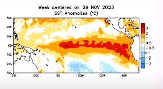
Here is a look at the SST anomalies from November 29th.


Now, over the past few weeks, the El Nino conditions have faded across the equatorial Pacific.

Here is a look at the SST anomalies  for February the 21st.


Currently in Nino region 3.4 the El Nino is considered weak to moderate.  However, while the El Nino is dissipating, the atmospheric conditions brought on by the El Nino, are going to linger, which means the warmer and wetter conditions experienced across the region during the winter should continue into the spring months.

The image below shows the ENSO regions across the tropical Pacific. The main region is seen in the image as the Nino 3.4 region. This area covers parts of the eastern and western tropical Pacific and is where the ENSO phase is determined.


We just can’t look at the surface, looking at the subsurface water temperature anomalies

December 19th


February 17th


We can see a large area of cold water is moving towards the surface.

The subsurface temperature changes have prompted the Climate Prediction Center to issue an official La Nina watch.

IRI ENSO Predictions Plume


With El Nino looking to quickly weaken through the upcoming spring, neutral conditions will end up taking over by the end of Spring, with the possibility of a La Nina developing for the during the summer into fall of 2024.

This will of course have ramifications on the 2024 Atlantic tropical season: I will discuss the Atlantic hurricane season in a separate blog post.

Madden Julian Oscillation (MJO)…

Currently the MJO is very weak and is inside the null circle, meaning it’s not exerting any forcing on the pattern. Looking at the MJO forecast from the GFS and Euro, we can see the MJO looks to stay weak, not putting any influence on the pattern at least through the middle of March.

GFS


Euro.  


The Polar Vortex…

We currently have warming in the Stratosphere. The Quasi-Biennial Oscillation (QBO) has been in (and still is) in the Easterly phase. This is the reason we had so many stratospheric warming events this winter. So, the current warming is no surprise.

During March, the QBO is going to weaken, and most likely will become westerly at some point, with the QBO becoming weaker, the tendency for PV disruptions is going to fade away.  

The current stratospheric warming is going to disrupted the PV, which will allow colder air to move into the Mid Latitudes. Like we saw during mid-January. But the problem is the cold air is looking to be deflected into Asia and Europe.

This means that we’re going to see the Pacific Jet become strong and very zonal. This will mean it will run roughshod over the Pattern over North America.

The same general pattern we saw during the winter, should stay with us as we go into Spring.


March…

March is always a transition month.  So, we’re typically on a rollercoaster. This year will be no exception. March will likely start out quite mild. Then we should see a flip to cooler temperatures. As has been the case during the winter, this cooler shot won't have a lot of staying power; but it could hang around for at least part of the 2nd half of March. March is likely to experience these fleeting shots of cool/cold air, but they will likely quickly be replaced with warmer temperatures. March should be quite active. Precipitation should average above average for the month. We haven’t had a lot of snow this winter. but I don’t think the Northeast into Middle Atlantic is completely out of the woods when it comes to snow, as I can’t entirely rule out the snow chances; perhaps even a bigger storm for part of the region. With that said, the pattern won’t be super supportive for snow storms.

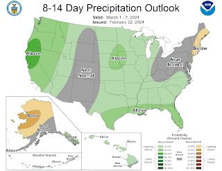
The NOAA temperature and Precipitation outlooks here take us to March 7th…


April…

For northern Pennsylvania and points north, temperatures could start out a bit cool, but overall temperatures should end up average to slightly above average for mid month.  Then there is a chance for colder air to invade as we go through the second half of April. But the southern Pennsylvania and Middle Atlantic will likely end up overall below average for the entire month. 

Precipitation should be generally above average across the Northeast into northern Middle Atlantic. the wet pattern will continue from March. Showers and storms will keep us watching the local river levels

Severe season could start early this year.


May…

Overall temperatures should average well above average across Northern parts of the Northeast. With temperatures above average across the southern Northeast into the Middle Atlantic. But we're likely still going to be on a Roller Coaster. 

Precipitation is going to be dependent on storms and where they form and track. But it looks like the pattern very well could support rain and storms. I think May will feature quite a bit of severe weather in the Northeast.  I do think there will be an elevated tornado risk in May, across Southern New England, the New York State Southern Tier, into Pennsylvania. 

Temperature outlook for March, April, and May.


Precipitation outlook for March, April, and May.