Monday, October 28, 2013

Looking back at sandy.

Tomorrow will mark the first anniversary of Super-storm Sandy's landfall in New Jersey.

Sandy was the largest Atlantic hurricane on record (by diameter), the second-costliest storm in U.S. history (Second  only Katrina), affecting parts of 24 states including the East Coast from Florida to Maine, and was responsible for more than $65 billion in damage, and caused 285 fatalities worldwide. Days before it was becoming apparent that New Jersey to Long Island were in danger of a landfall.
 
I remember looking at the models, satellite images and projection forecast and being spellbound  and fearful at the same time.

There is no doubt that that Sandy will live in infamy in the hearts of those who lived through her furry.


On October 22, 2012 a tropical depression formed in the southern Caribbean Sea. This depression intensified into Hurricane Sandy. Soon after, she made her first landfall in Jamaica. After interaction with Jamaica Sandy lost some of her punch. Over the next two days Sandy quickly reorganized before her second landfall on eastern Cuba reaching a peak intensity of  sustained winds of 115mph (a Category 3 hurricane).  Sandy then tracked almost due north. Along the way two cold fronts intercepted her. The first cold front interacted with Sandy three days before her destiny in New Jersey. At this point sandy stopped being fueled solely from warm water below. She also increased in size. Her wind field more than doubled in less than 24 hours. When she interacted with the second cold front her overall size exploded, she would reach an Atlantic Basin record with tropical force winds 1000 miles from her center.

She would have gone out to sea. But when the second cold front intercepted her,  phasing with a system moving through the TN Valley, along with a strong blocking high to her  north and East along with an ocean low to her east. Because of all of this Sandy instead made a  left hook into the extreme southern NJ coastline, near Cape May. She was now a hybrid mega-storm. When Sandy made landfall, it nearly set the record for the lowest central pressure measured north of the Mason-Dixon line in the United States.


Sandy's angle of approach was a worst-possible scenario. The angle and shape of the Coast ended up concentrating the surge, building the wall of water even higher. The hardest hit regions were the coastal sections of NJ and NY, record surges were recorded in New York Harbor. Sandy's wrath was felt for hundreds of miles inland. She was associated with a blizzard that dropped over 3 feet of snow in West Virginia. Sandy also caused record setting waves of over 20 feet and enormous surges in Lake Michigan.


Why did 285 people die?

There are many reasons. But there are two primary reasons. First, many believed Sandy would behave like Irene the year before...expecting some downed trees causing power outages and some high tide flooding. But by 7:30 of the 29th, everyone who hadn't taken the storm seriously knew they had made a possible fatal error in judgment. Second,  was how the NHC (National Hurricane Center) handled Sandy. They really didn't have  procedures to handle post-tropical advisories and faced many unacceptable options. In the end, the NHC  said the next advisory would come from the National Weather Service’s Hydrometeorological Prediction Center, a lesser known entity. This greatly increased the chaos and confusion. After a review, The NHC has revised their official definition of "Hurricane Warning.

Under the new policy, the hurricane center in Miami will continue to put out warnings and advisories if a storm threatens people and land, even if a hurricane or tropical storm loses its name and becomes something different.

The main lesson I want Y'all to take from this is Never but Never take any storm for granted......

Here is a link to a post on Sandy's timeline.

Here's another of the post I made on Sandy.


Rebecca

Friday, October 18, 2013

My First Thoughts on the 2013-2014 Winter Season.


We have a ways to go before real winter. But things are getting ready to cool off.  So here is my first thoughts on the upcoming winter of 2013-2014. These are my first thoughts on our upcoming Winter. This is not a forecast; rather it is, for all intents and purposes an outlook based on my thoughts as of now

Will this winter be like the non winter of 2011-2012, more like 2009-2010, or something in-between.

If you've read my other winter outlooks. You know there are various atmospheric/oceanic signals used to try and figure what the coming winter will be like..

Teleconnections:

ENSO:

One of the major forecast factors is always the state of the  late fall/winter El NiƱo-Southern Oscillation (ENSO). I've gone into more detail on what the  ENSO  is in past winter outlooks, If you want a more detailed explanation you can read them. Last year's can be found Here. For the purpose of this post, .ENSO refers to the relative sea surface temperatures (SST) in the eastern tropical Pacific Ocean.

When temperatures are cooler-than-normal we have a La Nina, which is by and large means a warmer and drier winter in the Northeast. During La Nina the polar jet stays up  around Alaska and then drops down into the Northern part of the US. During La Nina Arctic and Siberian air will at times intrude into the Northeast.  

When temperatures are warmer-than-normal it is called an El Nino, which is normally wetter and cooler across the Northeast. Outbreaks of very cold Arctic air are much less common during an El Nino winter.

This year, the SST is running close to normal, so as for an ENSO signal for the upcoming winter, it's keeping its cards close to the chest. So the ENSO look to be neutral. As you can see in the chart below. A Neutral ENSO is 0.5 above down to -0.5 below the center line.


During ENSO neutral conditions, the jet still can bring colder air into the Northeast. However storms don't get as much help from the  southern subtropical jet. One thing I've noticed is there is a lot of Greenland blocking during an ENSO neutral winter. Moisture out of the Gulf tends to move to the SE coast where it can move up the coast.  In a neutral ENSO the southern jet stream plays a huge rule in ice/snow events in the Northeast, timing of cold air outbreaks and storms is critical. 

These ENSO phases peak during the winter and early spring, but weaken as summer approaches. So even if an El Nino developed in January or February it wouldn't make a difference for snow in the Northeast. 

NAO:

Another important forecast factor is the North Atlantic Oscillation (NAO). The NAO is an index that measures the state of the Atlantic...it's the difference in pressure (placement of low and high pressure) between Iceland and Greenland down to the Azores and over into Spain. The NAO is a very good indicator of cold air in the Northeast. The only problem is the NAO can only be forecasted out 2-3 weeks. Last year, I described how I forecast the NAO for the winter...here. it is if you want to read about it and see how I do it.


Chart showing the two phases of the NAO.


PDO:

The PDO is based upon patterns of variation in sea surface temperature of the North Pacific; it's highly correlated with sea surface temperature in the northern California Current.  As with the other teleconnections , it has two phases. warm (positive) and cool (negative).

The phases normally persist for decades. But that changed in 1998. The PDO entered a cold phase that lasted only four years. It entered a warm phase of three years, from 2002 to 2005. The PDO was in a relatively neutral phase through August 2007, but unexpectedly changed in September 2007 to a negative phase that lasted for almost two years, through July 2009, because of a moderate El Nino event that developed at the equator during the fall/winter of 2009-2010. This positive signal continued for 10 months (August 2009-May 2010) until June 2010, when persistently negative values of the PDO initiated and have remained strongly negative since then.   


Why all of these wild swings in the PDO over the last 15 years? No one is really sure.


The QBO:

The quasi-biennial oscillation (QBO is a quasi-periodic oscillation of the equatorial zonal wind between easterlies and westerlies in the tropical stratosphere with a mean period of close to 30 months.

The QBO affects the polar vortex which in-turn affects the troposphere. The polar Vortex is a region of air that is contained by a strong west to east jet stream that circles the polar region.

Here is a chart that shows how the polar vortex can effect the weather across the North America.


I won't waste anyone's time on going into the QBO; if you want to learn more about it here is a paper.

There are recent indications that the QBO will head toward neutral. Looking back at past years, when the QBO moved to around neutral a negative NAO formed more times than not.

There are other things that go into an winter outlook: Past seasons, Tropical Activity, Arctic Oscillation (AO), The PNA (Pacific North American), among other things. I might show these in the next final outlook; but I don't want to get over technical.

Analog Years:

I looked at several years. Some of which were:1959, 1960, 1961, 1962, 1963, 1966, 1967, 1968, 1969, 1978, 1979, 2001, 2003, and others.

But for now at least, I found the years that matched up the best were the winters of 1961-1962, 1967-1968, 1968,1969, and 1978-1979.

Why those years? They were back to back neutral ENSO events, they were years that had a slow start to the tropical season, and all featured cold PDO's. There are other factors but those are the major ones.


Arctic Ice and Canadian/ Siberian snowpack:

Despite the warm start to fall, plenty of cold air has been building up around the Arctic Circle, Siberia and Western Canada. Right now, the amount of total snow and ice across the Northern Hemisphere is up to around 6.5 million square kilometers. That is above average by a bit more than 1 million square kilometers.

With the snow and ice, it's not surprising that a we see a pattern change coming. As I've been saying on my Facebook weather page, guidance suggests colder air will infiltrate the Midwest and Northeast, starting this weekend.  This theory is starting to show itself all the snowfall we've seen in some places in the Midwest.  

The Bottom Line:

To sum all of this up. I strongly expect to see high latitude blocking over Greenland. The ENSO, QBO, and other things does support this idea.

Our winter last year was largely ENSO neutral. Many times the winter was influenced by circulations other then the ENSO, mainly the NAO. For the winter of 2013-2014 could hold a few(maybe more than a few)  similarities to last year.

The long range models are showing  the cold outbreak next week will most likely stick around into the first part of November. But they are hinting at a warm up starting around mid November. But between now and then we could see some kind of snow event.

The Eastern US will likely see quite a bit of variability this season. But, the winter seasons really cold air most likely will get off to a slow start, then really start to ramp up around  mid-January through the end of the season. With the coldest air over the Midwest.  I do expect to see moderately cold air across northern NYS, Western NYS, And Northern New England for part of December into January.

The milder pattern during December and January will lead to more mixed precipitation events, for Southern New England, and Southern NYS, Southeastern NYS, Eastern PA, and Southern New England. But don't worry, the pattern will cool off for the 2nd half of winter.

As for snowfall, The pattern I  expect will allow for more clippers than average. Because of this, the Midwest and Great Lakes look to see above average snowfall for the upcoming season.  An active storm track through the Great Lakes during December and into a part of January is looking likely.  So, the lake snow-belts off of Lakes Erie and Ontario could do quite well.  The snowfall in the Mid Atlantic states, Eastern NYS, and Southern New England could only be below to near average this season. But do the high variability of the storms and cold air outbreaks, timing will have a lot to say about that.


These are just my first thoughts and subject to change. I will post my official outlook for the Winter of 2013 - 2014 in November.


Rebecca


Tuesday, October 1, 2013

what happened to the hurricanes?


Everyone's Atlantic  hurricane forecast for 2013 were calling for above normal to way above normal activity.

 For the 2013 hurricane season NOAA’s Atlantic Hurricane Season Outlook predicted the following:

70 percent likelihood of 13 to 20 named storms (winds of 39 mph or higher)

7 to 11 would become hurricanes (winds of 74 mph or higher)

3-6 major hurricanes (Category 3,4, or 5: winds of 111 mph or higher)


Respected veteran hurricane scientist Bill Gray and his team at Colorado State University

called for 18 named storms during the hurricane season, between June 1 and Nov. 30.

Eight of those are expected to become hurricanes.

Three of those are expected to become major hurricanes (Saffir / Simpson category 3-4-5) with sustained winds of 111 mph or greater.

Believe it or not, this is a slight reduction from the early April and early June forecasts when the team called for 18 named storms, nine hurricanes and four major hurricanes.

 I said, I was using the weather patterns of past years and decades, along with other factors to make my tropical outlook. 

Since 1950 the years 1952,1996, 2007, and 2008 had very similar oceanic and atmospheric characteristics to those forecasted for this years tropical season.

My forecast was this:


"This season will be quite active with 13-18 named systems, with 8-10 becoming hurricanes, four or five (perhaps more) of which will make landfall somewhere in the U.S. Also, I feel 2-4 of these will strike or impact the Northeast and northern Mid Atlantic states. Of the 13-18 named storms 3-4 will be major hurricanes. Once we get toward the end of July and onward I think the season will become quite active. "

So far, named storms in the Atlantic basin hasn't lived up to mine or anyone's expectations , Jerry makes our 10th named storm for the season... this is above average

But, we've only had two hurricanes so far this season....Humberto briefly became a hurricane Sept. 11, a Category 1 with winds under 95 mph. It was named a hurricane just three hours before it would have been the latest first hurricane since the satellite era. The other hurricane was Ingrid Which momentarily became a Category 1 before landfall in Mexico.

So while activity is above normal, the intensity of these tropical cyclones hasn't come any way near what was forecasted.
 
 
                                           Tracks for the named systems for the 2013 season
 

 With records going back to 1851, Dennis Feltgen, a spokesman for the U.S. National Hurricane Center, said there had been only 17 years when the first Atlantic hurricane formed after Sept. 4.

Feltgen  said "The all-time record was set in 1905, when the first hurricane materialized on Oct. 8".

In an average season the seasons first hurricane shows up by Aug. 10, with the second  hurricane quick on its heals on Aug. 28 and the first major hurricane normally forms by Sept. 4.

As I've said in post and on my Facebook page, since the dawn of the satellite era, started in 1967.  Hurricane Gustav set the modern record on September 11, 2002 as the latest date for the first hurricane to arrive.

The Accumulated Cyclone Energy index -- a rating system that compares the intensity of storm seasons -- would normally be around 55 for the Atlantic. It's now a paltry 16. Globally the rating is a stunning 255, roughly half of what we should see this time of year.

normally when an ocean basin kicks up a fuss on one part of the globe, usually another ocean basin is quiet. Nature tends to balance itself that way. This year, according to the ratings, storm activity in all the world's ocean basins is below normal.


So what is going on?

We had a very strong  Bermuda high for most of the Summer...This helped  suppresses tropical cyclone development.

Most of the season has seen a very stable atmosphere over the tropical Atlantic.

In a normal El Nino year the tropical water in the Pacific west of South America are warmer than normal, this leads to a lot of wind shear across the Caribbean , which suppresses Tropical Cyclones

Now while, this has not been a El Nino year, the waters in the tropical Pacific have been above normal, perhaps this has something to do with all the wind shear we've been seeing.

The location of the Jet Stream for a good part of the Summer had been farther south than average

Making it wet in both the Northeast and Southeast along the Eastern Seaboard... this could also be helping in creating shear......

There also has been an ongoing   drought in northeast Brazil.

These could have had a major role in the placement of the Tropical Upper Tropspheric Trough  (TUTT) for the 2013 season.

TUTT is an upper level trough that helps with convection in the tropics

It  is normal to see it over the Atlantic and Pacific for part of the year.

The location of the TUTT is key as to if it will aid or hinder tropical cyclone development

TUTT helps support vertical wind shear.. Normally south of the TUTT you have strong westerly wind shear ...Tropical cyclones don't like environments like that.....But north of the TUTT the wind shear is normally less...so tropical cyclones that form there have a better chance for development.

The TUTT isn't always bad, there are times when they can help build better outflow of the storms center.....there have been times where the TUTT became cut off and became a tropical cyclone.

TUTT over the Atlantic basin first appears in June, strengthens in July and August, and then weakens in September and October. During August (the start of prime time for Atlantic tropical cyclones), the TUTT tilts from southwest to northeast, spanning from Cuba to roughly latitude 35 degrees North at around 250mb

This season there were several times where the placement of the TUTT caused  strong west and southwest winds aloft which helped suppress tropical cyclone development.  

 
The SAL layer... I feel this was the biggest factor this year.... tropical storms and hurricanes develop and intensify by feeding off warm, rising, moist air. But, the Atlantic's hurricane breeding ground has been dominated by dry, sinking air for much of the summer....normally you don't see these huge dust storms coming off the African Coast during the hurricane season...... The High pressure in the Atlantic was too far north... if it had been   farther south it would have forced the air to come off the Congo instead of the Sahara Desert ...The  Congo is all rainforest, therefore it has a lot more moisture......this would have been much more conductive for tropical cyclone development.
 
I don't like to see death and destruction, so a slow season is a good thing. one thing I want to mention is the almost always present high pressure over the eastern part of the Country has helped protect the Northeast from the few storms that did form.

 From the hurricane climatology standpoint, storms ordinary form closer to the U.S. coast later in the season, like Hurricane Sandy last year.”

Looking back at the records, in the past 60 years there have been three seasons with no named storms at any time from September 20th through September 26th: 1991, 1997 and 2009. All of these were El Nino seasons, however, there have been other El Nino seasons during this 60 year period - including 2002 and 2004 which were active seasons. In 1993, a slightly positive ENSO Neutral year, there were no named storms after September 21st. So far, 2013 is a slightly negative to an Neutral  ENSO  season.

Looking at the Teleconnections, most of the same atmospheric conditions that have so far interfered with tropical cyclone development could persist into November.

Looking at everything, I don’t see any significant changes for the Atlantic Basin for the rest of the 2013 hurricane season.   But we will see.
Friday, August 23, 2013

Is The 2013 Atlantic Hurricane Season Over?

The 2013 Atlantic Hurricane Season so far...we've had five named storms. The beginning of the season got off to an above average start. Then we slowed down during August, after a busy June and July.

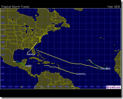
Here is a chart showing the track of the five named storms so far this year.

 track  

Andrea went from 5Jun-7Jun, She got to 63mph with a pressure of 992mb.
Barry went from 17Jun-21Jun, winds between 51-52 mph and a pressure of 1003mb.
Chantal went from 8Jul-10Jul, winds of 63mph pressure of 1005mb.
Dorian went from 24Jul-3Aug, winds got to 57 mph and a pressure of 999mb.
Erin went from15Aug-18Aug, her winds got to 40 mph with a pressure of 1006mb.

Why has the season acted the way it has?

This season we've seen a lot of wind shear. Also the SST was only marginal for supporting tropical cyclones. But the main reason has been the air in the Central Atlantic has been unusually dry this season.  Many are throwing in the towel on the 2013 Atlantic hurricane season. Saying if the tropics don't heat up soon, the season is over. Nothing could be farther from the truth.

Climatology speaking we're only getting into the peak Atlantic tropical season. The Atlantic hurricane season runs from June 1st through November 30th. ( Originally the season went from June 15 -October 31. Over the years the start shifted to June 1st and prior to 1965 the end date was November 15. ). Peak season is from August - October. 

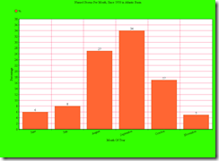
Here are a few Charts I made up. Source is the NHC data archive.

 named storms per month chart

The above chart shows how the numbers breakdown for named storms during Hurricane Season in
the Atlantic Basin.

   Named storms since 1950

The chart above shows that vast number of named storms develop Aug -Oct.

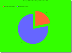
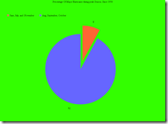
  Precentage of Hurricanes since 1950

The above chart shows that 84% of Hurricanes form during peak season.

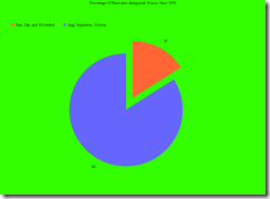
  Precentage of major Hurricanes since 1950  

The above chart shows the vast majority of major hurricanes occur during peak season.

A major hurricane is one that has at least sustained winds of 111 mph. 

Peak season is when tropical cyclone killing vertical wind shear is at its lowest. It's also the time when generally instability is at its greatest. It takes the waters of the Atlantic a few months for the SST to warm enough and deep enough to really be able to support tropical cyclones.  Aug 10 is the average date for the first Atlantic hurricane, according to this data.

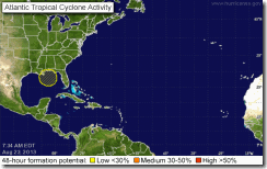
Today there are no tropical cyclones out there in the Atlantic Basin... Just a little blob in the Caribbean that the National Hurricane Center (NHC) is giving a 10% chance for more tropical development. This is what's left of the tropical wave that went through the Keys on Wednesday. As of this writing the upper level low does look like it wants to organize, so we will see. But of more importance is the fact that the Tropical Waves over Africa are getting stronger.


    atl_overview  

Things can change very quickly in the tropics. So give it some time and it may get there. With that huge ridge of high pressure All it takes is for one tropical cyclone to stay alive and reach the Western Hemisphere , and it's game on.

looking back at past seasons.

There have been several tropical seasons that started off slow. In 1992 no storms formed until late August. Another year that had a slow start was 1954. In 1954 Carol was the first hurricane to form. She developed from a tropical wave near the Bahamas on August 25th. The 1954 hurricane season was a bad one for the East Coast/Northeast. If you want to read about the 1954 season here's a link.

Just because the season is half over, doesn't mean the Northeast is off the hook. Even though major hurricanes are rare in the Northeast they have and do occur. Back in 1821 on September 3rd a category four hurricane slammed into the State of New Jersey at Cape May. The Hurricane made four land falls: Virginia, New Jersey, New York, and Southern New England. New Jersey experienced wind just of 200 mph. 

In 1869 Hurricane 7 reached 115 mph with a central pressure of 950mb. The hurricane grazed Long Island and made landfall on southwestern Rhode Island.

Then there's the great Long Island Express ( Yankee Clipper) That made landfall on Long Island on September 21, 1938 as a category 3.

The last major hurricane to strike the Northeast was the before mentioned Hurricane Carol . Also during 1954 Hurricane Edna was just below major hurricane strength when she slammed into Massachusetts, just 11 days behind Carol.

The point I'm making is hurricane season in the Atlantic Basin is far from over. And anything can happen. And calls for the seasons demise are premature. All it takes is one hurricane to make landfall near you to completely change your life. So don’t drop your guard. We've seen deadly seasons that started late. Could this be another one, only time will tell.      


Rebecca.


Wednesday, August 7, 2013

The tropical season so far, and what is yet to come.

The season so far:


So far, there have been four tropical cyclones in the Atlantic Basin. Now while it may seem we're off to a slow start; we're slightly ahead of the historical average curve. The fourth named storm has typically formed past mid August to the end of August. in fact two of these tropical storms were Cape Verde storms. it's rare to have Cape Verde storms before June, must less two. But they do occur.


Cape Verde Season:

Before I get into the Cape Verde season; I want to discuss what a Cape Verde type tropical cyclone is.

Cape Verde storms develop from tropical waves , which form in the African savanna during the wet season and move into the Atlantic Basin and become tropical cyclones within 550 to 620 miles of the Cape Verde Islands.


When we get into the heart of Hurricane season in the Atlantic Basin, we start to watch around the Cape Verde Island in the Western Atlantic just off the coast of Africa. Normally Cape Verde storms occur in August and September, but as was the case this year they can form earlier, or later in the year.


Why are the tropical cyclones having problems developing?

The reason is wind shear and water temperatures, in a nutshell, it's the dry Saharan air layer.


Wind Shear:


wind shear is generally the most essential contributing factor when it comes to tropical cyclone formation. Generally, wind shear refers to any change in wind speed or direction along a straight line. When we're dealing with tropical cyclones vertical wind shear is what we watch . We monitor the difference in wind speed between 200mb layer (around, 40,000 feet) down to the 850mb layer (about 5,000 feet ). You can find these charts on Tropical Page of the Blog/website.


Tropical Cyclones are basically just heat engines powered from the latent heat that is released from water vapor turning into liquid water.


when shear is low, the storms latent heat is focused over a small area of ocean, the lack of strong vertical wind shear allows the storm to grow tall right over the top of this latent heat . But when the wind shear is high (more typical in an El Nino year), the storms latent heat is focused over a much larger area of ocean, the stronger vertical wind shear blows the top of the storm away from its center, make the storm much less efficient in its handling of heat.


So vertical wind shear effects tropical cyclones by removing the heat and moisture they need from the area near their center; this disrupts the inflow and outflow of the tropical cyclone.


Water Temperature:


Several important ingredients are needed for a tropical disturbance to become a tropical cyclone and later strengthen into a tropical storm or hurricane:


1.A tropical disturbance with thunderstorms.


2.A distance of at least 300 miles (500 kilometers) from the equator.


3. Water temperature is the biggest limiting factor in the early part of tropical season If you remember your Earth Science from grade school, then you remember that water warms slower than the land. Therefore, late summer and early fall is the time for the most favorable water temperature for tropical storm development. As most of us are aware, normally Atlantic Basin cyclones form in the area between the West Coast of Africa and the Caribbean, along with the Gulf of Mexico (GOM). Hurricanes thrive over warm water; the warmer the better. Tropical cyclones are fueled by warm water evaporating into the air;  water temperatures 80 degrees (F) or greater will enhance tropical development. Typically you want those warm Ocean temperatures down to a depth of at least 164 feet (50 meters) below the surface.


4.Lots of moisture in the lower and middle part of the atmosphere.


5. And as I just explained low wind shear.


In September Atlantic sea-surface temperatures (SST) typically reach maximums of about 83.3°F (28.5°C) along a band centered at about 7°N


As I said above, we're entering what is typically called Cape Verde season. The reason it's rare to see Cape Verde tropical cyclones before August is It takes a while to warm up the waters off the African Coast to 80 degrees F, deeper than 25 feet.


However, recently, the water temperature has been a few degrees below average near the Antilles.  


The Saharan Air Layer (SAL):


Every year a mass of very dry, dusty air which forms over the Sahara Desert and Sahel regions in Northern Africa during the late spring, summer, and early fall. Normally this dry and dusty air mass moves out over the tropical North Atlantic Ocean every 3-5 days. As this air mass advances westward and emerges over the Atlantic off the northwest African coast, it comes into contact with cool, moist low-level air and becomes the Saharan air layer (SAL). Also, known as Saharan Dust.
 

The SAL can have a significant negative impact on tropical cyclone intensity and formation.


The inclusion, or drawing in, of dry air into a tropical system. can act to weaken a tropical cyclone by forming downdrafts around the storm.


The surge in the mid-level African easterly jet can substantially increase the vertical wind shear in and around the storm environment.


Since one of the key ingredients for tropical cyclone development is a deep feed of moisture, Saharan Dust often acts to inhibit tropical development.


Because the SAL aids in reversing the trade winds which helps to stabilizes the atmosphere. The more stable atmosphere is the harder it is for tropical convection to develop.


As you can see there is a lot of Saharan Dust over the Atlantic. This will make it hard for tropical cyclones to move west.

The three factors I mentioned: wind shear, water temperatures, and the SAL has prevented the season from really taking off.


Looking ahead:

The global models are hinting that the Atlantic Basin will be become more active around mid month.


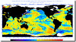
Here is a look at the current SST in the Atlantic Basin. The water temperatures are starting to run slightly above normal for this time of year. this would help increase tropical cyclone activity.


sst anomnight_current large


We still have a lot of Saharan Dust out over the Atlantic. And as I just showed this dry air will help to inhibit tropical development   Moisture levels in the Caribbean and western Atlantic are drier than they should be.

The ENSO:

ENSO stands for El Nino/ Southern Oscillation. The ENSO cycle refers to the coherent and sometimes very strong year-to-year variations in sea- surface temperatures, convective rainfall, surface air pressure, and atmospheric circulation that occur across the equatorial Pacific Ocean. La Nina and El Nino represent opposite extremes in the ENSO cycle. ENSO is known to affect tropical cyclones in different ways around the globe.


El Nino refers to the above average SST that develop across the east central equatorial Pacific. It is referred to as the warm phase of the ENSO cycle.


La Nina is the below average SST that develop across the east central equatorial Pacific. It's the cold phase of the ENSO cycle.


ENSO neutral is when the SST, rain fall patterns, and wind patterns over the equatorial Pacific Ocean are near the long term mean.

 
In spite of the recent slight cooling, it does not appear a La Nina — or an El Nino — is underway. The subsurface temperature anomalies under the equatorial Pacific have changed little over the past few months. So the ENSO is currently cool/neutral, and if it remains neutral, an El NiƱo will not inhibit development of storms in the Atlantic for the rest of this season. Relative to neutral events, the frequency of hurricane landfalls along the East Coast is found to increase (decrease) during ENSO cold (warm) events. This is consistent with previous studies linking ENSO and Atlantic hurricane activity. But there is still a chance El NiƱo conditions may develop and suppress activity somewhat in the latter portion of the season.


The MJO:

The MJO (Madden Julian Oscillation) is a planetary-scale quasi-periodic oscillation of atmospheric wind and convective cloudiness anomalies that moves slowly eastward along the equator mainly over the tropical Indian and Pacific Oceans with a timescale on the order of 30–60 days.

The MJO is broken into 8 phases which begin over Africa and move eastward.

The MJO phase diagram illustrates the progression of the MJO through different phases. Phase diagram shows the evolution of the last 40 days of observations along with the 15 day forecasts from the constructed analogue (green), autoregressive model (AR), and lagged linear regression (red).
The thick (thin) lines represent the statistical model forecasts for the first 7 days (last 8 days) respectively.

RMM1 and RMM2 are just mathematical algorithms that combine the amount of clouds and winds at various levels of the atmosphere to provide a measure of the strength and location of the MJO (you don't have to worry about it). When the index is within the circle in the center; the MJO is considered weak, meaning it is difficult to discern using the RIMM algorithms. Outside of this circle the index is stronger and will usually move in an anti-clockwise direction as the MJO moves from west to east.  

The Main thing to get out of it is, when the MJO is in phases 1-2, activity in the Atlantic typically picks up, and when it’s in phases 6-7, Atlantic activity decreases. When it's in the other phases, everything more or less averages out (neutral).  If you look at the diagram you can see it is forecasted to head into phases 8 and/or 1. If this does occur, we would see more tropical activity in the Atlantic by mid-August.


   NCPE_phase_21m_small MJO  


Based on all of this, I think we will see an uptick in Atlantic tropical activity as we get around mid month. As far as the season goes I think we will still see above average tropical cyclone activity in the Atlantic Basin.. but perhaps only slightly... My 2013 hurricane outlook might only verify on the lower end.... I guess time will tell.  


Rebecca