
We've had a lot of cold in the Eastern US during winter
2014-2015, especially in the Great Lakes and Northeast.


I've been laying out the march pattern for quite some time
on the Facebook page. on how the cold in the east is going to hang on until we
get past Easter; Then we will see the eastern trough retrograde to the west.
March will see a constant battle between the warm and cold
air. This will lead so some melting,
then more snow and ice, then more melting.
The warm Sea Surface Temperatures (SST) off the West Coast
and up into the Gulf of Alaska, are the result of the persistent positive PNA
in the Pacific. The PNA is the reason
for the strong ridge over western North America. The Trough over eastern North America, has
allowed for record breaking cold for the February and March period.
As we approach Mid April, we will see the eastern trough
moving into the plains and Rockies. Because of this movement, the Atlantic
ridge will retrograde west over the Eastern Seaboard. With the Western ridge holding more or less
in place.
Cold air is very dense, and it can be very hard to dislodge.
We also have El Nino.... typically during El Nino's we see below average temperatures in the Northeast and Great Lakes.
The Atlantic Multi-decadal Oscillation (AMO) has a big impact on moisture distribution across North America. AMO also is one of the major contributors to air temperature in the Northern Hemisphere. There is a strong correlation that shows when the AMO is positive the eastern US is warmer, and when it's negative the East Coast is colder.
The most sustained number of low AMO levels was during the
cold spell of 1902 -1925 and again from the mid 1960's to the late 1970’s.
The AMO typically has long duration phases that last for
decades. This will aid the overall temperatures to be below seasonal averages
for April, May and June.
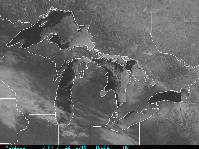
The Great Lakes saw a lot of ice this winter season. As of
this writing, other than Lake Ontario, the four other Great Lakes still have a
lot of ice on them. Our inland lakes,
rivers, and streams, have lots of ice as will.
The Chesapeake Bay waters and ocean temperatures are running cooler than
normal after a brutally cold winter.

From what I see This spring is going to see April below
average in the temperature department; this is partly due to the really below
average temperatures in March. But
remember below average in April is not the same kind of cold that is below
average in March. So while Spring will
have a slow start for the first part of April. once we get later into April and
head for May, we will begin to see the pattern change to a milder one but
slowly. With the transition comes the
increasing potential for severe weather. I will touch on the severe weather
potential later in the outlook.


The signal is pretty strong for May to be our first warm month in a
while. With the transition comes the increasing potential for severe weather,
especially with a cold pool remaining in close proximity to our north. As we head into the end of April into the first part of May, temperatures look to become below average again. Then later in May and June will see temperatures that are
more seasonal. The Temperatures in June should be average to slightly just below average.
The active southern pattern will lead to above average
precipitation over the Mid Atlantic, Pennsylvania, and southern and central New
England. While much of New York State and northern New England will see normal
to below average precipitation. For the rest of March into the first 10-12 days
in April, due to the active southern storm track and the abundance of arctic
air that will linger and be slow to dislodge, storms will have to be watched carefully,
due to the possibility of snow.
Flood outlook:
New York State, and New England saw snowfall accumulations
will above average. and while the Mid Atlantic was late to the party they too
have ended up with above average snowfall.
The Tug Hill still has a deep snowpack; as does northern New
England, especially in the higher elevations. Western New York State and eastern New England
have see significant snowfall accumulations. The lakes, rivers, and streams
have thick ice.


At my place on the Tug Hill there is still a very deep
snowpack... with 10-14 inches of water locked in that snowpack. The deep snowpack isn't just an issue for the
high elevations western New York State and eastern New England have a deep
snowpack that has 5-8 inches of water locked in.
With the cold winter, came the ice. As I said we have a lot
of ice on the streams, rivers, and lakes. We winter hanging on into mid April,
we will be very susceptible to late season ice breaking up on rivers in
northern New York and northern New England, resulting in ice jam concerns.
NOAA has placed Central and Southern New England, as well as
areas south of Lake Ontario at heightened risk for moderate flooding. But all in all there isn't a huge risk for above-normal
flooding , unless we see a quick warm up, The longer the cold stays in place
the greater the likelihood of flooding. Let's hope for a gradual warm up.

Severe Weather:
The current pattern doesn't support severe weather. But the pattern gets more advantageous once we
hit the middle of April.
Typically in March we see an uptick in tornadic severe
weather. That hasn't happen this year. In fact tornado activity this year is at
near record low levels. As of this
writing, there have been no tornadoes this March. This is due to the persistent
trough over the eastern half to the CONUS. This hasn't allowed for instability to develop
in the southern Plains and southern states. Strong instability is formed when
warm/moist and cold/dry air is in close proximity.

On average, around 1,300 tornadoes hit the United States
each year. The last couple of years have
seen below average tornado activity.

The Gulf of Mexico (GOM) has very warm SST. In fact, the
water temperatures in the GOM are well above average for this time of year.
Once we get past Easter, we're going to see the trough
expand to the west, The ridge over the Atlantic will retrograde west as well.
Here is the current run of the GFS showing the pattern at
the end of March. The GFS seems to have a good handle on this at this point,
but I do think it is underplaying the cold in the Midwest and Plains. However the GFS is mishandling the pattern as
we get past Easter. I've drawn a rough
map showing how I think the ridging and trough will look in the April 7 -10
time period.


Once the trough retrogrades to the west, warmer air and GOM
moisture will be able to advance north, The warm waters off the west coast aren't
going to allow the ridge over the West Coast to move too far west. So we're still going to see cold air slide
down the eastern side of the ridge, only this time the trough will have be
pushed back into Plains and eastern Rockies.
As the cold dry air and the warm moist air interact, it's going to. increase
the instability of the atmosphere.
As I said, we've had a slow start to the severe season, with
stable air hanging around longer into the spring season. However, once we get
into the first part April, this will change in a big way.... Then I think we're going to have the tornadoes counts lessen for a few weeks.... But I do think once we're into the spring season tornado activity will increase compared to the last couple of years, once
we get past mid May and into June. The focus of this will be over Dixie Alley and
the Mississippi and Tennessee Valleys.
I can't predict which storms will be tornadic. But all the
players will be in play that lead to their formation. I really do think the
stage is being set for some decent severe outbreaks.
New York State and Pennsylvania, then followed by New
England, see an uptick in our severe weather as we get closer to June.
Many of our larger Northeast tornado outbreaks have occurred around Memorial
Day. Too soon to say, how our severe season will be up here.
As always, I welcome your feedback and questions..