Monday, October 29, 2012

Sandy’s record low pressure for a Northeast hurricane.

I thought I would post a quick post on Sandy. This will cover air pressure and why the winds are stronger on the right side of a hurricane. But first I will talk about Sandy.   

How do you calculate a potential disaster?

 First, add a strong wintery cold front coming in from the West. Second, include a high-pressure ridge off the coast of Greenland is keeping the storm from the usual course away from the U.S. mainland. Third, Sandy is an extremely low-pressure storm giving it extra form and punch than would normally be found with a 90 mph storm. Finally, add a nearly full harvest moon to exacerbate tidal effects In low lying areas.        

Hurricane Sandy’s affects are being felt along the entire east coast and by everyone east of the Mississippi river. As expected once Sandy got back over the warm Gulf Stream that flows parallel to the U.S. East Coast last night and this morning , She exploded in size and power. On satellite she is looking increasingly big and scary. Her central pressure is 940 mb, this is something you would normally see in a Category 3 or 4 hurricane. She is a few miles from Cape May, NJ where she will make landfall. We will see tropical force winds and gust to hurricane force, especially for those over 1500 feet in elevation. We will be feeling the effects of Sandy for the next 30 to 48 hours.    

Why worry about Sandy’s pressure?    

The lowest atmospheric pressure ever recorded at sea level was an astounding 870 mb, That's around 140 mb below what is considered normal. This pressure was measured at the center of Typhoon Tip in the North Pacific in 1979. Why is that astounding? Who cares about air pressure measurements anyway?     To answer these questions, we must understand a couple of ideas. Every place on Earth has a measurable, atmospheric pressure. The pressure at that location is caused by the weight of the column of air above that location. Typically, meteorologists measure atmospheric pressure using barometer. The weight of the air above the Earth is equal to the weight that is shown on the barometer. This column's height can be precisely measured. Standard, sea-level atmospheric pressure is 1013 mb. This amount of air pressure on the barometer is 29 59 / 64 .inches high. Air pressure decreases as we rise above the Earth because there is less air above us the higher up we go. But atmospheric pressures can change at the surface of the Earth as well. They go up and down by small amounts and cause the "highs" and "lows" you hear about on weather reports.       Under normal conditions and over a normal period of time, the atmospheric pressure usually changes no more than 20 mb The mercury in the barometer usually rises or falls only a little bit in a period of 12 to 24 hours. But even small differences in atmospheric pressure cause the air to be pushed around. This air movement is called wind. In this way air pressure and wind are closely related. Wind moves out of areas of high air pressure and sweeps into areas of low air pressure. The greater the difference in air pressure from one place on Earth to another, the stronger the wind.    


How does a hurricane work?


  hurricanediagram The atmospheric pressure in the eyes of hurricanes is lower than in the surrounding atmosphere, so air spirals inward in the form of strong surface winds. If the center of low pressure is over warm ocean waters, the spiraling winds whip up waves and froth. This adds to the already high levels of water evaporation. The warm, wet air spirals in toward the center of the storm and then cools as it rises The water vapor the air is carrying condenses and forms clouds and rain (grey areas in the illustration). As the condensation evaporates, it again heats the rising air, causing the air to rise upward even faster. The expanding air rises to altitudes of 6 to 9 miles. Then, as the air cools, it flows outward over the top of the storm. This cool air flow outwards, lowers the weight of the air above the storm's center even more. These winds, drawn in from hot air spiral up the wall of the eye. These hot rising winds circulate at speeds of 30 mph. The strongest winds, with gusts of up to 225 mph are found beneath the eye wall, immediately outside the eye.

As long as the hurricane is over warm water, this cycle continues and tends to get stronger. The pressure in the storm's center gets lower and lower, and the winds blow faster and faster. The air in the eye of the hurricane is at low pressure, and is calm. As the eye passes over, the winds may drop altogether, and a small circle of clear sky may be visible overhead for a short period of time.  


Why are the strongest winds in a hurricane typically on the right side of the storm ?


radar811
The right side of the storm is defined with respect to the storm's motion: Take Sandy, she is moving to the west, the right side would be to the north of the storm; if the hurricane is moving to the north, the right side would be to the east of the storm. In general, the strongest winds in a hurricane are found on the right side of the storm, especially the forward right quadrant because the motion of the hurricane also contributes to its swirling winds. Hurricane sandy with a 90 mph while stationary however you have to add the forward motion of 28 mph in to the calculation. For Sandy the forward right quadrant could have Surface winds of 118 mph. Conversely, in the forward left quadrant of the storm,, the storm motion subtracts from the surface wind speed, which would be in Sandy's case 62 mph.


I will close on this, listen for any warnings given, and if you are told to evacuate, do so right away. Please stay safe!


Rebecca


Thursday, October 25, 2012

Sandy looks to strike!

Here is a quick blog post on Sandy.

The current 2:00  pm update have Sandy's winds at 105 mph with a central pressure of 963 mb. She is moving north at 20mph.

Sandy had very rapid development after she went through Jamaica. She hit Cuba as a 110 mph Cat 2. I had thought she would hit with winds no higher than 90 mph. I thought this because the storms had underperformed this year in relation to the computer guidance. It now appears that the Euro was right all along. I thought she would be strong a tropical storm; when she left Cuba and reemerged back over the Atlantic. Because of that I thought she would lose her warm core when she pulled north of North Carolina. That will no longer be the case. She looks to have a lot of warm core characteristics. Also as she loses some of her warm core characteristics, she will increase her size, so the wind field will be much larger. A tropical system has its strongest winds around it's center. Because Sandy will be some kind of hybrid this will not be the case. So the exact point of land fall will not be as important because of the large wind field.

History can show us how dangerous and damaging a warm-core hybrid can be. The 1938 Long Island Express (The Great New England Hurricane) and the 1991 “Perfect Storm”. I'm not saying Sandy will be anything like those two storms; I'm just showing you examples of what a hybrid can do.


storm_18 The spaghetti plots


 With the strong Rex Block, Tony to her east, and the fact that she is stronger will allow her to stay to the west side of the projected track. This will keep her close the East Coast. Something else Sandy might do is develop frontal systems which is something you would expect from a Nor'easter. We also will have the arctic air mass moving south and pushing the jet stream with it. This will cause widespread strong winds in addition to Sandy's winds. So even if Sandy passes you by you will still have to deal with strong winds. The arctic air will also allow for Snow in parts of the Mid Atlantic states into the Northeast. There is also the rain, How much rain we get will of course depend on where she makes landfall. Monday will be astronomical high tide. So the coastal surge could come inland quite at bit and cause a lot of damage.


TropicalAtlanticIR Sandy should be around the Carolina's Saturday. This is when we will have a better Idea where she will hit along the coast. if she is close to the Carolina's Maryland and western Long Island would probably be at risk for a landfall on Sunday. However if she looks to moving away from the coast her hit would most likely be in New England on Monday.


The center of the track cone is New York City. But I encourage you not to focus on the center. There is a lot of real estate between North Carolina and Massachusetts. So don't panic just beware and prepared


NOAA's recommended items in a basic emergency supply kit:

Water, one gallon of water per person per day for at least three days, for drinking and sanitation

Food, at least a three-day supply of non-perishable food

Battery-powered or hand crank radio and a NOAA Weather Radio with tone alert and extra batteries for both Flashlight and extra batteries

First aid kit

Whistle to signal for help

Dust mask to help filter contaminated air and plastic sheeting and duct tape to shelter-in-place

 Moist towelettes, garbage bags and plastic ties for personal sanitation

Wrench or pliers to turn off utilities

Manual can opener for food

Local maps

Cell phone with chargers, inverter or solar charger    


Well that’s it for now.  


Rebecca


Tuesday, October 23, 2012

Sandy will she come and visit the Northeast?


I thought I would post a very quick update on Sandy.


Sandy:


Here is the latest Euro model run.


 17106_3576024169309_1032298207_n I think we can agree this looks very ominous. But it is only one model. We have 6 days where lots of things can change. The weather models have had some trouble handling tropical systems this year. Also, no storm that was once a hurricane has made a Northeast landfall after September, going all the way back to 1900.


The track forecast from the National Hurricane Center has not changed. Winds are 50mph, central pressure is down to 993mb, she is moving north northwest at 8 mph. The tropical storm wind field extends 90 miles.

 Here  is a little on Sandy. I think it is fairly safe to say most of us have been thinking and talking about Sandy and what she might do.   While she is only moving at 8 mph now, she will pick-up speed has she moves north over the next few days. She will be moving into an area where there is little in the way of vertical shear and the Sea Surface Temperatures are over 80 degrees. So she should become a hurricane around Jamaica.

We're going to have a negatively tilted trough moving south during the later part of the work week. What this trough does will be critical to Sandy's track.

The European and Canadian models are very amplified and show Sandy interacting with an arctic air mass and pull the storm inland, phasing it and dragging down unseasonably cold air. The earlier GFS runs had Sandy farther east and out to sea. However, As of this writing, the 18z GFS run had a major shift westward. It remains to be seen if it will shift more to the west or trend back to the east. As for the QPF, we only have to look back at Wilma to know what can happen when tropical moisture rich air, meets cold arctic air.....Lots of heavy snow...... in-fact some of the models are showing QPF amounts of 6-10 inches of precipitation. The Euro and Canadian have a very tight < 950mb pressure gradient , throw in the highly supportive low level jet , cold 0C H85 Temperatures, and dropping surface temps. It doesn't take much imagination to see snow in parts of Pennsylvania, New York, and New England. How much snow there is (if any) will depend on Sandy's track and intensity.  


 Severe weather:

We will also have severe weather Friday and Saturday in the Midwest. The Trough that is going to affect Sandy will also kickoff a bit of severe weather. An upper level low will be moving into the Plains. Cape Values will be marginal as will lapse rates. But, there will be a lot of shear and moisture in place. There will be enough directional shear that any thunderstorms that do develop will start to rotate. Right now, I think the major treats will be wind and hail......but there will be a few tornadoes thrown in as well. The upper level low will bring snow to the Great Lakes.

So what is the bottom line:

There isn't one really, there are still details to be ironed out. But the chances of a Northeast hit from Sandy, have gone up a notch.  I think the 00 GFS will come into alignment with the Euro. One thing I want to mention, the models are only a tool, there are many factors in play, only some of which I've mentioned here. We have a lot of time for things to change. One only has to look back at Isaac and New Orleans, the models will still making adjustments at land fall, so don't panic.   I will continue to watch the upper air patterns and see what the models do.

That’s about it…….I will post more blog updates as we get closer to the weekend.


Rebecca


Tuesday, October 9, 2012

Air Masses, Weather Fronts, and Surface Charts

Hi Rebecca here again, I’ve mentioned weather fronts in my blog post and on my Facebook page.But, I thought, I would write a post that talks specifically about the different types weather fronts. I will also touch on isobaric analysis.


Before I get into fronts. I want to briefly mention the types of air masses:


An air mass is a very large body of air with similar temperature and moisture characteristics. Air masses are placed in categories based on the region where it has been over long enough to pickup the temperature and moisture characteristics of that region. Air masses don’t just sit in one place, they move around. Because of this they have to be classified. Air masses over the ocean are loaded with moisture and continental air masses are much drier. Maritime and continental air masses can be warm or cold.


Air masses are labeled with a two letter classification system. The letters are based on the point of origin (source region) of the air mass.

The first letter indicates the moisture characteristics. m for Maritime, this type of air mass is normally moist and mild. c for continental, this type of air mass is drier and tend to be influenced more by daytime heating and nighttime cooling.

The second letter indicates the moisture characteristics. The letters are:
E (equatorial and hot)
T (tropical and hot)
P  (polar the temp can very from warm to cold)
A  (arctic which is very cold )


na_airmass_sourcemeted
Here is a image from Meted.edu. it shows the types of air masses that effect the weather patterns over North America.
The Continental Arctic (cA) and Continental Polar (cP) over Alaska and Canada. often move south and have a dynamic effect on the weather in the continental US. For example during the Winter when those type of air masses move over the Great Lakes they kick off lake effect snow storms 


A third letter is sometimes used to identify how stable the air mass is. The temperature of the air mass is compared to the surface temperature of the region, the air mass is moving over. If the air mass is warmer that the surface temperature the lower case w is added to the air mass descripion. If the air mass is cooler it is giving the lower case k. A cold air mass flowing away from its source region over a warmer surface will be warmed from below. This will make the air mass more unstable in the lower levels of the atmosphere. A warm air mass moving over a cooler surface will be cooled from below and becomes stable.


What is a weather front (From here on I will just be calling it a front):

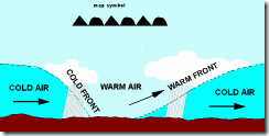
A front is the transition zone (boundary) between air masses of different temperatures and densities. The zone of transition is also called a frontal zone. The type of front depends on which direction the air mass is moving along with the characteristics of the air mass. A frontal zone can be 20 miles wide or it can be over a 100 miles wide.. The frontal zone represents the leading edge of wedge of cool /cold air. if this wedge is moving into a warm air mass it’s called a cold front. but if the colder air retreating and warmer air is taking it’s place, then it’s a warm front.


The types of fronts:

WarmFront

Warm front: is a front that is replacing cooler air at the surface with warmer air. While the passage of a warm front can kick off thunderstorms, normally a warm front is associated with calm and tranquil weather.


ColdFront

Cold front: is a front that is replacing warmer air at the surface with cooler air. typically cold fronts move faster than warm fronts. Normally a cold front is associated with stormily weather 


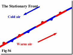
fig56Stationary

This image of a stationary front came from Keithrogershome.com. As the name implies, it’s a front that doesn’t move or moves extremely slow. The winds along the frontal zone are parallel to the front.


occludedfront_aOccluded front, because cold fronts move faster than warm fronts, they overtake the warm front ahead of them.
When cold front catches up to a warm front and lifts the warm front over a dome of very cold air, it’s called a cold occlusion.
When the  air behind a cold front is warmer that the air in front of it (isn't dense enough to lift the warm front ahead of it), The cold front will  climb over the top of the warm front , this  is called a warm  occlusion.


Fronts

On a chart or map, a cold front is represented by a solid blue line, with triangles along it.
A warm front is represented by a solid red line, with semicircles along it.
A stationary front is represented by an alternating red / blue line with semicircles on one side and triangles on the other side.
A Occluded front is represented by a solid line, with the semicircles and triangles on the same side.

Image is from Okfirst.mesonet


The two types of cold fronts:

All cold fronts mean a drop in temperature is on it’s way. However, how much precipitation falls when it passes overhead can vary. Most cold fronts preceded by a shield of rain, However, some of them drop very little. In fact, sometimes the only way you can tell a cold front as passed, is when the temperature  drops and the winds change direction. The names for these two types of cold fronts are called Anafronts and katafronts.

Anafront,  is normally a cold front, that is a heavy precipitation maker. A anafront occurs when a front advances faster that the flow in which it is embedded. Because of this, a cold front in New England can be producing a snowstorm in New York State.

Anafront
The word Ana means to ascend. So in the case of an anafront;  the warm moist air is rising. The warm moist air will rise over the lower edge of the cold front. When this happens it creates clouds and precipitation behind the actual cold front.


Katafront, This type of front is normally associated with little or no precipitation. The Katafront is one where the the flow of the frontal zone is faster than the speed of the front. The flow is also downward. Because the flow is downward it compresses and warms the surface air, which leads to evaporation of the moisture needed to make precipitation.  

Catafront

This results in a long, narrow band of precipitation. Most of the precipitation occurs ahead of a katafront. The warm moist air can’t rise high enough to stir things up, storms have a very difficult time forming.


Isobaric Analysis, you should be able to identify the lines showing the fronts. The other lines are called isobars and depict the areas that have the same corrected sea level barometric pressure.


namussfcwbg
Here is the surface chart for October 9th 2012. You should be able to identify the lines showing the different types of fronts. The other lines are called isobars and depict the areas that have the same corrected sea level barometric pressure. The isobar spacing is at 4 mb intervals, centered on 1000mb. The H’s and L’s indicate areas of high pressure or low pressure.  If the trough of low pressure has a lot of rain or wind associalted with it; the area can sometimes be seen as a thick brown dashed line.


It is my hope that this brief lesson will give you enough knowledge to have an idea what you're looking at on a surface chart.

Rebecca

Wednesday, October 3, 2012

The Weather Channel’s idea of naming Winter Storms gets a cold shoulder


As I posted on my Facebook weather page yesterday, The Weather Channel (TWC) will be naming Winter Storms this upcoming season. Now while the idea might sound good in theory ; the way they implemented it was wrong. Instead of taking the proposal to NOAA or the American Meteorological Society (AMS) , where it could have been looked at and considered. The management at the TWC decided to do it unilaterally. The  lack of coordination between TWC and the rest of the meteorological community, has caused a lot of controversy. TWC give these reasons for rolling out this plan.

1) Naming a storm raises the public’s awareness.

2) Attaching a name makes it easier to follow a weather system’s progress.

3) A storm with a name takes on a personality all it’s own, which adds to Awareness.

4) In today’s social media world, a name makes it much easier to reference in communication.

5) A named storm is easier to remember and refer to in the future.

This all sounds good on paper, some of it might even have merit. However, there have been no studies done, that show the lack of naming Winter Storms leads to less awareness. So I guess we have to take TWC word for it.

I feel this idea is based more on market share and ratings, than it is about rising awareness of major snowstorms. TWC will force the entire meteorological community to bow to the inevitable. In other words, this will cause everyone to adopt the naming system This kind of branding idea is not new, in fact every local station across the country does it . The stations roll out all of their fancy graphics and flashy radar images, in an effort to make you think, they’re the only place to get weather coverage.  So from a marketing standpoint TWC idea of naming storms is a work of genius. Because, if TV stations, the NWS , and even social media sites like mine don’t follow along, there will be confusion on which storm everyone is talking about.  So even if we don’t like the Idea of naming Winter Storms, we will be forced to do so anyway.

As I pointed out yesterday on my weather page; they’ve been naming winter storms in Europe since the 50’s.  The news media has been naming some storms here in the States as well, “Snowmageddon” is just one example. By taking this move, TWC has forced everyone to play along. I don’t feel that the lack of naming Winter Storms has caused a lack of awareness among the general public. But I do have to tip my hat to TWC, you’ve kicked the NWS out of the drivers seat, now you can drive and set the winter weather agenda. I just have this to say to TWC…remember, if a storm doesn’t live up to the hype, your neck is on the proverbial chopping block.


storm-names
Here are the names that TWC will be using for the Winter of 2012 – 2013. These names don’t seem memorable to me, but then that is just my opinion 


Well that all folks, I will be coming out with my final winter of 2012 –13 outlook in a few weeks.

Rebecca