Saturday, October 24, 2015

Hurricane Patricia


In just 30 hours the storm went from a minimal Tropical Storm to a 200mph Hurricane. That alone makes her standout.  Patricia, was very powerful. But was she the most powerful Tropical Cyclone in history ..... no.

Once Patricia reached the 200 mph milestone, it was inevitable that the press, and even many on the weather side of the aisle would start the hype.
 
I'm hearing things like "The most dangerous hurricane in history" ... "Patricia the strongest in history"...."Never been anything like Hurricane Patricia." These statements are not true. The media is using verbal trickery, to make you think something is true, when it's not.


So while Patricia was the most powerful hurricane in the Eastern North Pacific on record (meaning that we know of) She is not the most powerful storm of her type in history.   

The only true way to know the actual strength of a hurricane is by making measurements inside the storm.  This is done with either  weather buoys or by reconnaissance plane. If neither of these are available, you have to use  satellite imagery to estimate the wind speeds and the pressure, which is less accurate.

The vast majority of typhoons (hurricanes) in the Western Pacific, don't get reconnaissance aircraft flying in to get pressure and wind-speed measurements. The typhoons pressure is estimated by satellite. On average West Pacific Typhoons are stronger than their East Pacific or Atlantic Basin hurricane cousins. So I have no doubt that there have been typhoons with lower pressures and higher wind-speeds than Patricia.   

It’s conceivable that other storms in this Eastern Pacific and Atlantic Basin were underestimated. For example, Hurricane Linda in 1997, had no hurricane hunter aircraft fly in. People estimated her pressure at 902 millibars, but that measurement was made with satellite estimates.  Could the 1935 Labor Day Hurricane have been underestimated, absolutely.  Could the same be said for Camille, Maybe.  

The truth is “Patricia is the first hurricane in the western hemisphere a reconnaissance aircraft has measured a wind speed of 200 miles per hour and pressure down to 880.
 
I've also seen reports about the "Enormous size of hurricane Patricia" 


Patricia is a very dangerous hurricane, had a very low pressure center and extremely strong winds, She is one of the most rapidly intensifying tropical cyclones in history.  But the hurricane is small. Sandy largest Atlantic storm in history,  had a  diameter of around 940 miles. Katrina had a diameter of almost 400 miles. Here’s a size comparison I drew in scale.  You can see Patricia is a fairly small hurricane.  And there have be tropical cyclones much smaller than Patricia.


I just wanted to get out ahead of all the hype and misdirection, that is already starting. Major Hurricane Patricia is one for the record books. But as is the case with all tropical cyclones she is unique and her own creature.   


Monday, October 12, 2015

My official winter 2015 2016 outlook.


Well as promised, it's time to take a look at how the upcoming winter will unfold. Remember, an outlook, is not  really a forecast, it's more of a general outlook at how things should unfold. This outlook can't tell you which storms will bring snow/sleet/ or rain. Nor, can it tell you which storms will become major snowstorms.

Last winter, we saw a very cold 2nd half of winter. New England into New York State saw above average snowfall, southern New England saw substantially above average amounts. Well that be the case this winter?

When I do a winter outlook. I look at many variables; since these variables interact with each other, it's not easy doing long range forecasting.  I covered Sea Surface Temperatures (SST) in my preliminary outlook. But I also, look at things like: Siberian snow cover, Sea Ice, and many other variables in the pattern, that I compare  to similar years in the past.  

The Analog Years:

1957 -1958, 2014-2015,1997-1998,2002-2003,1972-1973, 1919-1920, 1982-1983, 1991,1992, 1994-1995,2009-2010.   

The closest analog match with the current El Nino would be 1972- -1973, 1982-1983, and 1997- 1998

But when the other things are factored in. 1957-1958, 1972-1973, and 2014-2015.

OK lets jump into the outlook:

There hasn't been  much change in what I posted in my preliminary outlook.

An El Nino is a major warming in the Eastern Pacific, El Nino Modoki is a major warming in the Central Pacific. The Pacific Decadal Oscillation (PDO) and Atlantic Multidecadal Oscillation (AMO) are measures of SST patterns in the Pacific and Atlantic respectively.    

As I said then, the current El Nino has peaked.  I showed in the preliminary how the SST's had started to cool, off the West Coast of South America. This trend has continued, with the warmest water having shifted away for regions 1 and 2, moving west into region 3.4.  We never saw the Godzilla El Nino, many were expecting. But it did get very strong.

A look at the current El Nino SST setup.

I'm already hearing noise, on how this year's El Nino is going to dominate this winter. But, as I've said repeatedly, El Nino is only one factor out of many, that influence our winter weather in the Northeast and Mid Atlantic. 

PDO:

The Pacific Decadal Oscillation (PDO) ....Those warm SST off the Pacific Northwest and up into the Gulf of Alaska.
 

One of the teleconnections that effect our temperatures is the North Atlantic Oscillation (NAO), when it negative...we can have cold air in the Northeast. The funny thing about last winter, was the fact the NAO was mainly positive. As I said above, last winter was very cold.  The reason for that was the  positive PDO.

Winter of 2014-2015 saw ridging over the West Coast, and a predominate trough over the Great Lakes and East Coast.  This allowed cold Arctic/Siberian air to move off the ridge, down the trough into the East Coast.  The PDO is still strongly positive now.
 

AMO:

The Atlantic Multidecadal Oscillation will be another key player this winter.
 

A lot of people are talking about the so called "Blue Blob" in the North Atlantic near Greenland. They are using words like: "unprecedented", "historic",  and "unusual" when they talk about it. But there is nothing strange about it at all. The Atlantic has been in a positive warm AMO for quite a few years. What we are seeing is the AMO has turned to the cool negative side of the scale. The AMO like all teleconnections goes through warm and cool phases. Here is a chart I made, that shows how the AMO has acted from the past to 2015. You can see the pattern.
The Pacific North American Pattern ( PNA):
When this is in the positive warm phase...we see above average heights over the west and below average heights on the East Coast. Here is a diagram that shows how this works.
 
 
 Snow And Ice Cover:    

Siberian Snow Cover:
 

Snow cover over Siberia is covering a large area, and it is quickly expanding. When I look back at the analog years....The years that saw the most Siberian snow...were quite cold in the Northeast.

The ensembles show the  snow will keep plying up over Siberia and into the Canadian Arctic. This will give that positive PDO lots of cold air to work with. 

Eurasia Snow Cover:


Snow Cover in Eurasia, is a little ahead of last year at this time.

The Arctic sea has stopped its melt, sea ice extent is now increasing. 

Why is snow cover important? A growing snow pack normally leads to higher pressure in the late fall into early winter.  The higher pressures in the mid winter, tends to promote blocking negative NAO and a negative Arctic Oscillation (AO), which sends down cold polar air mid to late winter.

The amount of polar blocking will be a major player, in negating the El Nino. The El Nino winter of 2009-2010 saw a predominate negative AO, that winter saw severe cold and snow in the  Eastern United States, especially the Mid Atlantic.

 I'm seeing a lot of Meteorologist comparing this year's El Nino, to the one in 1997. They are calling for a mild winter for the Great Lakes and Northeast. Why are things like the PDO, AMO, NAO, ENSO and all the others, called teleconnections? The answer is, they are interconnected. They all have an influence on each other.

 I've been saying for months, that this current El Nino was going to fade going into this winter. And that is certainly the case right now.  I've also been saying for months, that the current east based El Nino was going to transition to more of a central based ENSO El Nino (El Nino Modoki)

Here is the current ENSO setup. 


Looking back at 1997 you can see the warm SST all the way to South America.


You can also see the cool SST in the northern Pacific are close to the coast of North America....this would cause a western trough. Also 1997 the Atlantic had cool SST off the East Coast.  All of this is why the winter of 1997-1998 was so warm in the east.

The Australian:


The Australian shows  the El Nino with most of the warmth in the Central Pacific. This setup is in line with my thoughts. This would allow for the trough farther out in the Pacific, which would make for the West Coast ridge  I've been referring to when I talk about the upcoming winter. 

The Jamstek:
 

The Japanese model has been very good this year. The model predicts that the current El Nino most likely has reached its peak, keeping its amplitude until winter. The increasing amplitude of the El Nino Modoki index suggests that the present El Nino most likely will turn to an El Nino Modoki during the winter into spring 2016. This prediction goes along with what I've been saying for the last few months.  


The CVSv2;
 

The American CVSv2 has had issues all year. 30 days ago the model had the ridge even farther east. But as I've said many times the American models have a eastern bias. Now the model has the ridge over Hudson Bay. It's very slowly correcting itself by moving the ridge west..... I expect this trend to continue.

When  we compare the Super El Nino of 1997-1998 and the current strong El Nino. We can easily see the two global SST patterns look very different.

Back in 1997 the El Nino had very warm SST right up the South America...this caused a lot of convection to the north over the West Coast. This lead to a West Coast trough, with an East Coast Ridge. 1997 had a warm north Atlantic, cold SST off the East Coast, cold SST were much closer to the Pacific Northwest. 

For October 2015 we have everything completely opposite, a cold northern Atlantic, warm SST off the East Coast, warm SST in the Gulf of Alaska and off the West Coast... We can also see the Current El Nino has it's warmest SST closer to the central Pacific.
When everything is factored in this is how the models show this winter turning out. 
 

 This is how all the teleconnections correlate. You can see only the El Nino shows a warm winter.


Sunspots:

Solar activity has an impact on winter weather as well. The IPS figures show numbers gradually falling away from the 2011 and 2014 sunspot peak numbers of around 100 monthly. The current numbers show around 50-60 spots monthly. The number of sunspots will keep slowly dwindling until we reach the solar minimum in 2020-2021. So Sunspot activity is very unlikely to be a major key indicator for the winter of 2015-2016.


Wrapping all of this up...

The reason for doing this type of winter outlook analysis, is to provide something against which the upcoming winter can be compared once we get to Spring 2016.  Many meteorologist don't really do analogue-based forecast. Of those who do, my approach differs quite a bit from those I've seen on the web.

I think we're going to see a chilly overall October into first week of November. Then toward middle and end of November we're going to see things warm up into December. The month of December will be quite warm 

Winter is going to be slow to start in the Northeast and Mid Atlantic. But once we get to January. winter will become cold and snowy. February into March will be much the same, The southern Tier of New York State, Southern New England, Northern Pennsylvania will be average to below average in overall temperatures, southern New England down into Pennsylvania will also see above average wintery precipitation.

For the I-95 Corridor, Southern Pennsylvania, and the Mid Atlantic, below average temperatures, with well above average wintertime precipitation.   

Central New York and Central New England will see above average temperatures and below average snowfall.

Far Northern New York, northern Vermont, northern New Hampshire and Maine (especially northern Maine) will see above well average temperatures and well below average snowfall.

For this outlook, I'm going to do things a little different...I'm going to show on the maps, who looks to see what....the numbers and percentages will be based on what is average for those individual areas.  The line A is normal temperatures or snowfall amounts. the farther you move away from A the more your percentage of normal changes. I think this will work a lot better than just saying above or below average.
Temperature:


Precipitation:


The charts should give you a good idea what I expect for your neck of the woods.

The winter of 2015-2016 isn't going to be like the winter of 1997-1998. Also it won't be like the winter of 2014-2015. The upcoming winter will be quite volatile with wild swings in temperatures all the way through January, February, and March.  

Remember I can't tell you how the storms will track. Nor can I tell you if the storms will coincide with the cold outbreaks. 
Thank you, for taking the time to read this outlook.  Next Spring we can discuss how well or how bad my outlook was.


Monday, October 5, 2015

Global warming and hurricanes.


It didn't take long; I'm already seeing articles, linking Major Hurricane Joaquin to global warming and climate change. The latest, is " How Climate Change is intensifying Hurricane Joaquin. By Lydia O'Connor in the Huffington Post. Ms. O'Conner states that "warmer oceans are making everything worse".  O'Conner also quotes Michael Mann, director of the Earth System Science Center, as saying "Joaquin's quickly progressing strength can be tied to unprecedented sea surface temperatures in the hurricanes vicinity."

If you want to read her article you can find it here..

If you've read any of my post on the subject of human caused global warming...then you know I'm a skeptic, of the stinky stuff being peddled by the Climate Science Rapid Response Team. You also know I believe that patterns and cycles are why we see warming or cooling. The same stuff being said about Joaquin have been said of Sandy, Irene and others.  

  I've posted in the blog, many write-ups on hurricanes. A few years ago, I wrote on how we're entering a pattern that we saw in the 1950's. Here are links if you haven't read them.

Part 1  

Part 2

It's common for me to compare current storms to past storms.  Last week I said the overall pattern Joaquin was in was similar to what we saw with Sandy. We had small differences,  like placement of the trough and northern high pressure, that allowed for a different outcome. I also said the East Coast dodged a major bullet, by comparing Joaquin to hurricanes like. Carol Hazel Connie, Diane, and Donna. The idea that what Joaquin did was unparalleled is simply ludicrous.

In the past, the East Coast including the Northeast have seen much bigger hurricane impacts than we've seen in the last several years.

Here is another post I did on historic hurricanes..

The East Coast will see a higher risk for landfalling tropical cyclones, due to the fact that we're  transitioning from a warm positive AMO phase, to a cool negative AMO phase.  The same thing that happened in the 1950's. This was a strong El Nino year, it was (and did) going to cut down on the number of Atlantic hurricanes. But if you read my 2015 tropical outlook...what we saw shouldn't have been a surprise. The reason we saw more of an active season deals with several factors...not the least of which is the AMO.  So while warm Sea Surface Temperatures (SST) are influencing the weather pattern, the reason isn't human caused global warming,

John Abraham, a mechanical engineer from the University of St. Thomas in St. Paul, Minnesota. said in 2012 "Major hurricanes are the only ones that really matter, and that major hurricanes are increasing."

 I guess Mr. Abraham, did not think the records kept by NOAA in the National Hurricane Center data archive, were worth looking at.   NOAA also has "Chronological List Of All Hurricanes Which Affected the Continental United States 1851-2014" These sources show, Abraham and the rest that say "were seeing a greater number of hurricanes and more intense hurricanes" don't know what they're talking about.

Looking into the archive, I was able to compile the following information.

Over the past 100 years 70 major hurricanes have stuck the United States. That makes of a basic average of 7 major hurricanes a decade.

Between 1900 and 1949 there was a total of 91 hurricanes, that made a U.S. landfall, 34 were major.

Between 1950 and 1999 the U.S. was hit by 74 hurricanes, 30 of these were major.

Breaking down the last half century by decade....the data shows.........

From 2001 to 2010 a total of 7 major hurricanes struck the U.S.

From 1991 to 2000, only 6  Category 3 or above hurricanes made a U.S. landfall.....below the 100 year average.

1981-1990, 4 major hurricanes fell on the US, a figure will below the 100 year average.

From 1971 to 1980, the same thing happened, only 4 major hurricanes.

From 1961 to 1970, 7 major hit the U.S.

Over this 50 year timeframe, not one decade saw major hurricane's excide the 100 year average.

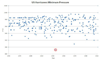
Let's take a look back another 50 years. This is the time, of the 1935 Labor Day Hurricane, this is still the strongest hurricane to make a U.S. landfall....minimum pressure of 892mb, and max winds of 200mph at landfall. It also saw the 1938 Long Island Express, still the benchmark for landfalling Northeast hurricanes...this storm killed over 600 people in just 6 hours. A storm that is almost forgotten is the Great Hurricane of 1941 that carved a deadly damage path from North Carolina to New England. Anyway let's look at the numbers.


From 1951 to 1960, 9 major hurricanes struck the U.S. This decade saw some the worst landfalling hurricanes in U.S. history.   

From 1941-1950,  an incredible 11 major hurricanes made a U.S. landfall. That is well above the 100 year average.

From 1931-1941, 8 major hurricanes struck the United States.

From 1921 to 1930, 6 major U.S. falling major hurricanes.

From 1911 to 1920, 8 major hurricanes struck the U.S.

If we were to look back even further, we would find the Great Galveston Hurricane.    

It's clear that the first half of the 20th Century was worse than the second half.

One more thing, I want to touch on. There hasn't been a major hurricane making a direct hit on the United States in nearly 10 years. There have been 9 major landfalls in the Caribbean and South America, but not one on the U.S.

2005 was the most active year in the Atlantic since records have been kept. 2005 saw the likes of Katrina,  Rita, and Wilma, the last major hurricane to strike the U.S....on October 24th, 2005.

Why the major hurricane drought?  Well since 2005, there haven't been many hurricanes that formed close to the U.S. Another reason is the weather patterns have discouraged land falling tropical systems. In 2005 we had a high pressure ridge over the East Coast.  But since then many years have seen a trough of low pressure sitting over the East Coast, So as was the case with Joaquin, major hurricanes have just gone out to sea.

Joaquin was going too slow to get steered into the East Coast, if he had, the damage would have made Sandy, seem like a thunderstorm in comparison. The major cites on the East Coast are very vulnerable to major hurricanes. The major cities and most of the communities along the East Coast have seen incredible growth, much of this growth has occurred right at the coast.

I've just shown you the facts. In spite what the global warming alarmist what you to believe, the record speaks for itself. There has been no noticeable increase in either the number of or intensity of hurricanes over the last 100 years.   


If you want to look at the numbers..... NHC Data Archive    


Sunday, September 13, 2015

Hot...Hot....Hot.


The first half of September has been hot. After this little mid month cool down, temperatures will head back to above average.

I've noticed the main stream media and several in the climate science community, have thrown how hot September has been. Once again the Global Warming Crowd (GWC) is throwing out terms like record breaking,  unprecedented, and historic to describe the current late season summer. I didn't hear any of them talking about our cool July and August. I guess they didn't notice.

As most of you know, I'm not a believer  in the idea of humankind's greenhouse gas emissions are behind this idea of global warming. I've stated many times I believe patterns and cycles are why the weather on earth behaves like it does.  

Here is a blog post I did a few years ago on the subject. You can find it here.

My outlook for winter 2014-2015 was right on the money.  If you remember, I stated back in March, how the spring and much of summer would be cool in the Northeast. That was certainly the case. I forecasted that September would start well above average, cool down, and then warm right back up again.... over a month and a half ago. Again, that is what we are seeing. I've stated the current El Nino would weaken and become central based, as we got closer to winter into the first half of winter. The model are now showing my idea looks likely.

I posted my preliminary winter 2015-2016 outlook weeks ago. The warm September and the trend of the El Nino go hand in hand with the winter pattern outcome I outlined.

None of this is done with magic..... I've used pattern recognition.

I'm sure others see the same things I'm seeing.....but it seems that those who think everything we're seeing today is something brand new....get all the coverage.

I'm not saying I have all the answers....but I've just outlined a few examples of doing long range forecasting....and have it come to pass. I've been wrong sometimes, but I've been right much more than wrong.

Yes this September has been hot. But it is hardly record breaking.

Here is a chart showing how this September stacks up to past years in Central Park. 


Boston, Hartford, and Providence have seen warmer Septembers.

Boston's September record is 102 back in 1881. Hartford set a September temperature record of 101 back in 1953.  Providence set its record high of 101, back in the last September Northeast heat wave in 1983.

The Mid Atlantic has had a long stretch of 90+ days. But back in 1953 records show there was a September heat wave of 100+ for five consecutive days.  That was set at the old weather bureau office in Washington DC. The records taken at the old weather bureau most of the time aren't included in the official records used today.

This is only a small sampling of the records I looked at. If you want to research, you can find a lot of data at KNMI Climate Explorer.

Despite what the main stream media and human-made global warming groups want us to believe, all the evidence shows, the vast majority of the record highs were set at least 50 years ago. 

This shows the 1890's and 1930's were very hot decades. This was before large increase in CO2 levels.


Given the fact of the amount of urbanization and incredible growth of CO2 levels since 1960.  The lack of heat records does seem odd, if you believe in manmade global warming.

Per NOAA, 82% of all maximum records were initially set prior to 1960 and prior to the accelerated growth of human CO2 emissions and atmospheric CO2 levels.

The records show, through 2011, no maximum temperature records have been set since the 1990's. This is simply astounding since all the climate doomsday pundits have stated that recent global warming was "unprecedented" and that U.S. temperatures were rapidly increasing due to CO2 levels.

Based on the hysterical hype-ridden talk from mainstream media sources, one would naturally have expected to see new maximum temperature records set in recent years.


Sea Surface Temperatures (SST)

This year, we have a very strong El Nino going on. In the northern hemisphere, Global SST temperatures have risen +0.042 deg C over July, June and August. The global SST have decreased in the southern hemisphere.

An interesting side note.....during the 1997 Super El Nino, no temperature records were broken in the U.S. If you think greenhouse gasses cause global warming...you would have expected to see thousands of record highs....instead there were none....anyway back to SST's

As was the case last year the north Pacific has seen the most warming. Many have nicknamed this area the "Blob"  The blob started in 2012. Before that there was no warming on whole for decades and decades.

Note all of these charts were put together by Bob Tisdale

Here is the SST anomaly chart for the north Pacific. The chart covers the satellite era from 1981 to 2014.


According to NOAA   the north Pacific covers about 21% of surface area for global oceans...(an area bigger than Asia, Europe, and North America). starting from 2013 you can see the unusual spike in SST. prior to 2013 there had been no warming for almost two and half decades. The NOAA link is here.


What is amazing is that during those two and a half decades of no warming...greenhouse gasses were running amok......It doesn't take a rocket scientist to see something not involving greenhouse gasses is going on.


shows no real warming.....


when you add 2013 and 2014 you see a spike. A spike that looks like a very strong El Nino......what....don't we have a strong El Nino going on?  Why Yes We Do...could that be a coincidence? I think not.


Here is one more chart...it shows what the climate models say should be happening verses what the actual data shows.


You can see the models used by climate scientists doubles the SST from that is actually occurring. Clearly the data being input is faulty. This just shows how unreliable climate models truly are.


In conclusion, I've shown how this September warmth is not at record levels nor all that unusual. I've also shown how greenhouse gas emotions can't be the cause of global warming nor ocean warming.

The things that drive climate and weather on the planet Earth are the Sun and the Oceans. El Nino and La Nina are a major factor in warming and cooling across the northern hemisphere. Oceans are behind the rise in temperatures...look how much just the north Pacific has impacted SST and air temperatures.          

Thursday, September 3, 2015

Winter 2015 2016 preliminary outlook


Here is a look at my preliminary winter 2015-2016 outlook, My final outlook will be posted in 4 to 6 weeks.

This will be based on Sea Surface Temperatures (SST). The final one will include SST but it will have other factors involved as well.

The last few years I've released my preliminary thoughts for the upcoming winter around this time.  But this year, I've tried something new; I also posted how things looked to be shaping up over the Summer and how those would impact the coming winter.

Before I start talking about the winter...I want to look at how the summer turned out.
Temperature wise the northeast saw a slightly below average to average Summer.  The precipitation pattern has been active, but still ended up being below average.

Here are a few charts I made up to show how the current setup matches what we've seen this summer. 
  
Above is taking the analog years and put them into a chart. The chart shows the average temperature pattern we should have see this summer.


Above is shows how the last 90 days shaped up in the temperature department. You can see that it matches up well to what the analog years said should happen.

If you've followed my Facebook weather pages...you know I've been saying for about two months, that September would start out warm, then cool off around mid month, then heat back up for the end of September into the first part of October. Here are a few charts that show the models agreeing with my thoughts. 

 Above shows the cool down for mid month..


Above is showing how we warm up to above average temperatures for the last half of September into the first part of October.... After that I do think we will see things cool off a bit for the rest of October into November....before we warm up again for December.


The above images show how the precipitation has shaped up so far this Summer.

The reason I've showed the last 90 days, is to give you confidence that this analog approach to doing long range forecasting is a very good tool.

Ok what about the upcoming winter?:

My Analog years:

1919-1920, 1957-1958, 1972-1973, 1982-1983, 1991-1992, 2009-2010, and last winter 2014-2015.

ENSO El Nino:

As most of you know, we have a strong El Nino right now.

An El Nino winter tends to be milder, than a weak El Nino or a La Nina. But Like I've posted before, the PDO, AMO, AO, and the NAO also have a lot of influence on our climate up here in the Northeast. Below I will post images of our current El Nino and how our current pattern compares to winter 2014 - 2015.

But first, I've been saying for the entire summer, that the current El Nino was going to shift west later this fall into the winter. This is now starting to happen. Here is the Current El Nino, I've also place a chart showing the El Nino regions.


Here is what the El Nino looked like last month.


And here is July


You can see the SST off the West Coast of South America are cooler than they were a month ago. The warmer water is a little farther west.


Here is last years SST setup.


I've marked five areas that have a major influence on our temperature patterns.  The sea temperatures in these areas are the reason last winter was so cold.

1) Warm SST in the Gulf of Alaska. This correlates to a ridge out west and a trough over the East.  

2) Warm SST off the West Coast and the Baja. This also correlates to cold in the Northeast.

3) When we see cooler SST's northwest of Hawaii, we often have colder air in the Northeast and Mid Atlantic.

4)  A weak El Nino Modoki also means it's typically cold on the East Coast.

5) Cold SST's in the North Atlantic around Greenland, is a good sign for cold in Eastern Canada and the Eastern U.S.

Here is the current setup.  I've marked the same five areas.


You can see area 1 has extended farther west.

Area 2 is much warmer and also has extended west.

Area 3 is still cold but the warmth to the east has eroded it's over all size a little.

Area 5 is still cold.

The biggest change is area 4.

The warm El Nino will have an impact on our winter of 2015-2016.

A cool La Nina or a weak central based Modoki is typically a cool sign in the Northeast. Last winter we had a neutral ENSO or a weak Modoki El Nino. This effected the Jet Stream. it helped setup the ridge out west and the persistent trough over the East. It also allowed the southern sub tropical jet to move further north....which helped the northern and southern jets to phase.  This is why New England saw all the snow.

The warm El Nino is going to effect our fall into winter. As I said the current El Nino is starting to shift west. I do expect this to continue into the first part of winter, I also expect the El Nino to be weakening late fall into winter. . The question is how far west and will the El Nino weaken?


Pacific Decadal Oscillation (PDO):

The PDO involves the warm SST in the Gulf of Alaska and Pacific Northwest.  Here is a chart that shows the typical impact of the PDO warm and cool phases. 


Here is how the years with a strong El Nino, stacked up to the years that had a weak El Nino.
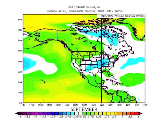


1997-1998 was a super El Nino.  The winter of 1997 - 1998 was extremely warm in the Northeast. But 2015 -2016 has a different set up.....


The big differences are the warm waters around Greenland, the warm waters northwest of Hawaii. and the PDO had a much weaker warm phase.

So while the strong El Nino is hinting at a warm winter, the PDO is saying the exact opposite.  The El Nino will have a big impact, but of the two, the PDO will have a bigger impact.

 As we head into fall.  I've already shown how September looks to be warm.  I think we will see things cool off a little for October and November. But we will warm back up for December.

Using the current factors here is how December looks to be


When I factored in the Analog years......here is how things look to unfold this winter January into March.....


February is looking to be very cold.


Here is how the precipitation outlook looks to unfold....if things trend the way I think they well.


So right now this is how it looks to be this winter.

Heading into winter October and November will seasonally cool. Then we will see a big warm up for December.

Winter will start out mild. But then things look to get cold for January, February, and the first part of March.

Temperatures look to be below average for the southern tier of New York State (south of the Mohawk Valley), Southern New England, Pennsylvania, and the Mid Atlantic. With Northern New York and the Rest of New England seeing average to slightly below average temperatures. 

The indications are that around the Great Lakes through Southern Pennsylvania and into the Mid Atlantic would see lots of snow.... amounts of  40% to 50% above average are looking possible. Northern Pennsylvania and New York State south of the Adirondacks would see average to 25% above average....Northern New York and northern New England look to be around average........

Here are some rough maps showing what I've just said.

Snowfall outlook


Precipitation outlook


Well that's about it.  What I've shown here is now things look at this time... I will modify all of this when I issue my final outlook sometime in October.