
Hi, it's Rebecca again, as most of us are sadly aware parts of the Midwest and Southeast were savaged by a large severe outbreak last week. Even though the total number of tornadoes won't be known for a few days yet, with over 80 confirmed tornadoes , it's safe to say that the March 2nd-3rd outbreak will be the largest early season outbreak in history. The Ohio Valley, Indiana, and northern Kentucky regions were hit the hardest. However, the tornado outbreak spanned 11 states, with non tornadic damage in four other states including New York State. As of this writing the death count is at 40, If you include the Leap Day tornado outbreak (February 28 and 29, 2012) that killed 13 people across the Mid-West in the states of Missouri, Kansas, and Nebraska 53 people have died in these two outbreaks. The tornadoes on March 2nd and 3rd left incredible destruction in their wake; that will cost billions to rebuild. Even though I had seen the setup and knew it was going to be a bad outbreak, I was in awe of what I was seeing. So far, the worst tornado of the outbreak was the EF4 that struck Henryville and Marysville, where those towns were virtually wiped off the face of the earth.
I've been talking about the outbreak on my Facebook weather page. But I wanted to post a blog entry on it that would go into more detail on the setup and breakdown the outbreak as things were occurring; as well as do a little comparison to the Super Outbreak of 1974.
The Setup:
Fig 1


A strengthening low pressure system was pushing toward Missouri, by the morning of the March 2nd The low had a cold front this front extended southwest into Texas. Behind the cold fronts lots of cold air was surging forward. There was one other front that would play a huge role in the upcoming outbreak. The system that produced the tornadic outbreak on Feb 29 had stalled in the south, this stalled front became a warm front on the March 1st, as the warm front advanced toward the Ohio Valley. it just added fuel to the fire by reinforcing the unstable air mass.

Showing the area of high risk on March 2nd 2012
The reason Central Kentucky to Middle Tennessee would be the area for maximum tornado potential was based on several factors. For one, there was a 130 knot jet; the fastest upper-level winds will be centered right over this area during the afternoon. When you couple that with almost southerly winds (maybe a bit southwesterly at times), you get not only a high difference between wind speed aloft and at the surface, but also a difference in direction. This is called wind shear and it's crucial to sustaining a thunderstorm and allowing it to become strong enough for tornado development. The southerly winds at the surface will help what's called low-level wind shear, and that's usually a pretty big factor in who gets tornadoes. Also, Temperatures were in the 60's, in fact widespread temperatures of mid to upper 70s were reported from the Gulf Coast to Tennessee and Kentucky. The Nashville International airport had a record high of 81; these temps were 11 to 20 degrees above normal for March 2.

SKEW-T sounding for March 2nd 2012
As you can see the setup was near textbook for a major outbreak. Everything was pointing to an especially dangerous situation with strong, violent, and long lived tornadoes. Throw in they would be fast moving, rain wrapped, and many occurring during the night and you had a disaster in the making. I will now show a brief timeline on how the outbreak unfolded.
A brief timeline:
Fig 1

Surface map for March 2nd 2012
Fig 2

The graphic on the left shows the SPC Convective Outlook for March 2nd, with the Moderate Risk area outlined in red, the Slight Risk area outlined in yellow, the area where general thunderstorm development is expected outlined in green. The image to the right, produced by the NOAA Visualization Lab, shows thunderstorm probability from the NAM 00Z
A strengthening low pressure system was pushing toward Missouri, by the morning of the March 2nd The low had a cold front this front extended southwest into Texas. Behind the cold fronts lots of cold air was surging forward. There was one other front that would play a huge role in the upcoming outbreak. The system that produced the tornadic outbreak on Feb 29 had stalled in the south, this stalled front became a warm front on the March 1st, as the warm front advanced toward the Ohio Valley. it just added fuel to the fire by reinforcing the unstable air mass.
Based on the parameters the Storm Prediction Center (SPC) was seeing on March 1st; the SPC outlined an area from Southern Ohio and points south to the northern parts of the Gulf States as a moderate risk area for severe weather for the next day (see fig 1and 2 above). This included a 15% tornado risk. It didn't take long for things to start, storms started breaking out over Southwest Missouri at 200am CST, NWS issued a severe thunderstorm warnings for hail and strong damaging winds. Before 8:00 am CST the low pressure system was deepening over southern Missouri and was heading toward Illinois. The location of the low would be crucial on what would occur later in the day; the movement of the low allowed southerly winds to pull a lot of warm moist air from the Gulf of Mexico (which was warmer than normal, warm and humid air is a key component to severe thunderstorm and tornado formation), out ahead of the trailing cold front. With dewpoints rising into the 60′s to near 70 in some spots and high levels of Convective Available Potential Energy (CAPE) (see note A). At 8:00 am CAPE values where already at 1500 J/Kg. with MLCape values forecasted to be over 2000 J/kg, with MLCape values above 3000 J/kg over parts Kentucky and Tennessee. (Significant tornadoes are most often associated with MLCAPE greater than 1000 J/kg.). Based on how things were developing, the SPC issued a high risk for tornadoes for Southern Indiana, Central Kentucky, and North Central Tennessee (see fig 3).
Fig 3

The 12Z soundings showed severe weather indexes on March 2nd that were mind-blowing. The shear profile was nearly perfect, veering wind from SSW at 15kts at the surface to WSW at 70kts at 500mb. Along with the high CAPE values, LFC (Level of Free Convection) (see note B) and LCL (Lifted Condensation Level) (see note C) showed a Significant Tornado Additionally, the LI (Lifted Index) (see note D) was at a -6 for the 12Z sounding. Usually anything below an LI of -2 can potentially produce severe weather with isolated tornadoes. However, a -6 is very impressive and indicates a large amount of instability in the atmosphere. (fig 4) is a sounding that shows this data. I will include a link to a blog post that explains how to read a SKEW-T sounding at the end of this post.
Fig 4
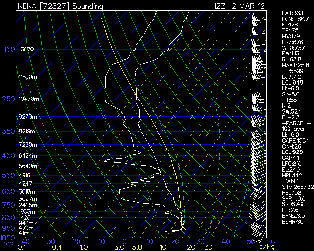
SKEW-T sounding for March 2nd 2012
As you can see the setup was near textbook for a major outbreak. Everything was pointing to an especially dangerous situation with strong, violent, and long lived tornadoes. Throw in they would be fast moving, rain wrapped, and many occurring during the night and you had a disaster in the making. I will now show a brief timeline on how the outbreak unfolded.
Friday morning,
As I said earlier, there was a strong low that was rapidly intensifying. A cold front stretched southwest from the low into northern Texas. The warm and moist air was surging north ahead of the low from the central Gulf Coast into the Tennessee and Ohio Valleys. The upper atmosphere featured huge instability. By 9:10 am, the first tornado of the day developed near Madison and Limestone counties in north Alabama. This tornado was later rated an EF3; with a path length of 34.4 miles and a width of 250 yards. This tornado had peak winds of 140 mph and caused considerable damage in many areas. During the rest of the morning several more tornadoes, many of them long track, were tearing up the landscape.
As the warm front pushed north, The SPC issued several tornado warnings. However, the major threat was the strengthening low to the west. With the deepening low with the cold front dragging in the cold air, and the northward moving warm front increasing the instability out ahead of the low. It was easy to see that the clash of warm and cold air masses would produce violent, long-track tornadoes over Indiana, Kentucky, Ohio, and Tennessee.
By the early afternoon,
The low-pressure system was stronger and centered over east-central Illinois with a cold front extending south from the low across southeast Missouri to central Arkansas and east Texas. At 12:37 PM CST a tornado was on the ground in Posey County, Indiana. By this time Many Tornadoes were on the ground in several states. One of the hardest hit areas on March 2, 2012 was Henryville, Indiana. In the early afternoon a series of supercells developed in southeast Indiana. This line was moving northwest at speeds of over 60 mph. the first supercell in the line produced the first tornado at 2:50 pm CST. This tornado soon became the strongest tornado of the day. The EF4 hit the small towns of Henryville, Marysville, Chelsea, along with several others. The tornado smashed into Henryville and Marysville with devastating force, that the tornado all but wiped the towns off the map. The Henryville tornado had max winds of 175 mph, path length of 49 miles, it obtained a width of one-third to one-half mile. Below is a fig 5 that shows the track the tornado took. At its peek the tornado had max winds of 175 mph. In fig 5 you can see the track this tornado took. Fig 6 will show the path the EF4 took though Henryville.
Fig 5

Image of the track the southern Indiana EF4 took. As you can see it just missed the compact city of Louisville Kentucky. If it had been just a bit more to the south the amount of destruction and number of deaths would have been almost incalculable.
Fig 6

Picture shows the path the tornado took through Henryville.
Early evening,
The radar showed Dozens of severe thunderstorms along the cold front and individual thunderstorms ahead of the main line. There were severe tornadoes with this line. At approximately 5:51 PM EST a tornado was spotted on the ground; by 5:58 pm the tornado was moving into the center of West Liberty. In a few minutes frantic calls started pouring out of the town. The reports said significant damage was occurring in the downtown area of West Liberty, along with law enforcement reporting that people were trapped in buildings. This tornado was later rated as an EF3.
Dr. Jeff Masters at Wunderground.com reported the West Liberty tornado “The tornado carved a 60-mile-long path through Eastern Kentucky, causing extreme damage in West Liberty. The tornado killed six in West Liberty and two near Frenchburg. At least 75 people were injured. It was the first EF-3 tornado in Eastern Kentucky since 1988.”
After Dr. Masters made this quote, the track of the West Liberty tornado was found to be 95 miles long (see fig 14)
Fig 7

Radar Velocity scan of the West Liberty EF3After Dr. Masters made this quote, the track of the West Liberty tornado was found to be 95 miles long (see fig 14)
Fig 7

The March 2-3 2012 outbreak looks to be the largest 2-day tornado outbreak for so early in the year. As of March 6th SPC has 121 tornado preliminary reports. The SPC also has preliminary reports that show 11 tornadoes reported in Georgia and Florida, it also looks like 3 tornadoes occurred on March the 1st. Normally you can weed about 15% of the preliminary reports out.Also, there still could be a few more tornadoes discovered, Which would bring the total number of tornadoes for the March 2-3, 2012 outbreak in the range of 100-110. To give you and idea of just how sufficient that number of tornadoes is for this early in the season. The 10-year average U.S. tornado count for the entire month of March is only 87 tornadoes! The record for any entire month of March is 180 tornadoes set in 1976.
A comparison to other Outbreaks:
NWS forecasters could tell something bad was brewing over the central United States. On April 2, 1974, A huge low pressure system with a lot of cold dry are was dropping out of Canada. On the other side of the coin, there was a huge surge of warm moist air being pushed northward, toward the Mississippi, Tennessee, and Ohio River Valleys. This huge clash of air masses was going to collide under a fast moving jet moving at 122 knots. during the overnight on April 3rd upper level winds had greatly increased over Alabama, Louisiana and Mississippi as the low pressure system continued to deepen. On the morning of April 3rd, an area of low pressure was located in central Kansas. A warm front extended east-northeastward through the lower Ohio River Valley. South of this front, extremely unstable air had gathered during the overnight hours and was rapidly spreading north. CAPE by 7:00 am was already over 1000J/kg and dewpoint were rising quickly. In the early afternoon of the 3rd all hell broke loose. When the outbreak was over, the storm system had spun-up 148 tornadoes across 13 states, when the damage was surveyed it was discovered that 30 tornadoes were F4 and 6 were F5. The super outbreak of 1974 caused unbelievable destruction and killed 315 people.
If I changed the date on these parameters; they could easily be substituted for the morning of March 2nd 2012. In fact if you look at the surface charts (Figures 8 and 9) you can see the charts look virtually identical. The two outbreaks had several similarities, both had fast upper level winds, cold air moving east that would slam into the advancing warm moist air out of the Gulf, at just the right time to produce explosive supercells. Also both of the outbreaks had snow on the backside.
Fig 8

Surface map at 8 am on April 3rd 1974
Fig 9

Surface map at 7 am on March 2nd 2012
Fig 10

Showing the tracks of the tornadoes in the 1974 Super Outbreak
Fig 11

Fig 12

Fig 13

Fig 14

Shows the 95 mile track of the West Liberty tornado
Figure 10 shows the tracks of the 148 tornadoes on April 3rd 1974. Figure 13 compares the NWS warnings for the April, 2011 and March, 2012 outbreaks. If you compare fig 10 to figures 11 and 12 you will see that April 3rd, 1974, April 28, 2011, and March 2nd, 2012, all had huge numbers of tornadoes. With tracks that could almost go on top of each other. All three outbreaks had a fast upper level jet moving at 100-130 knots. with strong low pressure systems and other severe parameters, that could have almost been mirror images of each other.
Notes:
Note A: CAPE stands for Convective Available Potential Energy, it's a measure of the buoyancy of a layer of the atmosphere. The larger the CAPE the Greater the potential speed of the updraft. Generally the larger the CAPE the taller and stronger the Thunderstorm.
CAPE Values:
0001-10000 J/Kg Marginally Unstable
1000- 2500 J/Kg Moderately Unstable
2500-3500 J/Kg Very Unstable
3500 J/Kg and higher Extremely Unstable.
Note B: The level at which a parcel of air lifted dry and adiabatically until saturated, and lifted adiabatically thereafter, would first become warmer than its surroundings in a conditionally unstable atmosphere.
Note C: Lifting condensation level(LCL) can be said to be the level to which an unsaturated air parcel can be lifted adiabatically before it becomes saturated. Remember, this unsaturated air parcel is moist.
Note D: Lifted Index (LI) is another way to measure atmospheric instability. Negative values indicate instability. the more negative the number, the more unstable the atmosphere is.
Additional links for more information.
A blog post on how to read a SKEW-T sounding
A blog post that goes into how a tornado forms.
Link to a website that has several videos of the March 2nd-3rd outbreak
Dr Jeff Masters blog.
Interactive map of damage reports for the March outbreak
Well that's it for this blog installment. I hope you found it informative and interesting. As always, I welcome feedback and questions....until next time.
Rebecca
No comments:
Post a Comment
Thank you for taking the time to comment, I will answer as soon as I can.