
Honorary mention, Virga
Virga is when ice crystals in clouds fall, but evaporate before hitting the ground. They appear as trails from clouds reaching for the surface, sometimes giving the cloud a jellyfish-like appearance.

Image credit Marialuisa Wittlin
20) Mammatus Clouds
These clouds often accompany severe thunderstorms, but do not produce severe weather; they may also accompany non-severe storms as well. Even though they look scary they're not. Their presence doesn't mean a tornado is ready to form. In fact, these clouds are usually seen after the worst of a thunderstorm has passed. Mammatus clouds are formed when an updraft carries precipitation enriched air to the top of a cloud, the upward momentum is lost and the air begins to spread out horizontally, becoming a part of the anvil cloud in the thunderstorm. Due to its high concentration of precipitation particles (ice crystals and water droplets), the saturated air is heavier than the surrounding air and sinks back toward the earth. The subsiding air eventually appears below the cloud base as rounded pouch-like structures.

19) Roll Clouds
A personal favorite of mine, roll cloud are often confused with shelf clouds. Shelf clouds are attached to the parent cloud, whereas the roll cloud is not. Roll clouds can be hundreds of kilometers long, and, just as the name suggests, they roll. This is because of cold air rushing out of a downdraft from a storm front, lifting warm air which cools and sometimes forms this type of cloud. If you want to get an idea of what this actually looks like in motion then the video above shows a brilliant demonstration of this, so watch and be in awe.
A personal favorite of mine, roll cloud are often confused with shelf clouds. Shelf clouds are attached to the parent cloud, whereas the roll cloud is not. Roll clouds can be hundreds of kilometers long, and, just as the name suggests, they roll. This is because of cold air rushing out of a downdraft from a storm front, lifting warm air which cools and sometimes forms this type of cloud. If you want to get an idea of what this actually looks like in motion then the video above shows a brilliant demonstration of this, so watch and be in awe.

Happens very briefly just before sunset and just after sunrise. Green flashes are not always green; they can be yellow, blue, or even violet. However, green is the hue seen most often. It usually lasts only a few seconds at moderate latitudes. The main cause for a green flash is the refraction of the shorter wavelengths of light in the atmosphere (atmospheric dispersion). The other reason is that the retina red-sensitive photo pigment becomes oversaturated the bright red color of the Sun, which can lead to a change in color perception.


Image credit P Braun
17) Sun Pillars
Sun Pillars are vertical pillars of light above and sometimes below the sun. They occur when the light of the setting or rising Sun reflects off high, icy clouds at different layers. It is also possible to see moon pillars.

Image credit lucycat
16) Mirage
This is another thing cause by the refraction of light. Most of the time objects look to disappears when something enters the mirage.

15) Colored Moons
Colored Moons are caused by such things as : excess smoke from forest fires, volcanic eruptions, , dust (during the 1930's the dust bowl era saw colored moon very often), and eclipses can cause the moon to change color.

14) Moonbows
A rainbow is caused by the Sun shining on moisture droplets, most commonly in a post-rain atmosphere. A moon bow is much rarer only seen when the moon is low and full to almost full. Moonbows are created the same way as rainbows; the moon light hits water droplets and refracts in its component spectrum of different colors.

13) Fogbows
Fogbows are also called: Seadogs, White Rainbows, and Cloudbows. They are formed the same way a normal rainbow does, by the diffraction of light through water droplets. However in the case of a fogbow the effect is caused by very tiny droplets. Because the light is passing through tiny fog droplets, which cause more diffraction.

Image credit Ken Ichi
12) Anticrepuscular Rays
Formed at sunrise or at sunset. These appear to emanate not from the sun, but from the point on the horizon directly opposite it. The effect is caused by sunlight being sent through some well placed clouds.
12) Anticrepuscular Rays
Formed at sunrise or at sunset. These appear to emanate not from the sun, but from the point on the horizon directly opposite it. The effect is caused by sunlight being sent through some well placed clouds.

Image credit Nate Cassell
11) Lenticular Clouds
These unusual clouds are a lens-like shape, tend to form at high altitudes, normally aligned perpendicular to the wind direction. Lenticular clouds can be separated into altocumulus standing lenticularis (ACSL), stratocumulus standing lenticular (SCSL), and cirrocumulus standing lenticular (CCSL). Some people call them Unidentified Flying Object (UFO) clouds. They may not be UFO's, but they will make you take a second look. These clouds can be shaped like a stack of lenses, a single large lens , or even just a particularly long cloud. This type of cloud forms where stable moist air flows over a mountain or a range of mountains, a series of large-scale standing waves may form on the downwind side. Lenticular clouds sometimes form at the crests of these waves. Under certain conditions, long strings of lenticular clouds can form, creating a formation known as a wave cloud.

Image credit C. Moses
10) Fire Rainbow
The rainbows are caused by ice crystals in the thin, distant clouds being at just the correct angle to refract the sunlight into the colors of the prism.. Fire rainbows are rare sights in the mid-latitudes, because they can only occur when the sun is 58 degrees or higher above the horizon. For the United States in general that pretty much relegates any sightings to roughly around 6 weeks either side of the summer solstice

Image credit Schristia

9) Noctilucent Clouds
These are high atmosphere cloud formations thought to be composed of small ice-coated particles; their precise nature remains a mystery. They form at very high altitudes - around 82 km above sea level - and are, thus, a quite separate phenomenon from normal weather. They are only visible against a twilit sky background when the clouds occupy a sunlit portion of the Earth’s atmosphere that refract light at dusk when the Sun has already set, illuminating the sky with no seeming light source.
These are high atmosphere cloud formations thought to be composed of small ice-coated particles; their precise nature remains a mystery. They form at very high altitudes - around 82 km above sea level - and are, thus, a quite separate phenomenon from normal weather. They are only visible against a twilit sky background when the clouds occupy a sunlit portion of the Earth’s atmosphere that refract light at dusk when the Sun has already set, illuminating the sky with no seeming light source.

Image credit Nige B
8) Gravity Wave Clouds
The reason these clouds are described as waves is because they look like waves in general, but they look like waves especially in motion . The way these clouds are formed is by a trigger mechanism must cause the air to be displaced in the vertical. Examples of trigger mechanisms that produce gravity waves are mountains, frontal systems, and thunderstorm updrafts, which creates this momentum in the clouds.

7) Kelvin Helmholtz cloud formations
These clouds are also known as billow clouds, shear-gravity clouds, KHI clouds, or Kelvin-Helmholtz billows. The rolling eddies seen at the top of the cloud layers are usually evenly spaced and easily identifiable. When two different layers of air are moving at different speeds in the atmosphere, a wave structure will often form. The upper layers of air are moving at higher speeds, these shearing winds will often scoop the top of the cloud layer into these wave-like rolling structures. The clouds often form on windy days where there is a difference in densities of the air, such as in a temperature inversion. If you ever see them grab your camera quickly, they don’t retain this shape for very long, and they don’t occur very often either.
These clouds are also known as billow clouds, shear-gravity clouds, KHI clouds, or Kelvin-Helmholtz billows. The rolling eddies seen at the top of the cloud layers are usually evenly spaced and easily identifiable. When two different layers of air are moving at different speeds in the atmosphere, a wave structure will often form. The upper layers of air are moving at higher speeds, these shearing winds will often scoop the top of the cloud layer into these wave-like rolling structures. The clouds often form on windy days where there is a difference in densities of the air, such as in a temperature inversion. If you ever see them grab your camera quickly, they don’t retain this shape for very long, and they don’t occur very often either.
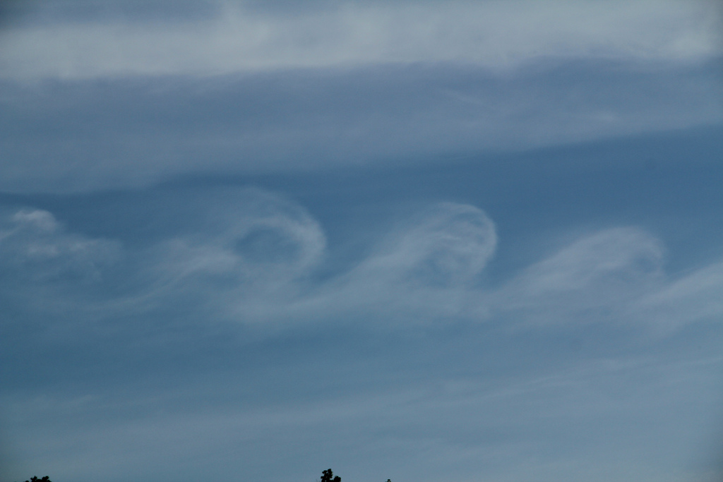
Image credit Matt Lanza6) Katabatic Winds
These are also called down-slope winds, gravity winds, in southern California they are called Santa Ana. They are formed when wind blows down a slope. These winds carry dense air from a higher elevation to a lower elevation because of gravity. It occurs at night, when the higher elevations radiate heat and are cooled, air in the higher elevation is also cooled, and it becomes denser than the air at the same elevation, it therefore begins to flow downhill. This process is most pronounced in calm air because winds mix the air and prevent cold pockets from forming.
These are also called down-slope winds, gravity winds, in southern California they are called Santa Ana. They are formed when wind blows down a slope. These winds carry dense air from a higher elevation to a lower elevation because of gravity. It occurs at night, when the higher elevations radiate heat and are cooled, air in the higher elevation is also cooled, and it becomes denser than the air at the same elevation, it therefore begins to flow downhill. This process is most pronounced in calm air because winds mix the air and prevent cold pockets from forming.

Image credit vectorchem
5) St Elmo’s Fire
This weather phenomenon involves a gap in electrical charge. It's like lightning, but not quite. Lightening is the movement of electricity from a charged cloud to the ground, or another cloud. Whereas St. Elmo's Fire is more or less just a spark, It appears like fire on objects, such as the masts of ships, lightning rods, or church steeples. It occurs most often on pointed objects because the tapered surface will discharge at a lower voltage level. St. Elmo's Fire is exactly what's happening in neon tubes -- essentially a continuous spark. A neon tube is simply St. Elmo's Fire contained in glass. This occurrence was named the after St Elmo, the patron saint of sailors.
This weather phenomenon involves a gap in electrical charge. It's like lightning, but not quite. Lightening is the movement of electricity from a charged cloud to the ground, or another cloud. Whereas St. Elmo's Fire is more or less just a spark, It appears like fire on objects, such as the masts of ships, lightning rods, or church steeples. It occurs most often on pointed objects because the tapered surface will discharge at a lower voltage level. St. Elmo's Fire is exactly what's happening in neon tubes -- essentially a continuous spark. A neon tube is simply St. Elmo's Fire contained in glass. This occurrence was named the after St Elmo, the patron saint of sailors.

Image credit Pawel Forczek
4) Sprites, Jets, and Elves
All refer to phenomena that occur in the upper atmosphere in the regions around thunderstorms. They appear as cones, glows and discharges. They were only discovered last century, because of their placement and their very brief life-span (They normally last from one to five seconds).
A link at the University at Albany-SUNY that shows more info can be found here.
3) Morning glory clouds
These rare cloud formations are low lying (at around 300-600 feet high) that can occur in various places around the world. It's a type of roll cloud that can be over 600 miles long, a little over a half mile to a little over one mile high, and move around 35 mph. These clouds are classed as types of roll clouds and whilst having a lot of the same characteristics, they can come in rows. The Morning Glory is often accompanied by sudden wind squalls, intense low-level wind shear, a rapid increase in the vertical displacement of air parcels, and a sharp pressure jump at the surface. In the front of the cloud, there is strong vertical motion that transports air up through the cloud and creates the rolling appearance, while the air in the middle and rear of the cloud becomes turbulent and sinks.
These rare cloud formations are low lying (at around 300-600 feet high) that can occur in various places around the world. It's a type of roll cloud that can be over 600 miles long, a little over a half mile to a little over one mile high, and move around 35 mph. These clouds are classed as types of roll clouds and whilst having a lot of the same characteristics, they can come in rows. The Morning Glory is often accompanied by sudden wind squalls, intense low-level wind shear, a rapid increase in the vertical displacement of air parcels, and a sharp pressure jump at the surface. In the front of the cloud, there is strong vertical motion that transports air up through the cloud and creates the rolling appearance, while the air in the middle and rear of the cloud becomes turbulent and sinks.

2) Ball Lightning
If you have ever seen a mysterious ball of lightning chasing a cow or flying through your window during a thunderstorm, take comfort from the fact that you have witnessed one of nature's rarest phenomenon. Ball lightning is a slow-moving ball of light that is occasionally seen at ground level during storms. A few fortunate people (my dad is one of them) have seen it float through walls. Ball lightning is thought to be a ball of plasma that is formed when a bolt of lightning hits the ground and creates a molten "hot spot".. It can come-in different sizes, but generally it manifests as a grapefruit-sized sphere of light moving slowly through the air. However, It has been reported to be as large as eight feet in diameter and can cause great damage. It only last for a very short time whereas it may end by fizzling out or exploding
If you have ever seen a mysterious ball of lightning chasing a cow or flying through your window during a thunderstorm, take comfort from the fact that you have witnessed one of nature's rarest phenomenon. Ball lightning is a slow-moving ball of light that is occasionally seen at ground level during storms. A few fortunate people (my dad is one of them) have seen it float through walls. Ball lightning is thought to be a ball of plasma that is formed when a bolt of lightning hits the ground and creates a molten "hot spot".. It can come-in different sizes, but generally it manifests as a grapefruit-sized sphere of light moving slowly through the air. However, It has been reported to be as large as eight feet in diameter and can cause great damage. It only last for a very short time whereas it may end by fizzling out or exploding

Image credit goes to evilgeniuses4abettertomorrow's photostream.

Image credit Dalesman 2012
1) Non-aqueous Rain
Most of you have heard the saying "it's raining cats and dogs", But what would you do if it actually was? When it's raining animals it's called non-aqueous rain. It is extremely rare, but there are documented cases of it occurring. Stories of animals raining from the sky have been with us for thousands of years. Meteorologists are still unsure of the cause. However most including myself, tornado or waterspout, suck the creatures out of ponds and rivers and carry them to dry land. We know a tornado on land pickup many things, so it stands to reason that a tornado over the water could pick up water, and whatever is therein, into the clouds. It is suspected that strong winds can carry a load a long distance.

Another thing that is similar to non aqueous rain is colored rain. Red rain is caused by dust or sand that has blown into the atmosphere and is carried by the wind to great distances eventually mixed with rain clouds and gives color to the rain itself. Red rain in Europe is usually colored by the dust that is carried across the continent comes from Saharan sand storms. Other colored rain that can occur due to other objects such as : pollen could make a yellow rain, dust from coal mines could create a black rain, dust and even some rain could make white milk.
Well that's my list, There are other atmospheric and weather phenomena that I didn't cover. Like I said these were my favorite. I will post another blog on these other phenomena in the near future. I asked for input for the next few blog post, So far, I've had a few, the next post will cover why higher elevations are cooler and the urban heat island effect; it will also talk about Solar storms. with the recent X-Class flare heading our way I thought it would be a good time for it. I hope to have it up sometime between tomorrow and this coming Tuesday the 17th. Anyway, I hope you enjoyed this post and maybe learned a thing or two. As always questions are welcomed.
Rebecca
Sun pillars are also known as crepuscular rays. Thanks for posting these!
ReplyDeleteYou're welcome
Delete