August 10th was This certainly was an unusual severe weather day across Southeast New York State and southern New England. Friday morning started out with a low pressure system with accompanying cold front moving out of the Great Lakes CAPE and other parameters were good but not greatly impressive. However As the day went on the indexes got better. During the afternoon, the line of storms moving into eastern Pennsylvania started to push into 3K+ CAPE, -5 to -7 SBLI, and 2" PWAT. Once the storms got into this air they exploded. The storms developed into a mesoscale convective system (MCS) (a large area of organized storms). The MCS continued to move east.
The conditions that lead to the MCS continued to intensify the storm. There was a narrow but very intense low level jet parked over southeast New York State and southern New England. When the storm moved along the eastern side of this jet streak it caused parts of the storm to curl back on themselves. This give birth to a mesoscale convective vortex (MCV). An MCV is a small area of low-pressure located within a mesoscale convective system that pulls winds into a circling pattern. This forces the storm to increase its spin rate and the winds to increase.
 When the MCV moved over eastern Long Island it produced an EF0 tornado. The tornado formed at 2:06 pm in Suffolk County near Great River and traveled north across Ronkonkoma and Bohemia. The tornado had wind speeds of about 85 miles per hour and left a path of knocked-down trees and piles of debris on a track that ran for 41/2-miles. However, things were only getting started. The forces acting on the storm forced the storm to further intensify.
I snagged this from extreme storm chaser Reed Timmer’s Facebook page. It shows six supercells out over the Atlantic heading into New England. All six were mesocyclones. The supercells would later cause wind damage in portions of Washington and Kent Counties in Rhode Island. Winds gusted to near 60 mph on Block Island, RI
Once the storms moved into southern New England, the intense area of thunderstorms developed into something called a mesolow. A mesolow is a small area of low pressure, ranging from the size of a few miles to many tens of miles across. A mesolow becomes so intense that it even has a eye-like formation at it's center, that makes it look like a miniature hurricane. The severe weather potential often increases in the area near and just ahead of a mesolow.

The mesolow was very strong, mesonet stations around the area before the event showed readings of 1008 mb – 1007 mb , stations showed steep pressure drops in less than an hour..The image on the right is a barograph from the mesonet station at Glastonbury. The pressure went from 1007.5 mb to 1001.0 mb in 40 minutes.
The tornado marked the area where the mesolow was beginning to form. It reached maturity over Connecticut and Massachusetts.
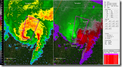
 Here is an radar reflectivity and velocity image showing the mesolow over southern New England. The hurricane like eye shows up very nicely. As you can see the core of the strongest winds were just east of the center. This is where most of the wind damage occurred. The strong winds aloft where transported to the surface. The microburst caused extreme damage from Guilford and Madison north to Ellington. The 40-55 knot (46-63 mph) wind gusts caused widespread damage to the towns in the area impacted by the winds. The most extensive damage occurred in in east Glastonbury Connecticut . The damage survey out of NWS Taunton confirmed a microburst with winds estimated between 70 and 87 knots (85 and 100 mph) hit the area hard. The microburst started near Homestead Drive and continued north to Hebron Avenue. The worst of the damage occurred between Butler Drive and Needletree Lane.
Mesoscale Convective Vortices and mesolow have happened over the Northeast before. But, mesolows of this intensity are quite rare.This event shows you can never let your guard down when there is a threat for severe weather. It also shows how microburst and other types of straight line wind events can cause much more damage than some tornadoes. Well that’s it for now….feel free to ask any questions.
Rebecca

No comments:
Post a Comment
Thank you for taking the time to comment, I will answer as soon as I can.