
I released
my thoughts on the upcoming Atlantic Basin hurricane season on March 23. Today is the 23rd of April. So, I
wanted to post an update.
The 2020
Atlantic hurricane season starts on June 1st. This point in April is a good time to take
another look at the key factors, in order to get a better handle on what
conditions will be like during the hurricane season. I will likely post a final update on this year’s
hurricane season on May 23rd.
The
predictions from other outlets:
Major
weather outlets and universities release hurricane outlooks. Here are the major
ones that gather interest.
Colorado
State University has a prediction of 16 named storms, 8 hurricanes, 4 major
hurricanes, with at least one major hurricane making a landfall on the U.S.
coastline.
The Weather
Channel is predicting 18 named storms, 9 hurricanes, 4 of them becoming major
hurricanes.
AccuWeather
is predicting 14-18 named storms,7-9 hurricanes, with 2-4 becoming major. They
think 2-4 storms could impact the U.S. Coast.
WeatherBELL
is predicting 14-20 named storms, 7-11 hurricanes, 3-6 of them major. They also
believe the Gulf Coast and East Coast are at a high risk for landfalling
tropical systems.
Tropical
Storm Risk (TSR) is predicting 15 named storms, 7 hurricanes, and 4 major
hurricanes.
University
of Arizona is calling for 19 named storms,10 hurricanes, 5 major hurricanes.
North
Carolina University is calling for 18-22 named storms, 8-11 hurricanes, and 3-5
major hurricanes.
There are
two other outlets that I like to look at.
The one from Huston’s Weather Research Center isn’t out yet, or I
haven’t been able to find it if it is out. The other is NOAA itself, but they
don’t release an outlook until the end of May.
Climate
Signals:


Here is a
look at the current Sea Surface Temperature (SST) anomalies, as well as SST
from past seasons, and precipitation rate patterns for August through October.
The North
Atlantic

When we look
back at Atlantic Basin hyperactive seasons, we see a similar SST pattern in the
Atlantic.
The Gulf of
Mexico and Caribbean


The SST’s
across the Caribbean and Gulf of Mexico are warmer than average.
Here is a
look at the SST anomalies in the Gulf. The Gulf is playing a big part in the
highly active severe pattern in April. Those warm waters are going to be a big concern
during the hurricane season. One thing to keep in mind, is many times cool springs, lead to early season tropical activity. not saying it will happen, only something to keep in the back of your head.
The Pacific
Ocean


The SST anomalies
across the Pacific are warm.
ENSO

Earlier this
April we had borderline weak El Nino Modoki conditions in place. Since then we
have transitioned to neutral conditions. The Indian Ocean Dipole is also
neutral. We most likely will stay in neutral territory for the next few months.
But, as we get into July and especially August, we very well could be in a weak
La Nina, that extends into the late fall.
Madden
Julian Oscillation (MJO)


Looking at
the subsurface tropical Pacific SST, we see there is a shallow layer of warm
water near/at the surface, with a cooler pool of water under it. The warm
surface water was west of the Dateline, but now it has shifted near to and a
little east of the Dateline.


So far, the
analog years I’m using are: 1933, 1952, 1953, 1959, 1995, 1996, 1998, 2005, 2007,
and 2017. Most of these seasons saw above average tropical activity in the
Atlantic Basin. In fact, many of these seasons ended up being hyperactive.
When we look
back at past years that were active and compare that to the SST anomalies, I’m
using for analogs We see the SST pattern is quite similar.


2005 and
2017 were very hyperactive 2017 had 17 named storms and 2005 ended up with 28
named storms. When we compare SST from those
two hyperactive seasons to now, we see very similar SST patterns. In fact,
currently the Atlantic main development zone, Gulf, and along the East Coast
are warmer than they were in 2005. Something to at least think about.

During
November wind anomalies were westerly in the Pacific. From mid-December into
mid-March the trade wind anomalies were generally easterly. Then from the end
of March to now the wind anomalies have switched to become westerly in the
Central Pacific. This has to do with the
MJO and SOI.
In the last
two months, negative subsurface temperature anomalies, have
extended from the western to eastern Pacific Ocean.
Positive
subsurface temperature anomalies reside near the surface, except in the eastern
Pacific (100 W-80 W).
Here is the
current SOI index numbers and chart.
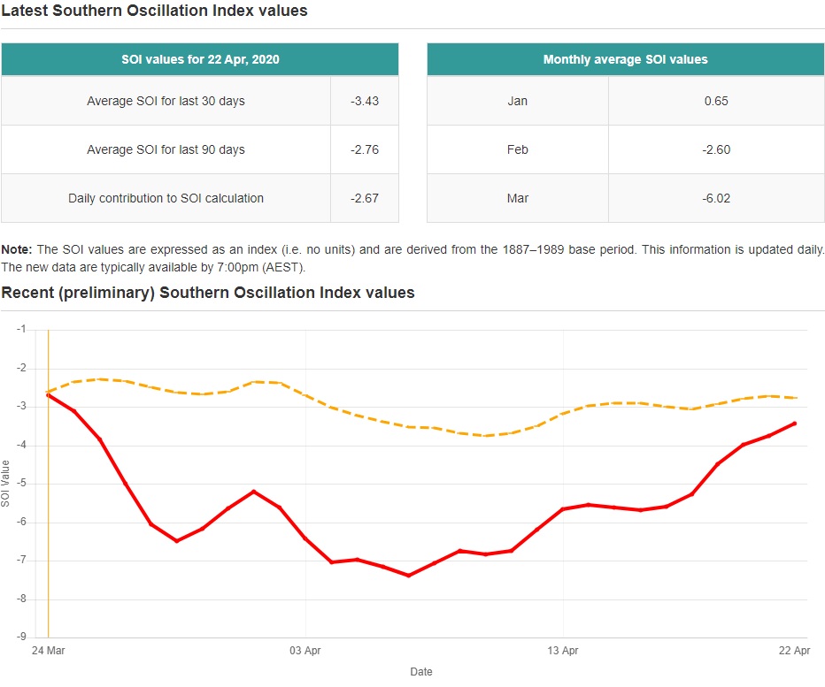
Once the SOI
goes positive the easterly trade winds will increase leading to those cooler
subsurface SST to upwell to the surface.
If the MJO
keeps rotating through phases 2 and 3 this Summer, that would help promote
tropical activity in the Atlantic Basin.
Accumulated
Cyclone Energy (ACE):
Ace is used
to measure the intensity of a hurricane season as well as individual tropical cyclones. The higher the number the more active the season and the
danger level during the season and the greater the damage potential of individual
storms.
The ACE statistics
go back to 1851. Many of my analog years saw higher than average ACE. 1933 holds
the record for the highest ACE; that being 259. 2005 wasn’t too far behind with
an ACE of 250. 2017 ranks 7th, with an ACE of 223.
An ACE value
of 95-105 is considered average in the Atlantic Basin. For this season I'm calling for an ACE well above that.
Where are
my thoughts?
I am
forecasting an above average hurricane season due to a combination of either
neutral ENSO conditions or La Nina conditions, an active Western African
Monsoon, well above average SST and the possibility of lower than average wind
shear conditions. The things I’ve just gone over, shows there is a real
possibility of a well above average season with close in activity being a real
danger this season. This is something that will need to be watched closely.
I still feel
there is a high risk for tropical cyclone impacts for places like Cuba,
Hispaniola, Bahamas, the East and Gulf Coast. When we look back at the
precipitation pattern from those analog and high impact years, we see the
pattern is very wet in the Gulf and along the East Coast. That supports my thoughts on there being a
real risk for Coastal areas of the U.S.
I haven’t
changed my numbers I released a month ago. You can find them here.
Thanks for reading.
No comments:
Post a Comment
Thank you for taking the time to comment, I will answer as soon as I can.