The severe setup for tomorrow is marginal. The CAPE values look to be a bit higher than we saw the other day. SRH values look interesting, as do shear values. Lapse rates look about the same as Tuesday’s severe event. Like I said the indexes are marginal. But, they are such that they generate interest. We will have a strong cold front moving out of the Great lakes. this will likely produce showers and thunderstorms. Rainfall will be heavy at times. At least a few of the storms should become strong / severe. The greatest danger will be strong damaging winds, small hail, and heavy downpours. We will have to be on the watch out for any bowing segments in the line that will develop in the afternoon. But with that said, the severe wind threat should be fairly limited
Here’s a look at the severe index parameters.
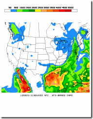
Convective available potential energy (CAPE)
CAPE is a measure of how instable the air overhead is, and the potential for thunderstorms.
normally, CAPE values of 1000 J/Kg are usually adequate enough to produce strong to severe storms. CAPE of 3,000+ shows the atmosphere is very unstable and could produce severe storms if other severe parameters are in place.

Around 5 pm SBCAPE looks to be 500-1000 J/Kg along the Hudson Valley; SB CAPE values of 1000-1500 J/Kg to the Southwest of the CD and south of the Mohawk Valley. MLCAPE looks to be in the 500 – 1000 J/Kg range.
Surface based CAPE at 5:00 pm

Mixed Level CAPE at 5:00 pm
CAPE < 1000 shows weak convection CAPE 1000-2500 moderate convection CAPE >2500 Strong Convection.
Lifted Index (LI)

During the early afternoon around the Hudson Valley and down into the Catskills, LI is going to start increasing. Around 1 pm it will be 0 to –2….then by 5 pm the LI will be –2 to –4. By 8 pm these LI values will be starting to shift to the west of the Hudson Valley.
LI at 2:00 pm

LI at 5:00 pm
When the LI is negative it means that the low level air from the surface up to around 500 mb is unstable, and suggests the possibility of convection.
LI of 0 to –1 is somewhat unstable, LI of –1 to –2 is moderately unstable, –3 to –4 is largely unstable, and LI below –4 is very unstable.
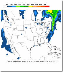
Storm Relative Helicity (SRH)
This is a measure of the rotational updraft potential…it can be useful for forecasting severe weather and the likelihood of of supercells. There are two levels that get looked at…the 0-1 Km and the 0-3 Km level.
Values of 0-3 Km SRH of 250 or greater and 0-1 Km values greater than 100 can suggest an increased threat of supercells and tornadoes

The 0-1 Km SRH is going to be 150 – 200 Km

0-3 Km values will be 250-300 Km.
Lapse rates look to be 5-6 around the Mohawk and Upper Hudson Valleys. with values of 6-7 over extreme southeast NYS and most of New England. This should help keep the wind theat from become widespread. But localized damaging winds are possible
Bulk Shear, values look to be 40 - 70 KTs when the Bulk Shear is 30-40 KTs+ it shows severe storms are possible…maybe even supercells…the question is will we have enough instability to transport this to the surface?
Right now, we should see something similar to what we saw the other day. During the afternoon we will see a thin line of low topped convection (QLCS) develop to the west that will move east.
QLCS is normally a thin intense squall line, usually this type of line doesn’t have a lot of thunder and lightning with it. This is because the strong shear overhead keeps the cloud tops low, generally they stay under 15,000 feet. That may seem tall, but, a summertime thunderstorm can have tops of 30,000 feet or higher. A QLCS line can often have strong gusty winds accompanying the frontal passage. As we saw on Tuesday, this type of line can produce wind gust of over 40 mph.
Timing looks to be more or less like this.
By midday the line looks to be impacting Central NYS and the western Mohawk Valley.Then moving into the Hudson Valley around 5 or 7 pm. This would coincide with the increasing severe indexes, I mentioned above. By 2 am the line should be clear of the eastern NYS and western New England. Rainfall amounts look to be a widespread, 1-2 inches with perhaps more in spots. Right now those with the best shot at severe weather would be south of Albany and the Mohawk Valley into the Catskills and Poconos, but severe weather could popup anywhere along the line.
Well that about it.....just remember to heed all warning given. There could be flooding in poor drainage areas and ponding on roadways. So if your out and about, drive will caution. Also never drive over or approach downed power lines.
Rebecca

Awe-some... How's the codes working out? Page is looking Fine .......
ReplyDeleteThank you Paul....I still working on the code.....I hope to have a least the first page up by the middle of next week..........You have a lot of mixed code in your example........so I trying to ferret out what I need and what I can leave out.......Plus the Open Graph Meta stuff looks interesting, so I'm trying to see if I can code some of the stuff into that.....
ReplyDeleteGreat read.
ReplyDeleteThank you for taking the time to read it...
ReplyDelete