Sunday, August 19, 2012

Winter 2012 -2013 outlook.

Hi it’s Rebecca again, this blog will be about my initial thinking on the upcoming Winter of 2012 – 2013. I've learned a lot from last years winter outlook.  As I told you in last years outlook. I start to look at the indicators around this time of year. Although it is still summer, I start to to turn my attention to the upcoming winter season. This post will stay away from most of the meteorological mumbo jumbo ...but some of it is necessary....I will try to show you how to read and interpret the data for yourself.


Before I get started I want to mention the years I'm using as analogues.... that I am using to try and get a handle on this winter's potential. I used these years where a weak to moderate El Nino followed two La Nina's in a row.

1963
1972
1976
1986
1997
2009

It should be noted that while some of these years could be called neutral, I was looking to see if they were still in negative territory and it seemed that the two years in question remained connected by the same La Nina event, by one way or another. I want to point out, this is in no way a long range winter forecast. Most likely some things will change between now and December. Because I wanted to keep the length of this post under control; I didn’t go into a lot of detail on the different oscillation’s.  So if you want more information here is   Last years winter outlook.  Before I get started I want to briefly talk about last winter.


Why the lack of snow and cold last winter?   The largest problem for snow lovers last winter wasn’t only the La Nina, but rather the temperature of the stratosphere and the Madden Julian Oscillation (MJO). Most forecasters pay attention to the troposphere, but there are  many variables that go into a long range outlook. So when I looked at the stratosphere, I observed that it is beginning to warm slowly as compared to last year when it reached record cold levels, promoting a very warm troposphere. I will talk about this oscillation in more detail later….but for now I want to say that  the MJO plays a major role in jet stream placement. But most of us should remember last winter we had a jet that stayed to the north and  that was very fast, this  kept the pattern zonal. This along with a positive NAO that prevented arctic air from making big moves into the Northeast, and most of the U.S. for that matter.   OK lets get into the data a bit.


The NAO:


What is the North Atlantic Oscillation (NAO) index...it's an index that measures the state of the Atlantic...it involves the differentiation of pressure between Iceland and Greenland down to the Azores and over into Spain. This is just one of oscillations that is important to our winter weather . The NAO helps to create blocking and helps to bring cold air into the northeast when in the negative phase...now it's been in the negative phase Since mid June thru now. The question is will this continue into the winter.


Now many long range weather prognosticators are saying because it's been in the negative phase for so long this will continue...However, I've been looking at the data..... and I say, not so fast. I'm going to turn this into a teaching moment.....I'm going to show my current thinking and why I'm disagreeing about which phase the NAO will be in.


When the NAO is positive the Atlantic is in a westerly phase. This would mean high pressure around the Azores....And low pressure around Iceland...This would mean the winds would be westerly. The more intense the index, the stronger the NAO, the stronger the westerly winds.... So of course, a negative NAO is when there's high pressure over the Iceland and low pressure down around Azores with easterly winds moving over the Atlantic.


The important thing I want you to get out of this is it's not the winds that are driving the NAO... it's the weather that's driving the NAO... and not the NAO that's driving the weather.


 I've been asked , how do you forecast the NAO?  I look at the sea surface temperature anomalies in May into June. The reason we use the sea surface temperature anomaly in May is that they tend to reoccur during the Winter based on my observations .

In May you're looking for a positive anomaly in the tropical Atlantic and a negative anomaly in the Mid Atlantic around the US East Coast. Then you will have another positive anomaly just south of Greenland and Iceland. This would mean a warm band of water in the tropics, cold band in the middle Atlantic, and a warm band from Newfoundland to south of Greenland and Iceland.


 So if you see that setup in May it's normally a good indication you will see the same setup during the Winter....that would consequently mean the NAO would be negative and that would imply an area of blocking high pressure setting up around Greenland and low pressure setting up south of the blocking high.  Ok let's take a look at how the Index looked for May 2012. what we look at is an average of cold water anomalies.

 Here are three maps of the SST anomaly for May 2012


SST May 9   5/9/2012, what we see is an average of cold water anomalies around the tropical Atlantic. and an average of warm water anomalies south of Greenland. There are warm SST from Newfoundland over to Greenland .... However, There is hardly any real warming in the tropical Atlantic.


SST may 16
5/16/2012 ,We see cooler than normal waters through the tropical Atlantic with no real band of warm water band setting up. East of Newfoundland and the Northeastern seaboard the SST has increased a bit. ..but the bottom line is there is not a lot of warm water in the tropics.


SST May 30
  5/30/2012, Again there is no sign of a warm water anomaly around the equator in the tropical Atlantic. and again warm off of Newfoundland. This is basically telling me that we are most likely to see a positive NAO for the winter of 2012-2013.      


Now before you send your cards and letters.....let me say the way I read the NAO is a theory and is experimental....but it is based on observations and patterns that have occurred in the past. This is just where my thinking is at this time.....It more than likely will change to some degree, as we get closer to the end of October and November.


When making a winter long range outlook; there are other things I look at as well.........The sea ice extent and how it behaves during the Summer, How quickly the snow builds in Siberia, ENSO (La Nina or El Nino), and the PDO. There are other things as well, but those are the main ones.


The ENSO:


El Nino is a warming along the dateline of the Pacific equatorial waters off of Peru over to Indonesia . And the area that must see warming to get a designated El Nino is the mid equatorial region. this area must stay warm for five cognitive monthly recorders. when that happens we get an official El Nino declared.

 Here's the latest Sea Surface Temperature Anomaly map.


anomnight_8_16_2012latestfullglobe When you look at the NOAA SST anomaly chart there is significant warming from Peru into the mid equatorial region of the pacific. It's not an intense warming There is no darker orange or red showing up....so this is telling me during the winter of 2012 -2012 will see a weak to moderate El Nino.


As a side note....if you look at the SST above you will see the water is warm from Newfoundland over to Greenland....As I said above I look at sea ice ... The warming around Greenland  as as caused a lot of blocking in the atmosphere more most of the Summer near Greenland. Because of this there has been an awful amount of ice melt in Greenland this Summer....This could have implications on the winter of 2012-2013...but it's too early to talk about that....I will return to this at the end of September into the first part of October.


Unisys SST chart _anom
Unisys SST chart again you see the warm water temps off of Peru and extending well into the central equatorial Pacific. You can also see the cool SST in the Gulf of Alaska heading down into the waters of the Pacific Northwest and the Central northern Pacific.....This is showing the PDO in a positive phase.  When you see Positive PDO during an El Nino....The El Nino has a hard time keeping a foothold......this is why we're not seeing more warming along the dateline.....This is telling me there won't be a strong El Nino this coming winter.


When I looked at the SST in the Pacific for the 80's and 90's....the El Nino's during that time were very intense.....that was because the PDO is in a negative warm phase....this allowed the El Nino's to strengthen much easier.


It's sort of like trying to get hot water out of the kitchen faucet when you also have the cold water tap on...


  SST anomaly from Jamstec IOD  ssta_glob_JamstecSST   This shows the warm water stretching all the way from Peru almost to Indonesia. This model is forecasting a moderate El Nino...This also shows the cold water from the Gulf of Alaska and along the Northwest coast. You can see that this El Nino looks to be east based.


ssta_glob_DJF2013_1jul2012dec-FebIf you continue into Dec to Feb it shows the El Nino is better organized....this is normal because El Nino typically get's stronger around Christmas time. But you can see the water temperature is starting to cool off near Peru.


ssta_glob_MAM2013_1jul2012marchthrumay Now you can see the cooling is very evident out into the middle equatorial area.
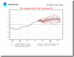


nino34SSTMon   Most of the ensembles are showing a weak to moderate El Nino. CFS v1 and CFS v2 show a long duration weak El Nino. When the SST is at 1 degree Celsius it’s showing a weak to borderline moderate...under 1 degree C is weak....over 1 to 1.5 degree C is moderate.... anything above 1.5 to 2 or 2.5 degree C is strong to very strong ....The CFS V2 is not showing anything getting into the strong category.


The atmosphere is still not into a El Nino state....it's still more or less still into a La Nina state...but that should chance in 6 to 8 weeks....but the bottom line is a weak to borderline moderate El Nino is very likely.


The PDO:


As I said, the PDO is going into a positive phase. (waters in the northern Pacific will be colder) There have been La Nina years that have been very lean ( as we saw last year).There have been El Nino years where we received a lot of snow. The reason for all this are variations is the PDO. Last year, we had a moderate to strong La Nina....however the PDO was negative.


When we have a negative PDO the storms coming into the Northeast don't have a lot of cold air to work with. With the PDO heading  into positive territory...this should allow the cold to infiltrate farther south than it did last year. Therefore the East Coast and again the Northeast could see more cold air outbreaks than we saw for the winter of 2011-2012 (that wouldn’t be too hard considering how warm it was).


The Madden Julian Oscillation (MJO):


The Madden Julian Oscillation will be shunted into Octets 8-1. This is significant, because the MJO is a measure of pressures and temperatures over the Indian Ocean, which because of the amount of energy contained in that ocean control the global weather patterns..including jet stream patterns and SST’s. The MJO is one of many factors that contribute to the development of tropical cyclone The El Nino will become west based driving (Left- an example of a west-based El-Nino in 2003) the MJO into a favorable pattern for pushing the moisture stream into the west coast, and may result in the formation of more storms. This oscillation will also balance the core of warmth over Alaska and Siberia, as compared to last year when it was incredibly cold and snowy and the east coast was kept into a ridge of higher pressure.


Winters with weak-to-moderate cold, or La Nina, episodes or ENSO-neutral conditions are often characterized by enhanced 30–60 day MJO activity. A recent example is the winter of 1996–97, which featured heavy flooding in California and in the Pacific Northwest. The winter of 1996-1997 has become the bench mark that all other winters are judged against. That winter saw several Midwest and Northeast snowstorms including the Blizzard of 96 on January 6-8, 1996 and the March 31 - April 1 1997 Blizzard.


Given the aforementioned factors, This will translate into a ridge further west, mainly west of the Mississippi River, resulting in warmer than average temperatures, and below average precipitation, further worsening the drought situation. The far west coast, may have to deal with a consistent stream of weak to moderately strong storms which may dip further south. Depending on how cold it gets the Northeast could see more than a few storms. This also potentially gives the southeast a better shot of ice storms as the jet stream sags further south delivering a few major cold snaps.


Ok what does all of this mean?


Weak El Nino’s on average have a much greater effect on the east coast ..especially the Northeast. weak El Nino typically brings slightly below average temperatures to the country, while bringing more precipitation to the East Coast and below normal rainfall for the Southeast.


Normally during a El Nino the temperatures along the East Coast are below average Dec-Feb With this being said, I expect this Winter to not be like a typical El Nino, especially with regards to precipitation trends. This will largely be as a result of the cool phase of the PDO and the suppression of the subtropical jet further south.  Snow in the eastern US would occur mostly from North Carolina north. With Ice in the more likely in parts of Texas, into the Tennessee valley and parts of the Southeast.


If the NAO does go positive we might not see much of a Greenland high. We wouldn’t  see a pattern as zonal as we saw last year…but it would cut down on precipitation amounts. We would see a few Nor’easters; just not as many as we would see in a normal El Nino winter. However, if we see the NAO go negative then SE NYS and southern New England would end up seeing above average precipitation. This would include the Mid Atlantic.


But right now I think most of New York State and northern New England will see average to slightly above average precipitation, with southern New England and Southeast NYS seeing average to slightly below average precipitation.  I think there is no doubt we will see more cold weather during  winter 2012-2013. I’m not 100% sure how cold it might be. Right now, I feel we will see a slightly colder than average. I hope you notice I'm using the word precipitation and not snow......winter precipitation includes rain, snow, ice, and freezing rain.


I want to close with this. Most of the data I’ve seen is pointing toward the possibility of seeing a decent winter cold and snow wise…The analogs show that back to back La Nina’s followed by a Weak El-Nino saw very substantial winters 60% of the time. The only thing that’s keeping me from thinking that... is the fly in the soup...THE NAO...the NAO I saw in July. remember  many times that pattern repeats  again in December or January. However if the NAO does stay negative we could be in for a brutal winter.  I will be back with an updated winter outlook in six to eight weeks……..BUT remember these were just my  initial thoughts on the upcoming Winter of 2012 – 2013.


I hope you learned a thing or two…and most of all enjoyed reading this post…….I will be happy to answer any questions anyone has.


Rebecca


Tuesday, August 14, 2012

The Long Island Tornado and Microburst in Connecticut

  Hi it Rebecca again, the subject of this blog post will be the mesoscale convective vortex and mesolow that caused all the damage on Long Island, NY and southern New England last Friday.

August 10th was This certainly was an unusual severe weather day across Southeast New York State and southern New England. Friday morning started out with a low pressure system with accompanying cold front moving out of the Great Lakes CAPE and other parameters were good but not greatly impressive. However As the day went on the indexes got better. During the afternoon, the line of storms moving into eastern Pennsylvania started to push into 3K+ CAPE, -5 to -7 SBLI, and 2" PWAT. Once the storms got into this air they exploded. The storms developed into a mesoscale convective system (MCS) (a large area of organized storms). The MCS continued to move east.

The conditions that lead to the MCS continued to intensify the storm. There was a narrow but very intense low level jet parked over southeast New York State and southern New England. When the storm moved along the eastern side of this jet streak it caused parts of the storm to curl back on themselves. This give birth to a mesoscale convective vortex (MCV). An MCV is a small area of low-pressure located within a mesoscale convective system that pulls winds into a circling pattern. This forces the storm to increase its spin rate and the winds to increase.


TornadoWhen the MCV moved over eastern Long Island it produced an EF0 tornado. The tornado formed at 2:06 pm in Suffolk County near Great River and traveled north across Ronkonkoma and Bohemia. The tornado had wind speeds of about 85 miles per hour and left a path of knocked-down trees and piles of debris on a track that ran for 41/2-miles.  However, things were only getting started. The forces acting on the storm forced the storm to further intensify.


181181_10151104985009169_258760206_n
I snagged this from extreme storm chaser Reed Timmer’s Facebook page. It shows six supercells out over the Atlantic heading into New England. All six were mesocyclones. The supercells would later cause wind damage in portions of Washington and Kent Counties in Rhode Island.   Winds gusted to near 60 mph on Block Island, RI  


Once the storms moved into southern New England, the intense area of thunderstorms developed into something called a mesolow. A mesolow is a small area of low pressure, ranging from the size of a few miles to many tens of miles across. A mesolow becomes so intense that it even has a eye-like formation at it's center, that makes it look like a miniature hurricane. The severe weather potential often increases in the area near and just ahead of a mesolow.


 glastonburybarograph

The mesolow was very strong, mesonet stations around the area before the event showed readings of 1008 mb – 1007 mb , stations showed steep pressure drops in less than an hour..The image on the right is a barograph from the mesonet station at Glastonbury. The pressure went from 1007.5 mb to 1001.0 mb in 40 minutes.


 The tornado marked the area where the mesolow was beginning to form. It reached maturity over Connecticut and Massachusetts.


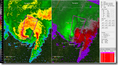
    post-3065-0-86596200-1344630849 Here is an radar reflectivity and velocity image showing the mesolow over southern New England. The hurricane like eye shows up very nicely.  As you can see the core of the strongest winds were just east of the center. This is where most of the wind damage occurred. The strong winds aloft where transported to the surface. The microburst caused extreme damage from Guilford and Madison north to Ellington. The 40-55 knot (46-63 mph) wind gusts caused widespread damage to the towns in the area impacted by the winds.   The most extensive damage occurred in in east Glastonbury Connecticut . The damage survey out of NWS Taunton confirmed a microburst with winds estimated between 70 and 87 knots (85 and 100 mph) hit the area hard. The microburst started near Homestead Drive and continued north to Hebron Avenue. The worst of the damage occurred between Butler Drive and Needletree Lane.


 Mesoscale Convective Vortices and mesolow have happened over the Northeast before. But, mesolows of this intensity are quite rare.This event shows you can never let your guard down when there is a threat for severe weather. It also shows how microburst and other types of straight line wind events can cause much more damage than some tornadoes. Well that’s it for now….feel free to ask any questions.


Rebecca  


Monday, August 13, 2012

Was it a tornado or something else?

Hi it’s Rebecca again. In light of the cloud misidentification that occurred in Sidney. I thought I would post on things that are often mistaken for tornadoes.

The sight of low ominous clouds in the summer is fairly common. During a storm people often take very impressive pictures; these pictures are often sent into TV stations and blog sites accompanied with the question “was this a tornado?” This post will discuss things that are often misidentified as tornadoes. If you’ve been guilty of this in the past, don’t feel bad, even experienced spotters can make the same mistake.

Fractus Clouds:

These are the clouds that are most often mistakenly thought to be a funnel cloud or even a tornado itself. Fractus clouds are also known as scud clouds.

Scud clouds are created when the cooler outflow is interacting with the warm air ahead of the storm. when this warm, moist air is lifted upwards. The environment is such that the rising moist air is quickly cooled which forms a cloud. When this happens in front of a thunderstorm, the wind can push the clouds away from an updraft, causing the clouds to away from the storm. This gives the clouds a ragged and wispy look. Scud’s can change shape rapidly. If the scud’s are in a outflow they can move fairly quickly. If they’re caught in an updraft they normally rise and may even show some lateral movement.

Scud clouds are not dangerous taken by themselves. However, their presence often is a good indictor that strong gusty winds are in and around the storm.
Fractus clouds are also mistaken for wall clouds.

Wall cloud 2
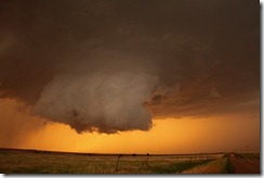
This is a picture showing what a wall cloud. Wall clouds can take on many forms but normally they look like this. From looking at it, you can see why shelf clouds are sometimes mistaken for a wall cloud. The presence of a wall cloud can be an indication of a mesocyclone but not always. usually a shelf cloud is on the leading edge of a storm. Whereas a wall cloud is seen more or less at the rear of a storm.


wall_cloud  Photo by CWG photographer Ian Livingston
Wall clouds are often associated with tornadic thunderstorms but not always, and many wall clouds do not rotate. However, the presence of one is more often than not a sign of a mature severe thunderstorm. When the wall cloud is rotating a tornado could drop down. The wall cloud aids in tornado development because it brings the base of the cloud much closer to the ground.


is it a wall cloud no it's a scud
Is this a wall cloud? No this is just a scud. But you can see how the mistake could occur.


wallcloud tailcloud
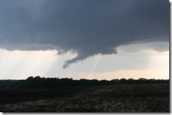
A wall cloud accompanied by a tail cloud. The low-hanging, tapering feature at right is called a tail cloud, and is an inflow feature. A tail clouds often forms between the low level mesocyclone and the forward-flank core. A tail cloud forms  below the level of the main cloud base. Tail clouds sometimes have very fast, horizontally tilted rising motions. Because they can hang so low, look a lot like a funnel, and contain rapid cloud movement, they are sometimes mistaken for tornadoes. The key with suspicious cloud features is to look for rapid rotation, and evidence of spinning debris under the cloud base.
NOAA Photo Library, NOAA Central Library; OAR/ERL/National Severe Storms Laboratory (NSSL)

Precipitation shafts:

These are areas of rain and/or hail under a storm. A precipitation shaft can fool people into thinking there’s a tornado. The best way to tell what you’re looking at is to watch the motion around the area Most of the time in a precipitation shaft you will see a downward motion. Whereas if it's a tornado you will notice a rapid rotational motion. A tornado will change shape very quickly, while the area of precipitation in a shaft will change shape very slowly.

Rainshaft2
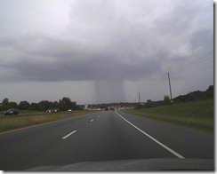
Here is a picture of a rain shaft. In this picture there is a very thin but intense rain shaft. This kind of thing can fool untrained people or inexperienced spotters can be fooled into reporting a tornado. In this type of situation you should always look for signs of rotation or power flashes. But sometimes rain shafts can look so much like a tornado that even veterans spotters are fooled.  This type of misidentification is especially true if the storm is a few miles away; because it’s is near imposable to tell if it’s rotating. But in the heat of the moment it’s always best to call in a specious lowering.

Before I close I will show you a few more pictures of scud clouds.

                                                use it              
                                                       A very impressive scud cloud

                                                 123
          
181105_448968915134486_2050107932_n
Here is a picture I snagged from the NWS Morristown, TN. This photo was taken my Bean Station. It’s one of the most impressive pictures of a tornado lookalikes I’ve ever seen.As is the case of all pictures it hard to tell if this is a tornado because it’s very hard to tell if there is any rotation. Also it's hard to tell which direction the storm is moving.  But there are other clues in the picture that tell us it’s not a tornado. If you look at the pictures of wall clouds above, you will notice there isn’t a wall cloud in this picture (not all tornadoes are accompanied with a wall cloud. However, most tornadoes are associated with a wall cloud). What you’re seeing is a shelf cloud (the arched blue line). Rain is always behind the gusty winds under the shelf cloud. So now we know the direction the storm is moving (shown with the yellow arrow). Now the scud cloud (red arch) is being pushed in the direction of the strong winds. This shows why you should always look for all the clues you can in trying to determine if you’re seeing a tornado or not. Because as this picture shows scud clouds can be convincing enough to fool even highly trained individuals.

As I said in my last post, things like downburst,Rear Flank Downdraft, Roll clouds, and Shelf clouds are also misidentified as tornadoes. The main things to look for when you think you see a tornado are: rapid rotation, power flashes, and debris in the air.

Here a two links to post I’ve done on Tornadoes and severe weather.

The Tornado
Clouds associated with severe weather

I hope you enjoyed this post. As always I will be happy to answer any questions you may have.

Rebecca. 

Tuesday, August 7, 2012

Tornadic Winds versus Straight Line Winds.

Hi it's Rebecca here again, With the Tornado in Elmira, NY last week and the microburst in Sidney this week; There has been quite a bit of severe weather lately. When the NYS damage survey team determined it was  straight line wind damage in Sidney, NY on Monday; it  caused a bit of controversy, many still feel it was a tornado. This is based on several people saying they saw what looked like a tornado, the rotating wall cloud, and people heard a roaring sound. Because of this,  I thought I would talk about the difference between tornadic and straight line winds.


On Sunday August 5 2012,  thunderstorms ahead of a strong cold front produced quite a bit of damage reports; most of these were in Western NYS. However, one storm near Sidney, NY in Delaware County caused the most widespread damage.

What is a storm survey?

when storm conditions and damage occur as happened in Sidney on Sunday; the local NWS field office assigned to that area sends out a damage survey team; whose job is among many things to determine if the damage was caused by a tornado or straight line winds. No two surveys are ever the same..Some surveys are easier than others...but there is no such thing as an easy storm damage assessment survey. There are two types of damage surveys..ground and aerial... In the case of a ground survey, the highly trained team will go to the damaged area. If the damage path is known the team will most likely start at the beginning and walk through to the end notating damage as they go. If the damage path is not known they will often start at the most damaged area and fan out normally into two person teams....They are always looking for and at the big picture.  

A damage survey consist of many things: interviews, taking pictures and video of damaged areas, documenting the type and quality of construction of the damaged building, the type of construction materials use in the building, the type of damage that occurred to the trees including the type of tree it was. These are just a few of the hundreds of things and parameters they are looking at.  

The ground survey can also take a considerable amount of time so often the amount of detail collected is determined by the scope of the event and available time/resources. A small, isolated damage spot might favor detailed examination while widespread or extensive damage might need to be summarized by a few, quick stops.

What's the difference between a tornado and straight line winds?

A tornado is a vortex of air extending upward from the ground  into the base of a thunderstorm, that is intense enough at the surface to cause damage. The condensation funnel may not always be visible from cloud to ground.

Straight line winds are very strong winds that produce damage that shows a lack of a rotational damage pattern. Straight line winds are common with the gust front of a thunderstorm or originate with a downburst from a thunderstorm.

But the one thing they have in common is both contain winds capable of causing extreme damage on the ground. Straight line winds can be just as damaging or even more damaging than a tornado.


Types of straight line wind:


The setup for straight line winds is: when you have strong updrafts and downdrafts overhead, the middle layers of the atmosphere have dry air, and the line of storms are moving very fast.  We had all of that last Sunday.

As most of you know, meteorologist use lots of terms that seem to talk about the same thing. Well this applies to straight line winds as well, straight line winds can be called convective wind gust, downburst, outflow, and as was the case in Sidney.... Rear Flank Downdraft (RFD).

A downburst is a strong downdraft which causes damaging winds on  or near the ground.

Downburst can be classified as a microburst or a macroburst. The only real difference between the two is the size of the damaged area. But both can cause widespread tornado like damage.

Microburst:

Damaging winds occur over an area of 2 1/2 miles or less. A microburst can last as long as15 minutes.

Macroburst:

Damaging winds occur over an area larger than 2 1/2 miles. A macroburst can last as long as 30 minutes.

The other type of straight line wind I want to talk about is RFD.

RFD is a type of downdraft that develops at the back edge of a rotating thunderstorm (mesocyclone). This warm and dry air is forced down out of the mid levels of the thunderstorm. I think this is caused by barometric pressure that is rapidly lowering very close to the ground. The presence of RFD is a very good indication that a tornado is in the process of forming. RFD gives birth to and causes the death of tornadoes.  The RFD descends to the ground along with tornadic circulation. RFD often causes damage when it hits the ground and is wrapping around the mesocyclone. RFD causes the death of a tornado by wrapping around the mesocyclone and cutting off the inflow to the tornado. In the case of Sidney last Sunday, I feel the tornado was within a minute of forming. When the RFD hit the ground it interfered with the inflow just enough that the tornadic circulation was interfered with. Because of this the circulation was unable to complete the process of establishing a connection between the base of the storm and the ground.   


The best way to determine if it was straight line winds or a tornado is offen from the air. Here are two pictures of storm damage. At first look they both look very much the same. However, when you take a closer look you will see differences between the two.


A damage picture taken by Gary Klindt, airport manager at the airport near Sidney. The picture was taken  near the Sidney Airport...In the picture most of the trees are more or less in the same direction..........some of the trees are in a slightly different orientation on the left and right hand sides but that is about it.....I grabbed this from the NWS Binghamton Facebook page.


This is a picture of tornado caused tree damage taken after a tornado moved across Wolfeboro NH Through Effingham NH back in 2008. If you look you can clearly see how the trees are laying in all different directions across the picture.

Why are downburst mistaken for tornadoes?

They both have damaging winds.
Wind in a tornado can range from around 60 mph to over 200 mph. Downburst have had documented winds of over 165 mph.
Both can cause trees to have that twisted look often associated with a tornado.
If you've ever looked at a tree you should have seen the tree is different all the way around it. The limbs and leaves are in different places, even the bark can have differences from one part of the tree to another. All of these things cause the wind to hit some parts of the tree harder than others. Because of this the tree will start to twist. So even if the winds are straight line if they're strong enough they will force the tree to tear in a twisting motion.
As I said above, some people heard a roaring sound in the storm. Winds that are very strong are also very loud.  This can cause people to think they heard a tornado when in fact it was straight line winds.
I hope this helps clear up some of the confusion and sometimes mistaken ideas some of us had. As always I will be more than happy to answer any questions you might have.
Rebecca

What does the term Bombogenesis mean?

Hi Rebecca here again with another blog installment,  I meant to write this last week. However with the severe weather I had to postpone it until now. Anyway, let's get into today's subject. Most of us have seen it, been a bit of worried by it, and even had to do quite a bit of work because of it. I'm talking about  a storm coming up the coast that rapidly intensifies. The result is a huge mess, we have feet of snow, hurricane force winds, downed trees, and widespread power outages that can last for days.  Meteorologist call a storm where the pressure drops very rapidly a bombogenesis. This post will cover what a bombogenesis is, what ingredients are needed to form one, and a brief history of a few of the noteworthy ones of the past.


                                                                                   The October 26 2010 storm


Fronts and pressure systems:


When two different air masses meet, a front is formed. The boundary between these masses is called a stationary front. The air between the two masses never really combines. The stationary front may only last for a few days. One of the air masses, usually the colder and drier mass, pushes to the south, while a warmer and moister air mass moves up from the south.  In the northern hemisphere air masses will to move to the right of the direction that they were originally moving. High and low pressure systems are defined by their direction of rotation, counterclockwise  is a low pressure system, clockwise is a high pressure system. The low pressure center forms along the stationary front. As the system spins, a cold front and a warm front are created. The cold front is the leading edge of the cold air. This cold air pushes under the air in the warm sector. As the warmer air rises clouds are formed.


Fronts are associated with larger storm systems known as mid-latitude cyclones. A mid-latitude cyclone is a weather system that includes a well-defined surface low-pressure area and associated warm, cold, and occluded fronts.  An occluded front is when  a cold front overtakes a warm front and joins with it.


Cyclogenesis is a term that refers to the development of mid-latitude cyclones.


The ingredients:


The timeframe for bombogenesis is normally from October to March. The perfect setting involves a large temperature difference between the high and mid latitudes.  This make the Northeast a prime canadate for these type of storms. We have cold arctic air spilling out of Canada's cold dome and have the Gulf Stream running along the East Coast. Also the strength and placement of upper level winds is key.  Storms need energy and winds equal energy. The wind draw in cold air on the northern side and warm air from the southern side. The winds will increase the temperature difference, increase the upwards motion, and decrease the central pressure. This will keep going until the temperature difference is erased.  The end result is when the mid-latitude cyclone reaches rock bottom and the central pressure drops at least 24 mb in a 24 hour period, when this happens a bombogenesis is born.  

A bombogenesis is nothing more than an extreme cyclogenesis of a mid-latitude cyclone.

The East Coast of the United States during the colder months of the year, is the perfect breeding ground for storms to intensify rapidly due to the warmer waters of the Gulf Stream and the positioning of the low between two very different air masses. The Nor'easter's we see in the Northeast are usually the result of a bombogenesis. Now while most often bombogenesis are seen on the East Coast the Midwestern states and the Great Lakes have seen them as well.  


Notable Nor'easters

The Great Blizzard of 1888 March 11 - March 14). This storm has been called the granddaddy of all Nor'easters. We can only imagine the impact of four feet of snow when the main means of snow removal consisted of horse and buggy. The storm was very intense, snow amounts of 40 - 50 inches along with winds of 45 to 50 mph, caused snowdrifts  in excess of 50 feet. The storm caused more than 200 ships to be grounded or to be sunk. The great white hurricane paralyzed the east coast from the Chesapeake Bay all the way to Maine. Railroads were shut down and people were confined to their houses for up to a week.  All the coastal cities in the region were hard hit. However, New York City was given a killer blow. The storm left New York with a paralyzed transit system, non-existent communications, two hundred people died  in New York City from an estimate of four hundred casualties (most likely more) across the East.


The Ash Wednesday Storm of March 6–8, 1962. It has been called one of the most destructive storms ever to affect the Mid Atlantic states.  The storm ended up killing 40 people, injuring over 1,000, and causing hundreds of millions in property damage in six states.

The 1991 Perfect Storm, also known as the Halloween Nor'easter of 1991. This storm started when a area of low pressure moved out of Canada. This storm  absorbed Hurricane Grace and near it's end it  evolved into a small hurricane with winds of 75 mph on the 1st of November. This storm sunk the Andrea Gail with all hands lost. This Nor'easter is also the same storm that was featured in the movie  "The Perfect Storm" with George Clooney.


The Storm of the Century, also known as the ’93 Super-storm, or the Great Blizzard of 1993.  The storm dropped snow as far south as the Florida Panhandle and snowfall amounts were measured as deep as 16 inches in parts of Alabama.  In the northeast, the nor'easter left behind two feet of snow in Hartford Connecticut, 43 inches fell in Syracuse, New York, even New York City saw over 12 inches of snow.


I'm sure most of us can remember the  Halloween nor'easter in 2011. The storm broke snowfall records in over 20 cities and left millions in the dark for over a week.


When the skies of October turn gloomy:


I've been on the waters of Lake Ontario numerous times...I've also been on and around the other four Great lakes as well......I can tell you, I've seen the Witch of November.  Those who live around the big lakes or venture on them...pay very close attention to the sky in the Fall.... I'm not talking about leftover Halloween witches....I talking about bombogenesis. A November Witch is what those around the Great Lakes call a late fall violent storm.  The Great Lakes are home to weather systems that  are like nowhere else in the world. The waters of Lake Ontario and the other Great Lakes are still very warm in the late fall. When cold arctic air rushes over them and meets the warm moist air intense storms are created . These storms bring sustained winds of 50 to 80 miles per hour with gusts of 90 to a 120 miles per hour and waves of 20 to 40 feet. The greatest witch I've seen was the November 2003 storm that moved over Lake Ontario. I had just got back home from a storm chase in Wooster, OH. So I spent the day down by the shore.  The witch had waves  of 10 to 18 feet high with huge breakers coming ashore. I had rain mixed with snow and ice pounding me. The winds were so strong it was almost impossible to stand... to me this was fun..... . I know I'm strange....The witches are the major reason the Great Lakes are called the graveyard of ships and sailors.

Undoubtedly the most infamous November Witch was the one that sunk the Edmund Fizgerald in 1975 on Lake Superior.

The November Witch of 1913 has been dubbed the White Hurricane because snow produced blizzard conditions. The storm sunk19 ships and 250 people lost their lives.

The November Witch of October 26, 2010 was one of the most powerful storms to ever move across the Midwest and Great Lakes. Meteorologists called it the biggest non-tropical cyclone ever recorded.

The five most intense Great Lake bombogenesis on record.


1. The Great Ohio Blizzard - January 26, 1978 (958mb/28.05 inches).

2. The October 26-27, 2010 (at 955mb/28.20 inches).

3. Armistice Day Storm - November 11, 1940 (967mb/28.55 inches) and Anniversary Storm - November 10, 1988 (967mb/28.55 inches)

4. Cyclone of 1913 - November 7-9, 1913 (968mb/28.60 inches)

5. Edmund Fitzgerald Storm - November 10, 1975 (980mb/28.95 inches)


Well that's about it. You should now have a good understanding of what a bombogenesis is. Hope you enjoyed the post.


Rebecca