
Today is the 1st day of
meteorological winter. So, it seems fitting that I release my 3rd
and final installment of the 2020-2021 Northeast Winter Outlook at this time.
Over the last few months, I’ve
released parts 1 and 2 along with several post on the Facebook weather pages.
If you missed the first two parts. You can find them in the links below.
Before I get started, I want to point
out, in spite of all the work that I do, on these seasonal outlooks. I want to
point out, Short range forecasting is difficult; but long-range forecasting is
much more challenging and imperfect. Seasonal outlooks are as much about science
as they are an artform. They are designed to give a broad overview of what I
expect to happen this winter in general. They aren’t designed to give details
on when storms will happen, when it will be cold or warm. Nor are they about
how much snow will fall in your backyard. They are about averages and cover the
entire Northeast and northern Mid Atlantic. So, while I try to be accurate. Most of my
outlooks have been in the relative ballpark; but there have been outlooks that
didn’t go the way I thought. I have a
degree in this stuff, but an outlook is just an educated guess as to what I
think will unfold this winter. So always take them with a grain of salt, as they
are painted with a wide brush.
Well on to My official
2020-2021 Winter Outlook!
Last winter’s
forecast wasn’t great!
Most of the winter outlooks for winter
2019-2020 were wrong. Mine got some
things right, and some areas turned out as expected. But for the most part it was
a bust, at least according to me.
So, what
happened?
Back in November of 2019 it looked
like a sure bet that we were heading for a weak centrally based El Nino in the equatorial
Pacific. With the mild central Pacific
SST and the warm pool south of Alaska. This set up normally means there is a
lot of ridging near Alaska. This same general pattern was in place for the
winter of 2013-2014. During the Summer and Fall of 2019 things were going as
predicted. But once we got to December the entire pattern flipped and stood on
its head. The Alaskan ridge collapsed. Other than a few brief occurrences of
the Alaskan ridge, it was absent for the entire metrological winter, this
pattern is called a positive EPO, which was the exact opposite of the negative
EPO I thought would occur.
Summer and Fall 2019 saw a lot of high
latitude blocking near Greenland. But once we got into December, the blocking
just disappeared for the most part. The models saw what was going to occur, such
as the AO and NAO staying mostly positive; but I dismissed that idea, the fall
pattern just didn’t support what the seasonal models were selling. But I was
wrong on that as well.
The MJO stayed primarily strong in the
warm phases of 5 and 6.
Another factor that I always look at
is November temperatures. November 2019
was substantially colder than average, based on the 1981-2010 average. Which
tends to lead to colder and snowier conditions here in the Northeast. But when
we look back, we can see that didn’t happen at all.
The polar Vortex was another major
culprit. It stayed very strong and
compact and sat over the North Pole for the most part.
All of these things and others
conspired against me, and stabbed my outlook in the back.
Anyway, what about winter 2020-2021?
Analogs:
1933-1934, 1950-1951, 1954-1955, 1985-1986, 1995-1996, 1998-1999, 2005-2006, 2007-2008, 2010-2011, 2016-2017, 2017-2018
1933 1934 had a similar pattern as we’re in now; the polar vortex tended to be situated on the North America side of the Pole.
Sea Surface
Temperatures (SST):

Pacific SST:
El Nino Southern
Oscillation (ENSO):
The ENSO is about SST in the tropical
Pacific. Warmer than average temperatures are referred to as El Nino, whereas
cooler than average temperatures are referred to as La Nina.
Looking at the SST chart, we can see
the cooler than average waters in the eastern Pacific, these cooler than
average temperatures have lasted for 3 months, meaning we’re currently in a La
Nina. That will have a big impact on this winter.
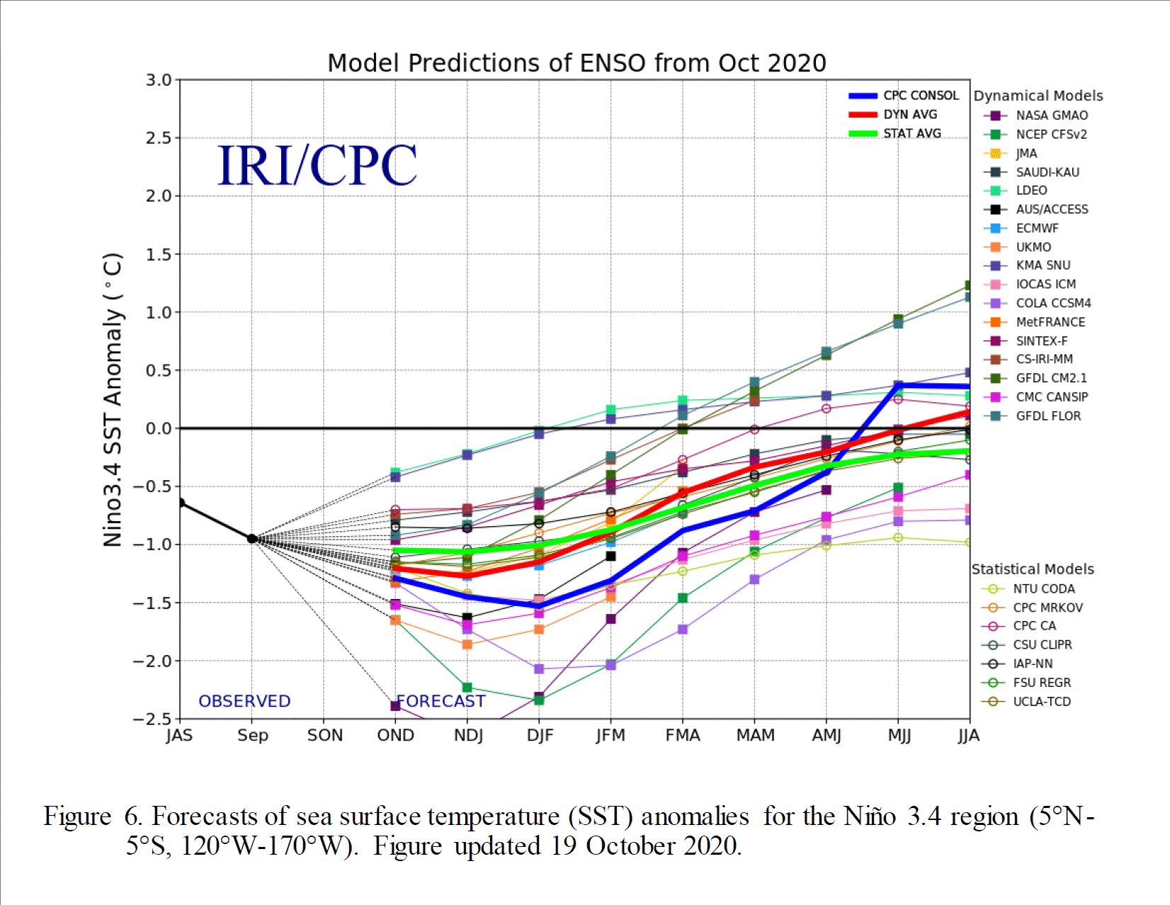
Here is a look at the IRI/CPC plume,
showing the Current La Nina should last through at least the winter.
Based in part on this NOAA seasonal forecast
for December through February looks like this.


La Nina:


Images from Tropical Tidbits
La Nina continues to get stronger.
Right now, the La Nina is a strong
sided moderate. So, this winter should feature a moderate to strong La Nina.
Right now, the La Nina is basin wide
across the Eastern and Central Pacific, but SST analysis does show, this La
Nina is becoming more central based. A Central based La Nina isn’t good for
snow on the East Coast; as it typically brings about warmer temperatures and
less snow.
During La Nina, the polar jet stays a
bit farther north, and the Subtropical Jet is less active. This setup leads to less chances for
nor’easters; doesn’t mean we won’t see any, just means that the odds favor
having fewer Coastal Storms.
The strength of the La Nina should
alter the course of the northern Jet, and force it farther west and north than
usual this winter. The Jet Stream in this orientation would likely lead to more
in the way of western runners moving over the Great Lakes or running along the
Appalachians. This type of storm track would mean eastern Pennsylvania, eastern
New York State, New England, and the Middle Atlantic would be at a higher risk
for mix/ice/rain events instead of snow.
Western runners do tend to produce lake effect snow as they move away.
So closer to the Great Lakes and far Northern New York State and Northern New
England, would have the best chance of seeing average to above average
snowfall. But that will depend on the timing of any cold air we do end up
seeing. But being primarily on the
eastern side of the storm track will make it harder to hold onto any lasting
snowpack.
The Northeast Pacific
Heat Wave:
We have the warm blob in the Northwest
Pacific; but the entire northern Pacific very warm.
That warm blob and warm northern
Pacific in general is going to want to promote a strong Pacific Jet, which
could lead more of a zonal west to east flow. This would allow for a general
mild Pacific flow as opposed to more of a colder Arctic flow.
The well above average SST anomalies
in the Northeast Pacific, is a dual sword, while it does support the idea for a
general zonal flow, it also would indicate a greater chance for at least some
cold air outbreaks in the Northeast, and increase the chances for some snowfall
depending on timing.
Indian Ocean SST:
Warm SST here leads to increased
thunderstorm activity over the Indian Ocean, tends to signal a warmer winter
over the Eastern CONUS. If the
Thunderstorms move into the Pacific that can be an indication for colder temperatures. When we add in the La Nina. The thunderstorm
activity should stay primarily over the Indian Ocean this winter. Not good news if you’re a winter weather fan.
Early in the season the warmth off the
East Coast most likely will promote general ridging over the Mid Atlantic into
the Northeast.
The
Teleconnections:
The Quasi
Biennial Oscillation (QBO):
The QBO, is a measure of stratospheric
winds in the tropical Pacific that alternate between West to East every 12-15
months? It normally works hand in hand
with the ENSO. So, during a La Nina the QBO is typically negative. But this
year it’s completely out of phase with the ENSO. Usually a negative QBO helps promote a
weaker Polar Vortex. But with the QBO looking to stay positive this winter. It
will help strengthen the Polar Vortex. We very well could see the PV act like
it did last winter, staying strong up around the North Pole with very limited
excursions into lower North America.
This would lower our chances for a lot of cold air outbreaks.
Pacific Decadal
Oscillation (PDO):
Is another thing that has to be factored
into this upcoming winter. The PDO involves sea surface temperatures in the
North Pacific. The cycle typically last for 30-50 years. Currently we’re in a cold phase. This means
it will tend to amplify the effects of the ENSO in whichever phase it’s in. So,
with the PDO being in the cold phase, it would help out the La Nina currently
going on. With the La Nina looking to be on the strong side, this would
increase our odds for overall temperatures in the Northeast and Middle Atlantic
to be warmer than average.
The Pacific North
American Pattern (PNA):
The East Pacific
Oscillation (EPO):
The EPO is all about the flow pattern
across the Eastern Pacific. When the EPO is positive, we typically see a flow
of milder Pacific air flow into the West Coast. The zonal flow that results
tends to keep the northern half of the CONUS warmer. During the negative phase
there is primarily a ridge in the eastern Pacific and over the West Coast; this
in turn deflects the Pacific Jet north, where it has a tendency to dislodge colder
air in Alaska and Northwest Canada into the Great Lakes and Northeast.
The Arctic
Oscillation (AO):
The AO is a pattern of
counterclockwise winds circulating around the Arctic. When the AO is positive
the winds are strong and lock that cold air in the Arctic. When the AO is negative
the winds become weaker and become wavier and distorted, allowing for colder
air to penetrate southward into southern Canada and the U.S.

The North
Atlantic Oscillation (NAO):
The NAO is an index that measures the
pressure difference between the subtropical high pressure near the Azores and
the subpolar low near Greenland. When the NAO is positive the East Coast tends
to see higher heights leading to ridging, the opposite is true when the NAO is
negative, when the East Coast sees more in the way of troughing. The NAO is a big player in the storm track for
the Northeast.
With the QBO looking to be generally
positive, it would indicate the AO and NAO to be overall positive. Here is a
look at the teleconnection indexes from WeatherBell.


The Madden Julian
Oscillation (MJO):
The MJO is a major player in worldwide
weather patterns.
The MJO is a large-scale disturbance
of deep convection and winds that originates in the Indian Ocean it then
propagates eastward across the Pacific. it forces strong intraseasonal variations
in extratropical atmospheric circulations.
Because of this it has important implications for seasonal prediction. Feedback for the MJO process has an influence
in our neck of the woods here in the Northeast. The stronger an MJO is, the
farther the dots lie from the circle. When the MJO is weak or not active, the values
on the diagram will occur within the circle.
The MJO consist of eight phases. To
have an active and colder winter season here in the Northeast the MJO needs to
primarily stay in phases 8 through 2. Generally, the Phases 4 through 6 tend to
be warmer phases for the Northeast during December Through February.
Here is a look at the MJO Temperature and Precipitation Composites for the winter.


The MJO should primarily stay in the
warmer phases 3,4 and 5 this winter. All the activity in the Indian Ocean right
now is very important. Looking at the Indian Ocean we can see all that
convection (thunderstorms), the thunderstorms are releasing heat into the atmosphere,
this is going to pressure the pattern and atmospheric dynamics to favor those
warmer phases.
Sea Ice and snow growth:
I covered this in part 2.


Snow extent across Eastern Siberia snow amounts have quickly advanced the last 10 days; they are now above average. Above normal snow cover extent in October, favors a strengthened Siberian high, cold temperatures across northern Eurasia and a weakened polar vortex/negative AO. But the snow extent western Siberia well below average. This is very important. Most of the time above average snowfall across Eurasia supports the development of high pressure over the area of snow. This year there is a lack of high pressure over Eurasia, this will interfere with the cold air transport, by reducing the chances of PV breaking down, splitting and migrating into the lower latitudes. The lack of sea ice will also have an impact on cold air outbreaks. This winter setup would help North America have better odds of seeing any slippage of the PV as opposed of slipping over into Eurasia. So, if we do have a few Sudden Stratospheric Warming Events (SSW) this winter, they would be more likely to expand the cold into North America. Maybe a bit of a wild card.
Snow Extent was well above average in
October into the first part of November; but now North American snow cover has
stalled and is now near decadal means. If this continues, it could be a stopper
in the colder air outbreak bottle for the East Coast. This would help increase
the strength of the PV.
Low sea ice would signal any blocking would be near and north of Scandinavia That isn’t a good signal for a lot of cold and snow in the Northeast.
The setup does support the idea of
increased Ice Storm potential in much of our region.
The Polar Vortex:

The Polar Vortex during a La Nina is typically stronger than it is during neutral or El Nino conditions.
The stronger the Polar Vortex the more likely the real cold air stays locked up to the north, leading to overall warmer conditions in our region.
The teleconnections are telegraphing the idea, that the PV will be overall strong during winter 2020-2021. I think this will especially be the case during the heart of the winter. If we have a Sudden Stratospheric Warming Event, it could throw a wrench into some of this idea. Leading to a weaker PV for part of this time period.
All
things being equal a weak solar tends to lead to a weaker Polar Vortex; but if
other factors like La Nina indicates a colder signal then the sun activity
won’t have as much influence.
November:


As I said above, Conditions during November are a good bellwether for temperature behavior during the upcoming winter. Looking at the PRISM charts we can see November was very warm overall. The first 2/3rds of November were unusually warm. So, the month ended as one of the warmest Novembers on record. In the past, most winters that saw warmth like this in November end up seeing below average snowfall.
The
Bottom Line:
The
areas most likely to experience major cold this winter will be across Western
Canada into the Pacific Northeast, Northern Plains, into the Upper and Middle
Great Lakes (including the Ohio Valley). While the East Coast and Southeast U.S
will experience mild overall temperatures.
I think the real transition zone between the real cold air in Northern and Western Canada, and the mild temperatures to the south and east, will setup just to our north for the most part. But I want to point out that overall warmer pattern doesn’t mean we won’t see some colder outbreaks, which would be enough cold for snow at times.
I don’t think the entire winter will be a torch. The second half of December into the first half of January (maybe a little past mid month) will see at least a few extended periods of significant cold; this time period would see typical winter weather. So, there is a chance many of us could see a White Christmas, with at least some snow on the ground. December should end up with average to slightly above average temperatures overall. As for the rest of January and February, I think we will see quite a few thaws; but it will be cold at times, as that colder air tries to work into the region, mid January toward mid February could see quite a bit of cold, if the analogs are right. If the Northeast is going to have a semblance of winter it most likely would be during this time. During January and February, we will be at risk for record warmth at times. January and February should end up overall above to well above average.
Given
the idea of overall above average temperatures. Trying to figure out the
snowfall part of this is rather tricky. Generally, for a large part of far Western
New York State and Northern New York State along with Northern Vermont, Northern
New Hampshire, and Central and Northern Maine, average to slightly above normal
snowfall looks likely. The rest of the Northeast and Middle Atlantic will end
up with overall snowfall below to well below average for Winter 2020-2021; but
I think there will be more snow than last winter.
With
the pattern that looks to setup, the Mid Atlantic, Pennsylvania, much of New
York State and Central and Southern New England will be at an increased risk
for Mix/Ice/ Rain events.
The lack of real persistent cold would likely lead to below average ice extent on the Great Lakes. The pattern supporting the idea of less arctic outbreaks would mean less chances for lake effect snows. But with the lakes having less ice cover, when we do see those cold outbreaks, there would be an increased chance for heavy lake effect snow events. Due to this, Lake effect snow amounts could be closer to average.


Thank you for your very detailed but easy to read forecast and for continuing to provide us with such good work!!!
ReplyDeleteYou're welcome!
ReplyDelete