
Meteorological
winter is just about over; so, what about spring.
Meteorological
spring will begin on March 1st. Meteorological Spring is based on
annual temperature trends and the Gregorian calendar, and it runs through May
31. The Vernal Equinox will be starting three weeks later on the 20th of March,
at 5:01 A.M. EST. The equinox simply means that the length of day and night are
(almost!) equal.
I’ve posted
several posts on the long range in the blog. So, this will be fairly short and
cover the general teleconnection pattern that looks to prevail. I will also
touch on the spring severe season. Spring is a transition season, and as such
makes it very hard to make a seasonal forecast. This is why most weather
outlooks don't try and tackle it. This outlook won’t go into a lot of monthly
detail; it will instead give a very general idea on my thoughts for the March
thru May time period.
Sea
Surface Temperature (SST) anomalies:

Image from Tropical Tidbits.
El Nino
Southern Osculation (ENSO)
ENSO, is a
climate pattern that describes the fluctuations in ocean temperatures and
atmospheric pressure in the tropical Pacific Ocean. It has a phase called El Nino;
another called La Nina. When neither El Nino or La Nina are present it is
called ENSO natural.
El Nino is
characterized by warmer-than-average SSTs in the central and eastern equatorial
Pacific Ocean.
La Nina, is
characterized by cooler-than-average SSTs in the central and eastern equatorial
Pacific Ocean.
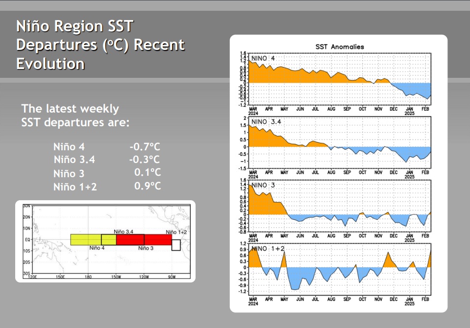
Image from the CPC
The Niño 1+2 region (eastern Pacific) remains the warmest of the 4 ENSO regions at +0.9°C this week, and the ENSO 3 region currently is around +0.1°C. The ENSO regions 3.4 is around -0.3°C and region 4 is at -0.7°C.

Currently we’re
in a very weak La Nina that is quickly transitioning to ENSO neutral. So, we
will likely only stay in La Nina territory for just a couple more months, if
not sooner than that. Even though La Nina will end, it will take a little while
for the atmospheric circulation pattern to adjust, So La Nina like impact could
be felt after La Nina is considered over.
The neutral
conditions look to continue through most of the summer, which could lead to
another active Atlantic tropical season. By the end of the summer, NOAA is predicting
that a swing back to La Nina is quite possible., but the ENSO very well could
stay under neutral conditions. In other words, the spring predictability
barrier does not give us any useful information about next fall and winter at
this time.
Other teleconnections:
Arctic Osculation
(AO)

The AO did briefly
dip into negative territory a couple of days ago, but now it is quickly climbing
back into a positive AO.
A Positive
AO typically has the cold air locked up to our north. When it goes into
negative values, we usually see a push of this cold air spreading south across
the U.S.
North
Atlantic Osculation (NAO)

The NAO is
currently positive and looks to remain positive for the foreseeable future
A positive
NAO helps Strengthen the Jet Stream over the Atlantic. This helps speed up
storm systems moving across the US into the Atlantic. It also helps reduce
blocking.
Eastern
Pacific Oscillation (EPO)
The EPO Is
currently positive, but it looks to turn negative during the first week of
March, this supports the general idea of ridging into Alaska. This would allow
for a better chance for a cross-polar flow into the central and eastern US. This would indicate the first part of March
will be colder than average.
Pacific
North American Pattern (PNA)

The PNA has
been negative a lot this winter. But the PNA did pop positive and it is
currently positive, but, by mid-March the PNA goes negative.
With a negative pattern in place, generally we
see troughing in the West and ridging over the east. So, this is a warm signal.
North
Pacific Osculation (NPO)
We’re in a positive
NPO This will help support cold air being pushed into the Plains. The cold air
dropping south will collide with the warm moist air pushing north out of the
Gulf of America. March and April could
be quite busy in the Southern Plains in terms of severe weather.
The Madden
Julian Oscillation (MJO)

The MJO has left phase 8
and now is in the center (Null). When it was in Phase 8 is a generally colder
phase for this point in the year. It looks to spend a short time in the Null,
before emerging into phase 1. It looks to stay in phase 1 for 7 to 10 days;
then it will once again collapse back into the Null area. Phase 1 is a cold phase in late February into
March. When the MJO is in the Null, it exerts very little influence on the pattern;
so overall control is back in the hands of other teleconnections.
Severe weather this Spring:
The transition from weak La Nina to neutral ENSO conditions will be a big driver this season.
La Nina
tends to see widescale severe weather events, including tornado outbreaks.
Historically, the neutral phase produces less widespread outbreaks, but the
tornadoes seem to have a better chance of being stronger on average. So
localized outbreaks could be a big problem.
The late season chill in the Northeast and the cold Great Lakes will likely limit severe weather in the Northeast this Spring. But when we do warm up during May and especially during June and July, we will see the severe risk in the Northeast become quite active.
The Climate Prediction Center (CPC) 3-month spring temperature and precipitation outlook.


Final
thoughts:
Climatology
is still on our side as far as big snowstorms; but time is starting to run out.
March can see wild swings in the pattern.
We have seen very strong nor’easters during March, the super storm of 1993 is
one example
The negative EPO sets up cold air moving through Canada and into the US. Leading to the idea that the first two weeks of March very well could see colder than average temperatures. It is unclear how long the EPO will remain negative. But the first 10-14 days of the month should be under its influence. When the EPO goes positive, we will likely see a return to at least seasonable temperatures. Across a large part of the CONUS by weeks 3 and 4 of March.
We also
can’t forget the Polar Vortex. I’ve been talking a lot about the PV this winter.
It has been very variable. Having split or stretched 13 times since October. As
I’ve posted in other post on the Blog, we look to see at least one more event
where the PV stretches or maybe even splits. This would signal a good chance
for another arctic blast to invade the central and eastern US.
Another
factor for at least the first half of March to be cold, is with the negative PNA
being delayed in some of the ensembles, that could end up extending the cold
air a little farther into March and at least part of April.
The pattern
during the first half of March is looking interesting. The timeframe of march
4-10 has a shot at having a major storm impacting the East Coast. We look to
have plenty of cold air in place. We should have a trough over the Eastern U.S,
allowing for cold air to set over the Northeast and Middle Atlantic. How far
south that cold air will be is going to be a major factor in where a storm
develops. But a storm is likely to form along that Baroclinic Zone…a divide
between that very cold and very warm air.
Storms can strengthen along a baroclinic zone. How this storm tracks
will depend on the orientation of the trough. If the setup supports it, this
possible storm could come up the Coast and become a big nor’easter. On the
other hand, this could end up ejecting out to sea.
With the
likelihood of several cold air invasions with a general northwest flow. The
pattern is going to be ripe for Clippers to impact our region. These will generally
be light snow events but some could over produce to moderate to locally heavy
snow storms. Lake Ontario still has a lot of open water. So moderate to heavy
lake effect events are still possible as we move through March; those who live
in the lake snowbelts have already seen an epic winter with well above average snowfall.
So, the idea of more lake effect snowstorms possible, it’s not really good news
for many of them.
The CPC shows the western parts of the region near the Great Lakes being slightly above average during March thru May, with the rest of the region being moderately above average. Given how the winterlike temperatures look to linger over the Northeast and Middle-Atlantic into at least the first half of Spring. The CPC could be overly optimistic when it comes to our general overall temperatures.
The CPC
shows a large part of New York State and central and western Pennsylvania
seeing above average precipitation. With the rest of the region having equal
chances for above or below average precipitation. Given
the pattern I’ve discussed, the CPC precipitation Outlook, looks to be generally
in the ballpark in my opinion.
So given the high likelihood of a back-and-forth tug of war between the warm air trying to get into the region and the colder air trying to hang on. It will likely be a slow climb to true spring like conditions over the Northeast into the northern Middle Atlantic. There is a lot of ice over interior bodies of water, rivers and streams. So, Ice jams could be a major issue during March and April. Spring time flooding will also be a big concern, especially for the areas southeast and east of Lake Ontario who have an extremely deep snowpack. Generally, these areas have 5 to 10 feet sitting on the ground, with the likelihood of more snow events over the next few weeks, this could be a historic spring flood season.
Well, that’s about it. I hope you found this informative. Feel free to ask questions and please share this outlook on your social media pages. I don’t know how much longer my weather page will be available on Facebook. So, all y’all passing on the location of the blog site will be a huge help.
Thank you.
Awesome and incredibly detailed as usual
ReplyDeleteThank you!
DeleteIf a slow melt, as will be good.
ReplyDeleteThat would be good
DeleteMore snow would be great. Money in the bank against drought.
ReplyDeleteThe drought map released Thursday showed 1% of the Northeast in extreme drought, 8% in severe drought, 22% in moderate drought, and 36% as abnormally dry compared to 1%, 11%, 23%, and 37%.
DeleteMany areas have frozen ground and so any area under deep snowpack any melting snow will end up as runoff.
https://droughtmonitor.unl.edu/CurrentMap/StateDroughtMonitor.aspx?Northeast
Deletet\Thank you for the forecast, very interesting.
ReplyDeleteYou're welcome
DeleteThank you! I really appreciate these outlooks.
ReplyDeleteYou're welcome
DeleteThank you! I always look forward to your outlooks!
ReplyDeleteYou're welcome
Delete