
With a
possible subtropical system developing in the Caribbean, the system could
become named, it could even become a full born tropical system . I thought I
would post some thoughts I have on the upcoming
2017 Atlantic Hurricane season. This isn't going to go into a lot of
detail. There is still a lot of data that has to come in before I can state how
things look to go. My official tropical outlook will be released most likely at
the end of April.
The first
day of the Atlantic Hurricane Season begins on June 1st. So there is plenty of time to look at the
data and trends.
Even though
there isn't a lot to go by yet, looking at the current Sea Surface Temperatures
(SST)can give us a clue and a few answers.
Here is a
look at SST as of 3/26/2017; in it we can see two things. First, is the
developing El Nino. The second is the cool water west of Africa, and warm
waters off the East Coast of the US.


The analog years I've been looking at are 1951, 1953, 1957, 1972, 1997, and 2015. Number 1 was 1972 and number 2 was 1997.


The Pacific:
Looking at
the tropical Pacific, we see warming in ENSO regions one and two. The current
ENSO neutral conditions look to continue for the rest of Spring, then we will
transition toward El Nino this Summer , and most likely be in an El Nino this
Fall.
History
tells us that El Nino's typically inhibit Atlantic tropical activity. The warm
SST in the Pacific causes the air to rise over the tropical Pacific. Since
weather in the Northern Hemisphere tends to go west to east, that warm rising air in the Pacific sinks over the
Atlantic; this helps stabilizes the atmosphere over the tropical Atlantic. More
in the way of stable air leads to less in the way of thunder storm
activity. El Nino's also tend to cause stronger winds to come off
of Central America, these winds extend into the tropical development zone of
the Atlantic. The winds shear the tops off of developing tropical cyclones,
making it harder for hurricanes to develop. During El Nino years we also tend
to see the Atlantic trade winds blow faster. This causes any thunderstorms that
do develop to move faster , again leading to fewer hurricanes.
It is still
uncertain if El Nino develops, or if it does if the atmosphere will respond
quick enough to make a difference.
The
Atlantic:
We have cool
SSTs west of Africa in the prime development zone. Tropical cyclones need warm SST's in order to
develop. Cooler tropical waters lead to unfavorable hurricane conditions. This
along with a developing El Nino means
long track Cape Verde tropical systems will have a hard time this year.
This time of
year it's hard to make long term predictions. Why? Because this time of year is always a time of transition.
It's
becoming obvious that the upcoming season will have less ACE points than we saw
in 2016.
An article
by Weatherbell's Joe Bastardi was shared to me. Here is a few graphics from
Bastardi's post. These will prove the point I'm making.


In the
images you can see the warmer than normal SST off the Southeast U.S. and
Caribbean
Colder than
normal SST off the Northeast and North Atlantic.
So you have
higher pressures in the north and lower pressures in the tropical development
zone of the Atlantic .
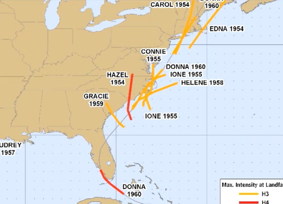
Mean sea
level pressures of the 1950's were higher than normal in the north, normal in
the Atlantic, and lower than normal in the Caribbean.
All of this
causes tropical storms to come close to
the U.S. Southeast Coast and move up the coast.
SST and mean
sea level pressure from 2006 to 2016. This period has seen no official major
hurricane strikes on the East Coast, (But I personally count Sandy as a major
hit, based on her impact).
This year
will have some similarities to last season.
The SST's
are warmer off the East Coast into the Caribbean and Gulf. So, any tropical
systems that do develop will develop on the western side of the Atlantic. The
closer the storms form to the U.S. the greater the odds for landfalling
tropical cyclones on the East and Gulf Coast of the U.S.
My early
thoughts on the upcoming hurricane season
is for a average to slightly below average season. Something similar to1972,
1997, or 2015. So I'm leaning toward 10-12 tropical systems, with 3-4 hurricanes
with 1 major hurricane.
The warmer
waters off the East Coast, would also help tropical systems retain strength or
even intensify as they move up the coast. This would be worrisome, because the
impacts could be similar to what we saw during the 1950's.
That's it for now.
That's it for now.