
Here is a look at my thoughts for the 2023 Spring for the Northeast.
There is no doubt that so far, the 2022-2023 winter has been warm. Vermont, Connecticut, Maine, New Hampshire, Massachusetts, Rhode Island and New Jersey had their warmest January on record. New York State and Pennsylvania, recorded the second-warmest January on Record. Maryland and Delaware also saw one of the warmest January

in the 129-year record. Away from the predominate lake snow belts, most of the Northeast and Middle Atlantic Region are seeing seasonal snowfall accumulations well below average.
The winter has
seen a very active pattern, with frequent storms. There we’re a couple of
snowstorms that brought parts of New York State and New England some decent
snow. But due to the prevalence of warm temperatures, most of the storms were mainly
rain events with some mixing.
Right now,
the question is can we all put away our snow shovels and snowblowers?
Meteorological spring is right around the corner starting on March 1st and
astronomical spring begins on Monday March 20th. Meteorological Spring covers March,
April and May.
What is a
seasonal outlook?
A seasonal
outlook is a broad overview of how the season looks to unfold. It deals with
trends in temperature and precipitation.
It isn’t anything like a weekly weather forecast, it is just a summary
of the season to come. A weekly forecast tries to predict what exactly will
happen over the forecast period.
Seasonal outlooks deal with what is considered average for the
region. A seasonal outlook deals more
with climate science than it does meteorology. To come up with an outlook, I
look at several things, the main ones are using analogues that look at years
where the pattern looks similar to the current season, water temperature
anomalies across the globe, and various teleconnections that have an influence
on weather. Because of this, outlooks
are less accurate than daily and weekly forecast.
Analogues:
Here is the
list of years I’m using as analogues for this spring.
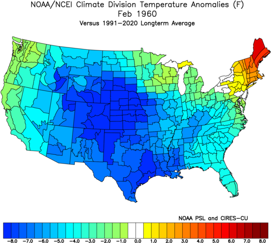
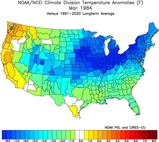
1956, 1960,
and 1984. There are also similarities to the spring of 2018.
Here is how February
averaged for those four years.

Here is how March
and April temperatures averaged for those four years.

Each individual
year averaged like this.
1956


1960


1984


2018


Teleconnections:
The El Nina
Southern Oscillation (ENSO)…
The ENSO
deals with equatorial Pacific water temperatures and air pressure differences
between the western and eastern parts of the equatorial Pacific.
When three-month
temperature anomaly sea-surface temperatures are above average by about 1
degree Fahrenheit or more, El Nino can develop. When temperatures are below
average, La Nina can form. When temperatures are at or near average neither
develops. This is called ENSO-neutral.
Pressure differences
between Darwin and Tahiti, also help indicate if La Nina or El Nino are more
likely. When the pressure is lower than normal in Tahiti and higher than normal
in Darwin, conditions favor the development of El Nino. When the opposite
occurs, La Nina may develop.
La Nina
La Nina has
played a major role, in the weather pattern over the last three years. But the
current La Nina is weakening, and we should quickly transition to ENSO neutral
during the spring. We will likely see the equatorial Pacific transition into an
El Nino over the summer into the fall.


But La Nina will still be an echo during the spring, so the atmosphere will be slower to change, even as the Pacific Temperature anomalies continue to fade.
The Madden
Julian Oscillation (MJO)…
The MJO has
been in the warm phases 4,5, and 6 quite a bit this winter. It moved into the cold
phases a little before Christmas 2022, then it moved into back into the warm
phases for a large part of January. Before dipping into the cold phases for the
end of January into the first bit of February. Then it moved back into phases
4-6. Currently the MJO looks to move back into phases 8 and 1. This would be a
strong hint that we’re going to be cooling off again. As we move into March.
This would tie into what is going on in the stratosphere above the North Pole.

The Arctic
Oscillation (AO) and North Atlantic Oscillation (NAO)…


Both of these are looking to go negative end of February into March.
The Eastern
Pacific Oscillation (EPO) and Western Pacific Oscillation (WPO)…

These too, look to try and turn negative by the beginning of March.
When these four teleconnections are negative, it's a cold signal.
Sudden
Stratospheric Warming (SSW):
An SSW
occurs when the polar stratosphere rapidly warms by as much as around 122 degrees Fahrenheit (50 °C) in just a few days. The rapid increase in the stratospheric temperatures,
disrupts the Polar Vortex which allows the warming temperatures to prorogate down
into the troposphere.
The SSW has
an impact on the Polar Vortex (PV). The
PV is a band of strong winds that circle the Arctic from west to east 10 to 30
miles above the North Pole. When the PV
is strong the polar jet stream stays farther north and has fewer kinks along
it. This keeps the arctic air bottled up over the arctic, keeping mid latitude
temperatures warmer. When we have an SSW, the Polar Vortex breaks down and
weakens. Sometimes during a very strong SSW the PV can even reverse. The weaken
PV can no longer contain the arctic cold, and some of that arctic air can
migrate south into the mid latitudes.


The SSW in
January of 2021, ended up pushing arctic air into the Northeast and Middle Atlantic
Region. 2018 is an analogue year, the strong SSW that occurred in mid-February
of that year, led to a very cold March and April.
Lake Erie
and Lake Ontario water temperatures:
Both lakes water
temperatures are above average for this time of year.


Lake Ontario
ice coverage is also very low. As of 02/13/2023, the ice coverage is less than 5%,


Typically, heavy lake effect snow is rare for both lakes this time of year. But this year, the lack of ice increases the chance for lake effect snow for those areas downwind of both lakes. The general idea of March into April looking to be colder than January and February, means Lake Erie and Lake Ontario will likely have an extended lake snow season.
So, what
about Spring?
Due to the things,
I just mentioned, March into April is looking to be colder and more wintery than
we’ve seen so far for winter 2022-2023.
The spring
of 2018 saw super warmth in February, but then the February powerful SSW, ended
up bringing arctic cold in the 1st part of March, the Cold lasted for
the entire month of March and well into April. March also saw four major
nor'easters at had big impacts in the Northeast, Mid-Atlantic and eastern
Canada. If the current SSW ends up as
strong, it could bring similar conditions to the Northeast and Middle Atlantic
this spring.
The MJO
along with the AO, NAO, EPO, and WPO are all hinting that March will be colder
than January and February.
The
analogues do point toward March and maybe part of April being overall generally
cooler. While it might not get as cold as we saw back in 2018. There is a
chance it could end up being much cooler than many think. I think March will end up below average; this
coolness will likely extend into the first part of April. So, while we will still
be dealing with this overall battle between warm and cold outbreaks. I think the first four to six weeks of Spring will be overall chilly which will
delay the true spring warmth. Even with the cooler start, I do think overall temperatures for the entire Spring will end up above average.
March:
Given the
setup. March is looking to be overall below average when it comes to temperatures
here in the Northeast and northern Middle Atlantic Region. March, at least
right now, is looking to be colder than January and February.
April:
The overall
pattern will remain changeable into mid-April with at least couple of cooler
outbreaks possible. Then the overall pattern should turn milder from mid-April into
May.
May:
Real Spring
should be in place for May.
Snowfall:
Given the active
weather pattern that looks to continue into this Spring. We could see more
snowfall during March and April, then many of us have seen so far this winter. I don’t think we will end up completely erasing
the snowfall deficit for the areas away from the Great Lakes. But the southern
half of the region, could enough snow to make a decent dent into the snowfall deficit.
The snowbelts downwind of Lake Erie and Lake Ontario have seen near average to
above average snowfall this winter. The
lack of ice cover, greatly increases the odds for the snowbelts to end up with snowfall
that is well above average.
So, to answer
that question, I would wait to put away the snow removal equipment for a few
weeks.
Well, that’s
about it.
If the general pattern ends up making a big change, I will release an updated Spring Outlook Mid-March. But for now, this is how I think things will work out.
If you have any questions, comment on here or on the Facebook Pages.
No comments:
Post a Comment
Thank you for taking the time to comment, I will answer as soon as I can.