
The latest Hurricane Season 2019 outlooks:
NOAA, Accuweather, WeatherBell and
most of the other outlets have recently issued or revised their 2019 Atlantic
hurricane outlooks. So I wanted to touch back on the outlook I Issued almost two months ago.
If you haven't read it, you can find it here.
If you haven't read it, you can find it here.
There really hasn't been a major
change from what I said back then. But I have made a few adjustments.
Officially, the Atlantic hurricane
season starts on June 1 and ends November 30.
Here are the calls for this year from
some of the Major outlets.
A major hurricane is a category 3 or
higher with winds of 111mph or greater.

NOAA:
9-15 named storms, 4-8 hurricanes, 2-4
of them major hurricanes.
Accuweather:
12-14 named storms, 5-7 becoming
hurricanes, 2-4 becoming major
hurricanes.
WeatherBell:
10-15 named storms, 4-7 becoming
hurricanes, 1-3 of them major hurricanes. With an ACE of 60-110.
Colorado State University:
13 names storms, 5 become hurricanes, with 2 becoming major
hurricanes.
The Weather Channel:
14 names storms, 7 become hurricanes, with 3 becoming major
hurricanes.
Based on the 30 year average, an average
season consist of 12 named storms, 6 of which become hurricanes, 3 of these
will be major.
2017 and 2018 were very active:
2017:

The season had 17 named storms, 10 of
which became hurricanes, 6 of these became major hurricanes (111+ mph), of those
2 became category 5's ( Irma and Maria).
Three of the major hurricanes made landfall, Harvey in Texas, Irma in
the Caribbean and Southeast U.S. and Maria in the Caribbean, which caused
unbelievable damage and death in Puerto Rico.
4 other tropical systems made a U.S. landfall Cindy in Texas, Emily and
Phillipe in Florida, and Nate in Mississippi.
2018:

The season had 15 named storms, 8 of
which became hurricanes, 2 of these became major hurricanes (111+ mph)
(Florence and Michael). Florence reached
category 4 before weakening to a strong category 1 and making landfall on
Wrightsville Beach North Carolina. She caused catastrophic flooding in the
Carolina's into the Appalachians into West Virginia and Virginia. Michael came over the Keys and made a second
landfall on Mexico Beach Florida. At first Michael was labeled as being a top
end category 4, but this was later upgraded to a category 5 with max winds of
160 mph. Making Michael the 4th category 5 hurricane to ever strike the U.S
mainland.
2019:

Will this year be as active as the previous 2
years? Most likely.
There are many factors but the main ones are:

Sea Surface Temperature (SST) anomalies are running 0.25 to 0.50 degrees Celsius above average in the Eastern Equatorial Pacific and 0.50 to near 1.0 degrees Celsius above average in the Central Equatorial Pacific. Which means we're in a weak to almost moderate El Nino.
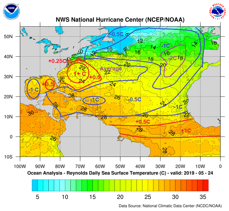
We appear to have entered a negative
(cold) phase of the Atlantic Multi-decadal Oscillation (AMO). The phases of the
AMO last for decades. The cold phase tends to reduce the hurricane risk in the
Atlantic. The Negative AMO is very
visible in the Atlantic. The SST in the
Western Gulf, Caribbean, the main development region are below average. but this could change later in the season.
The SST in the Eastern Gulf and off the East
Coast of the CONUS are above average with the Central Atlantic running average
to slightly above average.
With SST anomalies looking like
this....it's easy to see why this season might be quite a bit less active during June and July. The SST anomalies will change somewhat and warm. If they warm enough that could make a huge difference. Tropical Cyclones love warm water; without it
they will struggle to develop as they move along the main development region in
the Atlantic. The western Atlantic Basin and to an extent the northeastern part of the North Atlantic is warm as well. These areas could see increased tropical cyclone activity.
Because we're in an El Nino there is
going to be a tendency for a lot of moderate to strong vertical wind shear in
the Atlantic Basin. Wind shear is a major factor in stopping tropical cyclones
from forming, or if they form it has a tendency to make them weak. But wind shear along the East Coast and Gulf
could end up average to above average overall.
The El Nino was waning, but now it
seems to be more steady. There is a chance it could intensify a little over the
summer into the fall... But that is not a sure thing. If the El Nino falls apart, that could have big implications later on, making for tropical activity during the 2nd half of the hurricane season .
We will see tropical waves move off
the West Coast of Africa. The question is, will these be able to make the
entire trip across the Atlantic. With
the overall setup looking to be fairly hostile, that could be a tall order.
The biggest danger this season is going to be those storms in the western Atlantic Basin and closer to the CONUS. There is a real danger for tropical development in the eastern Gulf and along and off the East Coast. The Northern Caribbean will have to be watched as well. I think the Bahamas are a big concern for some possible impacts.
The biggest danger this season is going to be those storms in the western Atlantic Basin and closer to the CONUS. There is a real danger for tropical development in the eastern Gulf and along and off the East Coast. The Northern Caribbean will have to be watched as well. I think the Bahamas are a big concern for some possible impacts.
The Eastern Gulf and off the Southeast
Coast will have to be watched closely. Those warmer SST will make close in
development possible. Storms that form close to the Coastline have a greater
chance of making a landfall closer to the top of their strength. They also have
a greater likelihood to be strengthen hurricanes at landfall. Last year we saw what a rapidly intensifying
hurricane is capable of. Not saying we
will see one like Michael, but a Category 1 storm that quickly jumps up a few
categories, is a big deal, as it fools those who thought they would be riding
out a weaker storm.
Accumulated Cyclone Energy (ACE):
I explained what ACE is in my post
from April. But basically the higher the ACE the greater the odds for increased
tropical cyclone activity along with a higher damage potential over the season.
2017 had an ACE of 226, 2018 had an
ACE of 129. And based on the 1981-2010 average, an ACE of 104 is considered average.
When I looked back at similar
patterns. many of the seasons were average to slightly above average. But several of these similar
seasons saw predominate high pressure over the Eastern CONUS. This setup can
lead to weakness developing over the East Coast and Northwest Atlantic. Any
close in systems could try to take advantage of that.
My call for 2019:
Right now, I think the
El Nino will stay fairly weak and weaken as we get closer to the end of hurricane
season. If that happens, the second half of the hurricane season could be more
active than the first part. Ironically the second half of the season is when climatology
says the risk of systems developing in the Western Atlantic closer to the CONUS
is greater. No change in my thoughts about Hawaii and the western Pacific. Rising air in the tropical west Pacific could lead to an overall active season.
12-17 named storms, 4-6 hurricanes, 2-3 of them major. ACE of 110-140
The odds of a landfalling tropical
cyclone on the US is slightly higher than 70%. The odds of a major hurricane making landfall
on the US is around 42%. I think the
U.S. Southeast Coast is at the greatest risk of seeing a landfalling system. I
do see an increased risk of the Mid Atlantic and Northeast being impacted by a
tropical cyclone this season.
Remember every hurricane and every
hurricane season is unique. Tropical Cyclones have a lot of tricks they like to
use. There could be a tendency for tropical cyclones to form outside of the
standard areas of the Atlantic, which will help keep things a bit unpredictable.
Have a plan in place, and be ready to execute
that plan if needed. For help in developing a plan, visit the Weather.gov
website. A below average season, is no
indication that there can't be a major strike to the U.S. All it takes in one
hurricane to impact people's lives and property.
No comments:
Post a Comment
Thank you for taking the time to comment, I will answer as soon as I can.