
With all the severe weather over the last few weeks; I've
been seeing a lot of interest in Severe thunderstorms and especially tornadoes.
So I thought I would answer the questions I've been fielding in a blog post.
This is all a very complex subject. I've tried to keep as much of the technical
and scientific jargon out of it as
possible...when I couldn't...I included a brief explanation on what the term
means......This isn't met to make you
experts...but it should give you a good understanding of what is going on and
how things form.
How
does a thunderstorm form?
A thunderstorm is formed when rising warm air (updraft)
cools as it moves aloft. As the warm air rises, the water vapor cools. The cooling water vapor condenses and forms
clouds. As the updraft of warm air
continues the storm gets taller and taller. At this point the air in the upper
part of the cloud is quite cold. At this time all the dust, dirt and other
things collects moisture and forms precipitation. At some point the
precipitation can no longer stay aloft. The act of the falling precipitation
creates cool downdrafts in the storm. The intermixing of the precipitation with
dust and dirt, forms electrical charges. When these charges dissipate we see
and hear it in the form of lightning.
How
is a rotating (supercell) thunderstorm formed?
To get a rotating thunderstorm (mesocyclone) the
developing condensation of the storm gives off heat to the area around it. This allows it sucks up warm moist air (this
is inflow). The inflow of warm moist air supplies the storm with the energy it
needs to develop. As the thunderstorm
continues to develop the updraft gets stronger . The stronger the updraft the
taller the thunderstorm. The higher the storm the more prone it is to wind
shear.
For a mesocyclone to form you need wind shear ( a change
in wind direction and/or speed with height).
For example, low
level winds coming in from the South, strong midlevel winds Coming in from the
West Southwest, with very strong upper level winds coming out of the Northwest.
Moderate to strong directional and speed shear from the
surface up to around 20,000 feet. is the most important factor in the
development of a supercell. .
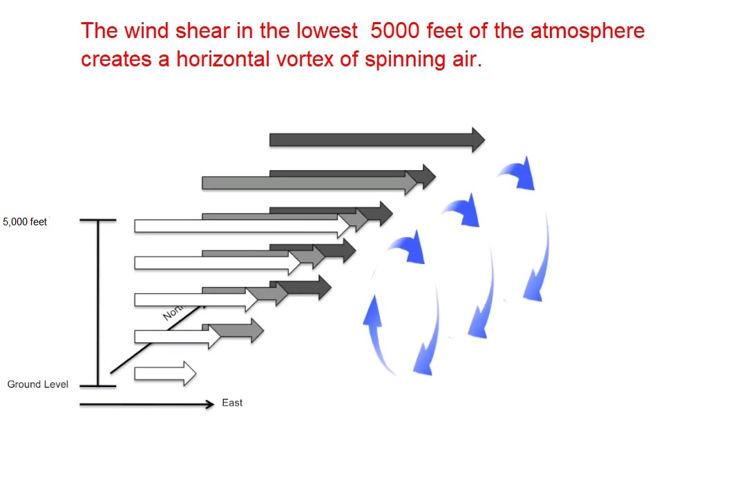
Sometimes as the mechanics
of this process go on, there are spinning
horizontal tubes of air (horizontal vorticity) formed closer to the ground from the
Surface up to around 5,000 feet. This tube of air is drawn up and is aligned
with the flow into the storm's updraft (vertical vorticity). This forces the vertical vortex to start
spinning (Helicity) (Helicity is the measurement of just how much rotation is
wrapping around the updraft). Low pressure in the Mesocyclone's core, makes an
inward pointing gradient force that keeps this inflow vortex spinning in
the midlevel of the storm. This gradient force balances out the fast vertical
vorticity in the midlevel .
As the thunderstorm moves along, the right side will
normally move faster than the air closer to and along the ground, this is where
the updraft begins (This is the wind shear I outlined above). The warm air in
the updraft will enter the storm in the bottom front side of the
thunderstorm. Because of the process, the
rising air will end up in the back top edge of the thunderstorm. The result of
this is the updraft becomes tilted.
The warm moist air mingles with the cool dry air higher
up in the thunderstorm. The wind shear gets the vertical tube of air to spin
faster, as the tube spins faster the tube shrinks in diameter. This increase in
helicity is vital if a supercell is going to form. As the storm gets stronger,
more and more moist air is drawn up, as the thunderstorm gets taller the air
aloft gets colder, and more and more cool dry air is pushed toward the ground;
the tube of air spins and shrinks faster and faster. It is vertical wind shear that makes the
thunderstorm tilt and rotate. A supercell is a thunderstorm with a deep
persistent rotating updraft. Once the
storm becomes saturated with moisture, leading to more and more cloud
formation. It can cause the formation of what is called a wall cloud, but not
always. Most strong to violent tornadoes
are associated with a strong supercell with a wall cloud.
Here are two images that show what is basically going
on.

The tilt of a severe or supercell thunderstorm is
important to its lifecycle. The tilt helps to separate the updraft and the
downdraft from each other. This separation is key to the longevity of the
storm, it keeps the precipitation cooled and more stable air in the downdraft
away from the updraft feeding energy to the supercell, keeping things unstable.
The tilt also plays a big role in the
formation of large and giant hail. The tilt keeps the hail inside the
thunderstorms for a much longer time than a typical garden variety
thunderstorm.

A
little on the tornado:
There is a lot we still don't know about tornadoes, but
there is also a lot that we do know.
While most supercell thunderstorms produce severe
weather, not every supercell will produce a tornado. In fact only around one out
of four supercells will form a tornado. No one is exactly sure why that is the
case.
Tornadoes are rated by the Enhanced Fajita Scale. It goes
from EF0 the weakest to EF5 the strongest. The ratings are assigned after a
damage survey has been completed by the National Weather Service.
For a tornado to form updraft and downdraft are
essential.
When I first started chasing tornadoes. it was clear that
tornadogenesis (tornado development) was highly dependent on the dynamics
inside the storms structure.
There has to be a strong updraft and a source of vertical
vorticity for a tornado to form.
When forecasting tornadoes, you have to look at a
hodograph (This is a chart that shows the speed and direction of vertical wind shear
at different levels of the atmosphere). What you're looking for is a
substantial amount of curvature (a change in wind direction over a horizontal
distance) from the surface up to around
6,500 feet.
The vast majority of the time tornadoes move from
Southwest to Northeast. This has to do with the fact that most tornadoes happen
along a cold front. Most of the time,
the winds ahead of the cold front move from the Southwest to the Northeast.
Like thunderstorms tornadoes also go through a life
cycle. The tornado life cycle is divided into five stages.
1) the whirl
stage...this is when the condensation funnel starts to drop out of the
thunderstorm.
2) the organizing stage..... This is where the
condensation funnel touches the ground, the base solidifies and broadens. It
starts to suck up dirt and dust, making the tornado become darker.
3) the mature stage..... this is when the tornado is at its most
powerful and is very destructive. Many
times this is when the tornado will take on the wedge shape most of us have
heard of. The tornado usually vertical,
and is thick and most of the time appears wider than it is tall.
4) the shrinking stage..... This is when the tornado is
starting to dissipate and weaken. The
tornado will start to tilt and stretch out. A tornado in stage 4 is still dangerous.
5) the decaying stage.... . The tornado will rope out ( takes on a rope
like appearance). Soon after the tornado
will lift and dissipate back into the base of the thunderstorm.
A tornado doesn't have to go through all of these stages;
it can go from stage 2 to stage 5.
Here is an image showing this five stages. I will also include an image from "Tempest Tours" that shows the
various shapes a tornado can take on.


Once the mesocyclone forms, cool dry seeking air is
pulled into the storm and wraps around the back of the mesocyclone. This starts
a process called the Rear Flanking Downdraft (RFD). RFD also plays a huge role
in tornadogenesis. The RFD makes a huge temperature difference between the
outside of the storm and the inside of the storm. All of this greatly increases
local instability, local wind shear, and helicity. This not only strengthens
the mesocyclone, it also vastly increases the odds for tornadogenesis. Once the local wind shear is enhanced and
maintained to be self supporting, tornadoes are possible. RFD is likely the reason for the movement of air
downward, and very well could be the reason for the downward movement of the
outside of the Funnel.
When you see wisp of rain moving left to right it is often a tornado is about form.
When you see wisp of rain moving left to right it is often a tornado is about form.
After all of this a tornado could form. This is when the
condensation funnel will start to drop toward the ground from the thunderstorm.
What
is a condensation funnel?
A condensation funnel is made of water droplets that
extend downward from the base of the thunderstorm. A funnel cloud becomes a tornado when the
condensation funnel makes contact with the ground. It is possible for a condensation funnel to
be invisible most of the way up to the cloud. This is especially true with
tornadoes that have just formed, or in quick spin-ups and short-lived
tornadoes. The dust, dirt, and debris
will be visible a few hundred feet up, then
mid and upper part of the condensation funnel is invisible. Once the tornado is more established, The
rotation and interior mechanics like pressure drop and temperature differences
between the tornado and the air around it, will turn the water vapor in
the condensation funnel into clouds that form the typical visible
tornado we see in videos. But as, I've said before in my storm chasing experience, I've seen evidence that some tornadoes might form from the ground up.....
The size or shape of a funnel is no indication of the
tornadoes strength.
Winds
in a tornado:
The winds in a tornado can be from around 65mph to over
200mph.

There are three things going on that make up the winds in
a tornado. Forward speed, the circulation around the tornado, and the speed of
individual vortices inside the tornado itself.
1) The faster the tornadoes forward speed the stronger
the winds will be on one side of the tornado.
2) The faster the circulation around the tornado the
stronger the winds will be.
3) The stronger the internal vortices (they're like a mini
tornado inside of the larger parent tornado)
The stronger the wind rating for the tornado. These are interrelated
with the circulation of the parent tornado...Not all tornadoes contain these
small vortices. But I do believe most strong and all violent tornadoes contain
them. When present these mini vortices
can be responsible for small areas of incredible damage. But it is also
true, that single vortex tornadoes can
be just as intense as multiple vortex tornadoes.
The
Hook Echo:
When a thunderstorm develops that rotating updraft; it
can have a distinctive radar reflectivity signature called a hook echo. I have
been having quite a few questions on hook echoes. As its name implies it usually looks like a
hook. This hook usually is found in the vicinity of the updraft; typically it is
found in the right rear part of the mesocyclone. Remember doppler radar sees precipitation and
solid objects, not wind.

The hook echo is caused by the rear flank downdraft as it
warps around the backside of the updraft.
What we see on radar is the precipitation that wraps around the mid
level mesocyclone. The hook shape comes from the fact that the mesocyclone
normally is rotating counterclockwise.
The updraft and
inflow notch part of the storm is found inside the hook echo.
The hook on radar indicates the presents of a
mesocyclone. The hook echo is a function of the mesocyclone, and not really the
tornado vortex; it doesn't mean there is a tornado or that a tornado is going
to touchdown. All it means is that there is the potential for a tornado.
Many times ( maybe most of the time) a classic hook echo won't appear on doppler radar. There are many reasons this can happen. The tornado is rain wrapped (the radar can't distinguish the tornado from the surrounding precipitation and mesocyclone, The storm is too far away for the radar to see that kind of detail, the radar beam is shooting over the top of the low level feature, and many others. When chasing tornadoes, I noticed that several times a tornado formed north of the hook. A few formed a good distance north well inside the precipitation shield. There are also signature's that appear on radar that are just a false hook echo. Using radar to find tornadoes involves a lot of guesswork. So for all these reason, when a tornado warning is issued, don't waste time trying to find the tornado on radar, instead find safe shelter.
When looking at
the radar reflectivity scan, the big looking round shape at the end of the
hook, does not equate to a debris signature; it is simply a low level part of
the mesocyclone that is rain wrapped.
The best way to see and find a debris signature using a dual
polarization radar product using correlation coefficient data. The depris signature must be located near the
hook echo. Normally the objects being lofted have low differential reflectivity
values.
There is also something called a Tornado Vortex Signature (TVS); that shows up on a radar velocity
scan. A TVS appears in the mesocyclone in the mid level to upper level of a
mesocyclone. It shows where an intense
area of very concentrated rotation is occurring. While it doesn't mean there is a tornado on
the ground; It does highlight where there is an elevated risk of a tornado occurring.
Here are some radar images from an EF1 in Pennsylvania
from August 22, 2018.


Well that covers all the questions and comments that I
have seen and been getting. I hope it clears up some things.
No comments:
Post a Comment
Thank you for taking the time to comment, I will answer as soon as I can.