
Welcome to Monday.
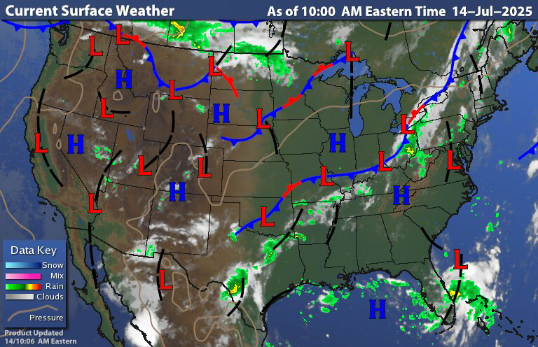
Yesterday as the cold front approached and moved into New York state and Pennsylvania it kicked off widespread thunderstorms. Some of these were severe. Here is a look at the current surface chart showing the position of the cold front now.

As the front continues drop south and east a prefrontal trough will set off showers and thunderstorms this afternoon, as the broken line runs into all that warm air and humid tropical airmass. Radar is showing that some thunderstorms are already forming ahead of that trough. As it was on Sunday some of these storms will be strong too severe. The amount of wind shear is light to moderate. So I think the severe threat will be more isolated in nature. With the amount of water vapor in the air; the risk for a few microburst is there. So thunderstorms will be capable of damaging straight line winds and heavy tropical downpours. Some of the storms could have quite a bit of lightning with them as well. The storm prediction center (SPC) has a Moderate Risk for severe weather over a large part of the region.

Due to the slow moving nature of the storms and the high moisture content in the atmosphere there is a risk for localized flash flooding in some spots. Here is a look at the precipitable moisture content in the atmosphere.


We can see values of 1 1⁄2 to 2 " over a large part of the region, with values over 2" around the I -95 corridor. With all this moisture in the air For those on the I-95 it will be a rough commute this evening. As the storms approach the I95 corridor, New Jersey and Delaware this evening they should be weakening. But the storms will still be capable of very heavy downpours. General rainfall amounts of 1-3 " can be expected with some of the thunderstorms dropping 4 maybe 6" of rain.
For Tuesday New York State and much of New England should remain dry. There will be a slight chance for isolated Showers and thunderstorms over Pennsylvania into the northern Middle Atlantic, but most won't see them. The front will move offshore during the overnight where it will stall to our east and south. Midweek we will be under the influence of the trough then the frontal boundary is going to start to move back north on Wednesday as a warm front bring the chance for scattered rain showers and thunderstorms across Pennsylvania New Jersey Maryland and Delaware. The The front will continue to advance into Thursday. For Thursday through Monday we will be under a warm and humid air mass.. We will have a series of cold fronts dropping down through the region, each day will be capable of scattered showers and thunderstorms. Where is the high moisture content in the air these storms will be capable of very heavy downpours. Some of the storms Thursday into Monday will have the chance to become strong to severe. By Tuesday the fronts should have cleared the humidity out of the region.
Tropical Atlantic
We do have a few tropical waves out over the main development region in the Atlantic But we also have quite a bit of Saharan air dust over the Atlantic as well. The dust dryer and wind shear should keep development over the Atlantic basin into the Caribbean under control But you will have to watch the areas around the Bahamas and into the Gulf of America. As this will be a hotspot due to the time of year when we have stalled frontal boundaries that extend over these regions where something can form and spin up.
We look to see low pressure form off the east coast of southern Georgia and northern Florida north of the Bahamas. This will move across the Florida peninsula into the eastern and north central Gulf of America.
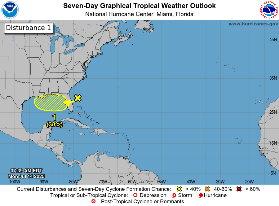
The national hurricane center has the development odd over the next 7 days at 30%. Wind shear will be a big factor for anything to develop and If this gets a name. Regardless of development This will become a heavy rain producer for part of Florida and the Gulf Coast.
The next name on the Atlantic hurricane list is Dexter. Right now The Atlantic hurricane season is running well ahead of average; we typically don't reach the letter D until the Middle of august. We've already had two impactful tropical storms on the US mainland. The first Was the heavy rain over the Texas hill country From the remnants of tropical storm Barry which led to the terrible flooding and loss of life. The second was the heavy rain over the Carolinas from tropical storm Chantal that led to record flooding. So this is the time to develop a safety plan in case your area comes under the influence of a tropical system. As we saw in Texas It doesn't take a hurricane to create a large death toll.
No comments:
Post a Comment
Thank you for taking the time to comment, I will answer as soon as I can.