
This weather pattern With the Bermuda high causing the mid Atlantic ridge that's pumping up the humidity out of the south and the active northern jet keeping systems moving into the region that end of stalling due to the strength of that ridge in the Atlantic continues.


The front of boundary has stalled along the coastal plain, with the prefrontal trough that led to all the rain yesterday is off the coast. We do have a cold front sitting up over Canada.

We still have a lot of humidity in the atmosphere with dew points in the Low to mid 70s South and east of the boundary and dew point in the mid to upper 60s north and west of the boundary. with dew points that high isolated to scattered showers and some thunderstorms are possible. This will be especially true closer to the frontal boundary. Any thunderstorms that form will be slow moving and capable of very heavy rain. The flash flood risk won't be as great as it was yesterday but it is still going to be there.
Tomorrow the frontal boundary is going to be meandering around a little bit creating a risk for some showers and thunderstorms. Thursday will see that cold front approach and drop into the region, This will bring scattered rain showers and thunderstorms, a few of these could be strong to severe with the possibility of damaging winds, heavy downpours and frequent lightning. Right now the severe threat looks pretty limited. Thursday night into Friday this front is also going to stall. Friday will see the risk for scattered thunderstorms and showers along and near the frontal boundary. Those away from the boundary will have the chance for isolated rain showers and thunderstorms.
Saturday will feature the risk for isolated showers and thunderstorms as we will still be under the influence of the frontal boundary. Sunday will feature a greater chance rain showers and thunderstorms. As another front approaches and moves into the region with a few waves of showers and thunderstorms moving along it. Some of these storms will be strong to severe again with the risk for some damaging wind gust heavy rainfall and frequent lightning due to all the humidity in the air. This front will be stalled by Monday with those along the vicinity of the frontal boundary again being at risk for isolated showers and thunderstorms. Tuesday will see this frontal boundary meandering around creating the risk for showers and thunderstorms.
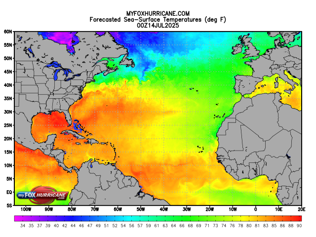
The tropics


The national hurricane center has given this weak elongated area of circulation the designation Invest 93L. With development odds over the next 2 and 7 days at 40%. Wind shear and proximity to the Florida peninsula should keep this in check. But it's still going to be bringing a lot of rain to Florida.
Once 93L Makes it across the Florida peninsula things may change. Sea surface temperatures (SST) In the central and eastern Gulf of America are quite warm for this time of year.

Wind shear over the eastern into northeastern Gulf of America are lighter and more favorable for development.

93L should enter the eastern gulf Tomorrow With the conditions that are in place gradual development is quite possible By Thursday there is a chance that this could be a tropical depression If it develops into a name storm the next name on the list is Dexter. Here is a look at the latest spaghetti model showing the possible track 93L could take.

But regardless of the development this is once again gonna be another heavy rainmaker for the Gulf Coast.
No comments:
Post a Comment
Thank you for taking the time to comment, I will answer as soon as I can.