Today’s
Northeast weather discussion…
High pressure
is starting to push east.
As the ridge
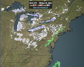
sets up over head, we will see a mix of clouds and sun, with seasonal
temperatures. As a warm front lifts into the region, there will be a risk for a
few rain showers, but most of us should be dry. There will be a chance for a few
snow showers over the higher elevations in the northern part of the region, but
any accumulations will be very light. Later today and tonight, a southern flow,
will allow temperatures to start climbing. So tonight, won’t near as chilly as
last night, with any snow showers turning back to rain.
For Election
Day Tuesday, the front will start to push into Canada, there will be the risk
for some rain showers for those closer to the Canadian Border, with most of the
rest of the region staying dry. Tomorrow the southwest winds will be stronger with gust of 30-35 mph possible,
which will drive temperatures back to well above average for the first part of
November.
Wednesday a
weak moisture starved cold front will slowly move into the region, bringing the
risk for isolated showers. Winds will continue to be breezy with most of the region stay very warm. With the frontal passage, cooler
air will work back into the region. Thursday,
the front will continue to push south across the region. High pressure will build
in behind the front, bringing more in the way of Sun and dry conditions, with
seasonal to slightly above average temperatures through Saturday. Sunday will
see the high pressure start to move away, as another cold front approaches and
drops into the region. The cold front will continue to move across the region on
Monday. With the front will come a chance for scattered rain showers.
For those
looking for a nice soaking widespread rain, unfortunately I don’t see that happening
for the foreseeable future. So, with sporadic rain and breezy conditions, the
drought will continue to worsen and the fire danger will remain high across the
region.
Tropics…
Patty became a tropical storm yesterday, but now she is just a remnant low, heading east at 17 mph, with max sustained winds of 35 mph, and a central pressure of 999 mb. This will be my last mention of Patty.
Tropical
depression 18
Invest 97L
is now a tropical depression, this should become Rafael sometime today. Currently
this is in the southwestern Caribbean and is about 400 miles south east of
Grand Cayman. It is moving north at 9MPH, with winds of 35 mph and a central
pressure of 1003mb. The TD should be near Jamaica later tonight. Then move
close to or over the Cayman Islands Tuesday and Wednesday. With the warm SST
and favorable conditions, this could be a hurricane by the time it reaches the
Caymans and Cuba. For that reason, there are Tropical Storm Warnings up for Jamaica, and
Hurricane Warnings up for the Cayman Islands and western Cuba. This will bring
a swath of 8-14 inches of rain to parts of the Jamaica, Caymans, and western
Cuba, with the high risk of flash flooding and landslides. The Terrain of
western Cuba isn’t as mountainous as eastern Cuba, but it could still disrupt the
circulation at least a bit.
By Thursday this
will be in the Gulf of Mexico, possibly as a hurricane. The general setup is
the same I talked about yesterday. We have high pressure to the north and east,
with a front that is going to be dropping out of the southern Plains. The
timing of this front is key as to where this ends up tracking. If the front is
faster, it could steer this toward Florida. But if the front lags back (which is more likely), this
would track generally toward Louisiana and Texas. It is also possible it could
head toward Mexico. The overall conditions
over the GOM are not ideal. Wind shear and drier air will cause this a big issue,
So I still expect this the weaken over the GOM.
The NHC is watching another area near the northwest Caribbean...could Sara be out there?