A large part of the Northeast has seen their first measurable snowfall for this season.
The
northwest flow is bringing chilly air into the region. We have a lake rain/snow
band on the southeast side of Lake Ontario, bringing snow to the hills south Syracuse
and Mohawk Valley. This is going to generally stay here for the remainder of
the day, before dissipating this evening. We also have a lake effect rain band
coming off of Lake Erie. The radar shows scattered snow showers over northern
Maine, with isolated snow/mix showers over New York State into Vermont and New
Hampshire. The rest of the region is mainly
dry.
Monday and
Tuesday will see temperatures warming, Monday looks to be dry, with rain moving
into the region Monday evening and Tuesday ahead of a cold front. With the
warmer temperatures this will be primarily a rain event, but the higher elevations
of the Adirondacks, Greens and Whites could see some mixing.
Lake Effect
snow will be falling across the Tug Hill into the Adirondacks for Tuesday night
and Wednesday, the rest of the region shouldn’t be too bad
The
Thanksgiving storm:
We have a disturbance off the Northwest Coast, this will move into the Rockies Tuesday and Wednesday, then end up working across the U.S.
The timing
is looking for this to be faster than it was looking last week. So, this will
have big implications for Thanksgiving travel and impacts.
The track is
still in question,
If the track
is across Virginia and the Middle Atlantic then out to sea, other than some mountain
snow across northern New York State and northern New England. The rest of the
region sees little to none.
If the track is across Pennsylvania into New
England, it brings accumulating snow for the northern tier of Pennsylvania, New
York State and northern New England. The snow would track north and east from
early morning Thursday for western Pennsylvania and New York State then into
New England during the afternoon into evening.
Winds will
likely pose an issue for the parades flying large balloons on Thanksgiving.
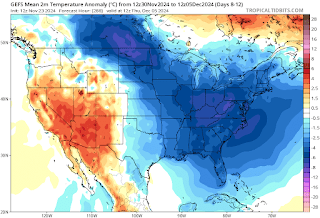
A look at
the longer range.
We have snow
pack building across western Canada. This is important as it helps cold air
transport that comes down from the north. The pattern will stay active. With
high latitude blocking near Greenland and a lot of ridging over the Gulf of Alaska.
The pattern
setting up, allows for cold air near and around the Pole, to get pushed south
into the Plains and East Coast. With a lot of overall troughing in the Midwest
and East Coast.
Here’s a look at the Euro and GFS showing the 500mb height anomalies
Here is the GFS thoughts on the overall pattern. The Euro is looking similar.
So, the end
of November and December will likely be overall cold, with the pattern staying
active there will likely be snowstorm chances.
NOAA’s Climate
Prediction Center 14 day outlook does support this idea.


No comments:
Post a Comment
Thank you for taking the time to comment, I will answer as soon as I can.