Saturday, May 31, 2025

Aurora Borealis

 A large corona mass ejection(CME) yesterday evening has led to the issuance of a G4 Solar storm watch by the Space Weather Prediction Center for tomorrow and Monday.


It could arrive as early as late tomorrow morning or as late as tomorrow evening. The geomagnetic disturbance should be weakening on Tuesday. Depending on the arrival time of the energy from the solar flare the Aurora Borealis (Northern Lights) could be visible across the northern US. They could even be visible as far south as Alabama to North California.


 Many parts of the Northeast  look to have decent sky conditions to possibly see this. But, Canadian  wildfire smoke could be an issue for some along the eastern seaboard. So we will see if we can see them But it's going to depend on timing and sky conditions as always.

The further north you are the better your chance of seeing the Northern Lights. The best way to view the northern lights is to get away from urban light pollution and travel to a location that has a dark northern vantage point.


Friday, May 30, 2025

05/30/2025

 The end is in sight!


Looking at the current surface chart


We can see that weak area of low pressure riding the frontal boundary Over southeast Pennsylvania We can also see low pressure over the Ohio Valley. The western low Is going to be the primary weather maker for us over the weekend.This is gonna cause the development of an upper level low Over Virginia That is going to live north and east At the same time we're gonna see a surface load develop That is going to move over or close to New Jersey then track into southern new England.


Satellite shows Most of the region is socked in under clouds with a lot of lifting out over the Ohio Valley associated with that area of low pressure.


Radar shows most of the region Is dry but we do have isolated rain showers over Long Island and over the Cape. These are associated with weakening area of low pressure. The radar also shows Rain starting to push into southwest Pennsylvania. Most of the region should stay mostly dry today with only a chance for isolated showers here and there.The rain will continue to spread east across southern Pennsylvania today. Then tonight as the surface and upper level lows form. The middle Atlantic region will see widespread showers and thunderstorms develop. Some of these thunderstorms could be strong to severe. The Storm Prediction Center (SPC) has a Slight Risk for severe weather over Maryland and Delaware. With a Marginal Risk over southeast Pennsylvania and southern New Jersey.


Tonight into tomorrow morning, the storm system will be moving north and east Bringing widespread rain showers and some thunderstorms spreading south to north across most of the region. The heaviest rain should fall during the overnight into early Saturday morning.  This will be a quick moving system so by the afternoon even Maine should start to see clearing conditions and showers becoming much more scattered. Interior parts of the region should see a general half an inch to an inch and a half of rainfall. With the risk of having heavy rain at times those closer to the lows track could experience some localized flooding. These areas could end up 1 to 3 inches of rain with locally higher amounts possible.


Sunday will be The best day of the weekend With most of us only having a chance for an isolated shower here and there but parts of new England could see a little bit more in the way of rain during the day By Monday into Tuesday high pressure building overhead providing dry and nice weather.


We've been dealing with a lot of gloomy cool and unsettled weather for most of the Spring here in the northeast; as the pattern has been rather stuck and we've been dealing with several upper level lows up over our region.There have been some nice days but overall it has not been the greatest outdoor weather. But as I've been saying changes are on the way and are almost here.

This weekend we're going to have a deep trough over the Northeast and Middle Atlantic region. Then starting next week we're going to start to See the Southeast Ridge become more dominant in our weather pattern This will lead to more in the way of consistent  Summer weather as warm humid air pushes north out of the Southeast, Gulf of Mexico and Caribbean. Next midweek we will see yet another upper level low form near the Middle  Atlantic. But this one will be much weaker than we've been dealing with. After this, the northern polar jet will push even  further north; allowing some of this warmer and more humid air mass to move further north into New York State and central and northern New England by the second week of June.  The storm track is also going to shift. With the colder air Cooler and dryer air to the north and warm humid air trying to come north, Our region will be more prone to thunderstorms Some of these will be strong to severe as we move further into June. I still don't see a lot of super hot weather over our region during at least the first half of Summer. Those with the greatest chance of seeing more in the way of coolish temperatures will be northern New York State and northern New England. As they will be closer to that temperature boundary.


Thursday, May 29, 2025

05/29/2025

 Here's a look at current conditions.


Looking at the surface chart We can see high pressure up over northern new England giving way to low pressure off the coast in an approaching system from the south and west.


The infrared satellite image shows the system developing over the Tennessee valley.

Today is going to be cool. Radar shows the steady widespread rain is up over New England back into New York State. As this low pressure off the coast continues to live north and east. The rain is going to lessen and become much more isolated To the south and west across the region. A few isolated thunderstorms and rumbles thunder will also be possible today as all this work its way through. Those with the greatest chance of hearing any thunder will be in eastern New York State and especially New England.

During today and tomorrow the system in the Tennessee valley Is going to continue to develop and end up taking over the pattern. As this moves north and east towards our region. We're going to see rain increase.Rain looks to make it into southwest Pennsylvania including Pittsburgh late morning early afternoon on Friday. With rain spreading east during the day. We're going to see this develop into yet another Nor'easter. This will bring widespread rain and breezy conditions to the region Later Friday into the weekend. 

By later Friday We're going to see energy transfer from the primary to another area of developing low pressure over Virginia. The low pressure over Virginia will continue to develop and track north and east towards towards New England. 

Tomorrow rain will develop in southwest Pennsylvania, New Jersey, Maryland, and Delaware during the afternoon into the evening. Rain will reach Southwest Massachusetts and Boston Friday night.  Then move into Maine later Friday night into the overnight. Rain should be widespread for Friday night and Saturday. Rain will be heavy at times. General rainfall amounts of half an inch to an inch and a half are likely but there could be localized higher amounts. Unlike the last Nor'easter this one is going to be fairly progressive, meaning it will be a fast mover. Rain should become much more isolated south to north as the day goes on. Sunday will see the Nor'easter lifting out, leaving lingering rain showers across New York State and New England. Monday we'll see high pressure approach and move in. This will end any lingering rain west to east across the region. For Tuesday the area high pressure remains in control providing tranquil conditions and warming temperatures. On Wednesday the high pressure will start to scoot east but we'll still be dry with temperatures continuing to become a bit milder. Thursday a warm front is going to slide through the region, expect scattered rain showers and isolated thunderstorms.

Once we get into next week the overall pattern is going to Slowly become warmer and dryer with much more sun. 

Tropical

The Atlantic hurricane season starts in 3 days.

While the Atlantic hurricane season hasn't started quite yet. The eastern pacific hurricane season started a couple weeks ago There is currently a tropical depression Just west of Mexico That should become Alvin later today.


In the Atlantic basin, we do have a tropical wave that is moving into the Caribbean. As this continues to work its way west It's going to bring increased rain into the islands of the Caribbean and across northern South America. There are also a couple of very Disorganized Tropical waves to the east across the Atlantic.


Image credit University of Wisconsin Madison.

Looking at the Saharan dust layer (SAL) image. We can see there is quite a bit of dust in the Caribbean and it's  moving into the Gulf of America. There is also a large plume working it's way across the Atlantic. The wind shear chart shows strong wind shear over the Tropical Atlantic as well as the Caribbean into the Gulf of America.

Given that there's a lot of Saharan dust and dry air all over the Atlantic. (As many of us know Saharan dust and dry air inhibits tropical development. There is also quite a bit of wind shear over the Atlantic. Strong wind Shear is also a factor that's repressive for tropical development.) it looks like, the Atlantic hurricane season is going to get off to a slow start. I don't expect to see any real development of these tropical waves for at least the next couple weeks.


Wednesday, May 28, 2025

05/28/2025

 Changes on the way.


Looking at the surface chart And radar We can see we have a warm front lifting north Rain over Pennsylvania and a northern Middle Atlantic region. This is all slowly trying to move north, but we have high pressure sitting on over New England that is acting as a roadblock. The high pressure is slowly gonna give way as that low Virginia and the North Carolina crawls northward as the upper level low over the Great Lakes steers it northward. 


Looking at the infrared satellite image we can see that swirl over the northern Great Lakes which is the ULL and all the lifting in the Middle Atlantic region. The rain will slowly lift north And east  today and tomorrow reaching Maine late in the afternoon or evening on Thursday.

As we had towards friday We are going to see the front slow and end up stalling As this is going on Friday night and Saturday we will see low pressure develop over Virginia. This will move southwest to northeast; heading into New England  on Saturday. For Friday night and Saturday the Region can expect widespread rain and some thunderstorms. Some of these storms could be strong to severe.

Sunday will see the low pressure heading into the Canadian Maritimes. Most of the regions should be relatively dry With only a chance for some isolated showers but those closer to the departing low will have the greatest chance of seeing scattered rain showers on Sunday. High pressure is going to approach Sunday night and stick around overhead Monday into Tuesday Providing quite a bit of sun and and mostly dry conditions.

As we get into the second half of next week the pattern I've been talking about for the last several weeks is going to start taking hold. So by the time we get into the following Week it will feel much more like Summer. I've been talking about this change in the pattern for quite some time So none of this should come as a real surprise. I think the pattern telegraphed very well.


Tuesday, May 27, 2025

05/27/2025

 In spite of the cool and rainy conditions; I hope everyone had a nice Memorial Day weekend.

Over the last 3 months the region has seen a lot of rain.  For the month of May, the vast majority of Y'all have seen a rainfall surplus. But believe it or not, there are a few areas across  northern New York State and Maine that have a  rainfall deficit. In fact  over the last 3 months just about every weekend has seen at least some measurable rain.  


While all the rain has been good for the areas experiencing abnormal dryness and drought conditions; it hasn't been so good for yard work, construction projects and planting of crops.


Yesterday was a little warmer than it was over Saturday and Sunday and the rain was quite isolated So it wasn't too bad.Today we still have high pressure influencing us for. So,  temperatures will be a bit warmer than they were yesterday. We will see clouds increase during the day; but the the good news is most of us will stay completely dry; but I can't rule out a chance for widely isolated light rain showers. 

The high pressure overhead is going to start to push away. This will continue for Wednesday. During the second half of the week we're gonna be dealing with a couple areas of low pressure that will bring rain showers and thunderstorms. 

Looking back at the surface chart we can see low pressure approaching from the Ohio and Tennessee valleys. An upper level low in the northern Plains heading towards the Great Lakes is going to force this area of low pressure to move across our region. The visible satellite shows clouds moving into the region from southwest to northeast. Ahead of all this rain showers will be possible across southwestern Pennsylvania tonight into Wednesday. With the rain, a warm front will lift through on Wednesday, bringing even warmer temperatures across the region. The low pressure will move out of the Great Lakes on Wednesday and Thursday. At the same time, we will see rain moving from southwest to northeast across the region during the overnight and Wednesday, rain looks To move into Maryland Delaware and southern New Jersey during overnight Then it looks to reach  Northeast Pennsylvania Wednesday early to mid morning, Followed by New York cCty. The rain moves into central New York Wednesday afternoon. Rain looks to reach eastern New York state and southwest New England late in the day before sunset . At this point the warm front is going to get hung up and stall out, before continuing to push north and east across New England on Thursday.Rain will likely approach eastern New England Thursday afternoon, then reach Maine  by Thursday evening. 

A cold front is going to be lifting into the region on Thursday this will continue to slide into the region on Friday as it weakens. The front is going to stall out with low pressure developing over Virginia; this will move along the front later Friday into Saturday. This is going to bring widespread rainfall and some thunderstorms to the region, some could be strong to severe.The low pressure will be moving over New England into the Gulf of Maine on Saturday afternoon/evening. On Sunday the low pressure will be pulling into Canada with rain ending  south to north Saturday night into Sunday. During Sunday, southern parts of the region should be mostly dry but the northern parts of New York State and northern into central New England will likely see the rain continue in a more isolated nature for Sunday. High pressure will set up shop on Monday, with only a slight chance for a few very isolated showers. Tuesday is looking to see the high pressure still overhead Providing plenty of sunshine dry conditions


As I've been saying we are gonna warm up But then as we get into the coming weekend and  the 1st week of June We are going to cool back off again averaging well below average. But this really cool air isn't going to last all that long. We're gonna see a pattern flip to where we get a deep trough out west and a predominant Southeast ridge pushing warmer temperatures into our region the end of the 1st week into the second week of June. The storm track is also going to shift north. So, this could increase severe weather risk across the Northeast especially over northern parts of our region. During the 2nd  week of June it should feel like Summer.


Friday, May 23, 2025

05/23/2025

 The Memorial Day weekend is going to be unsettled and cool But we will see things gradually dry out and get better as we head over the next couple of days.


Looking at the surface chart we can see the coastal nor'easter that is weakening as it heads into the gulf of Maine. Attached to this we have an occluded front extending over Pennsylvania and New York. We can also see to the west that dissipating upper level low system Over the lower great lakes. This is going to continue to gradually weaken and dissipate; as the upper level low thats gonna be sitting  between Maine and the Canadian Maritimes develops and takes over. The radar shows that the rain shield is starting to diminish; As all of this continues to evolve. 

As the upper level low near the Canadian maritimes takes over we're going to see several short wave troughs rotate around it, bringing a chance for some rain showers through the region over this weekend into Memorial day Monday. As this is going on a northwest flow is going to continue to keep the cool weather over the region. The combination Of these short waves and the cool  in the Mid levels of the atmosphere Is what is going to keep us unsettled.

Today is going to continue to see the scattered rain showers across the region; the closer you get to new England the more of these scattered rain showers y'all are going to see. winds s are still gonna continue to be a bit gusty, this will especially be true over New England, winds will still be fairly strong over the coastal plain. Tomorrow things will continue to slowly improve west to east as rain coverage over interior areas of the region become more scattered. Again the closer y'all are to the upper level feature the chances for rain increase. Sunday will see this gradual improvement in the pattern continue as rain becomes even more scattered. For memorial day Monday rain will still be around but it will be fairly isolated. So while the weekend won't see It's not gonna be the perfect beach weather As long as you keep an eye on the sky, cookouts especially for Sunday and Monday should be OK.

By Tuesday high pressure will finally set up overhead with lots of sun and  mild temperatures. On Wednesday we're going to see an area of developing low pressure to our south and east push a warm front towards our region. Our chances for rain showers will increase with the passage of the warm front. Behind the warm front temperatures are going to warm even more. We will become under the influence of this low pressure on Thursday; this will increase the chance rain showers and maybe a few isolated thunderstorms, Thursday is also looking to be very mild. On friday a cold front is going to swing through. This is going to bring widespread rain and scattered thunderstorms to the region, some of these thunderstorms are gonna be strong too severe.

Yesterday I touched on the evolving pattern and how it's going to influence our summer here in Northeast and Middle Atlantic. I made the first summer post several weeks ago. Long-term forecasting during the summer is much more difficult than it is during the winter. So things have to be much more vague and general when it comes to the overall pattern. So we can only watch the trends in the teleconnections I mentioned yesterday and what they might be projecting. This summer Is going to depend on the placement of the ridge in The midwest Into the east coast it's also going to depend on the placement of the western Atlantic ridge and Bermuda high. During summer the northern polar jet does pull north, it impacts the Storm track and allow milder southern air to surge north. With the sea surface temperatures along the east coast being as they are, I do think we're gonna see an influence from general high pressure to the north and weakness over the Southeast United States. All of this is also factored into the hurricane outlook I posted several weeks ago. Without rehashing What I posted in these earlier post. While summer here in the Northeast and northern Middle Atlantic has been delayed, it is going to eventually rear its head. 

It's been hard to shake this continuing rollercoaster pattern of upper level lows becoming cut off from the overall flow and just hanging around the great lakes northeast and middle Atlantic I do think this is about to change I think you may have to go through another Of these upper level systems hanging around as we get into June. We're going to see warming temperatures next week so it's gonna feel like summer for a few days. But I don't think it's going to last. As we get into the 1st part of June; I think we're gonna see one more of these upper level features take over our local pattern, bringing cool and  wet conditions. And then after this one things finally clears out  maybe around the time we get into the middle of the second week of June; I think we're gonna set up for more of a summer like pattern, thats gonna see more in the way of overall mild temperatures that have some staying power. I do encourage you to go back and look at the post I've made for the summer pattern. As well as the hurricane outlook I posted. 

I likely won't post anything over the Memorial Day weekend; so my next post unless something drastically changes will be on Tuesday. Have a great and safe Memorial Day weekend. Also remember the true meaning of Memorial Day Is to celebrate and honor those Military and first responders; who gave the ultimate sacrifice, so we can enjoy the freedoms we have!

Thursday, May 22, 2025

05/22/2025


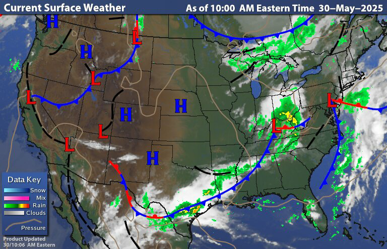
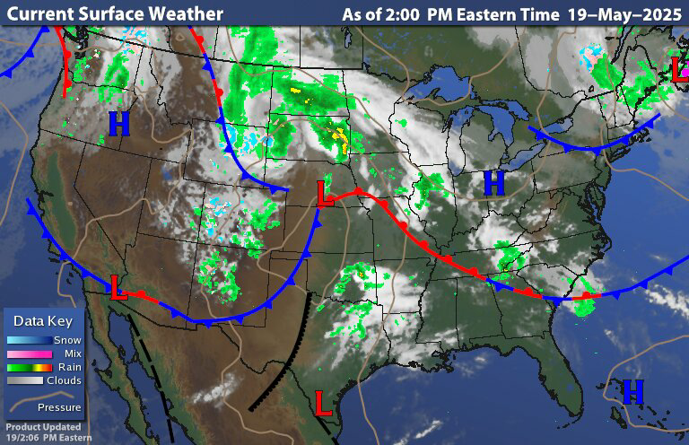
Last evening the primary area of low pressure that is still sitting near the Ohio Valley into the Great Lakes started transferring energy to the coast near the Delmarvia Peninsula. Right now the coastal element Is about to take over as the primary, as the coastal low continues to rapidly intensify we're going to see the rain in the west and the rain along the coast join up and become one. Then we're going to see the rain shield pivot into the interior Northeast bringing everybody widespread rain. 

The low is going to continue developing and become a fairly strong Nor'easter for this time of year. Today into tomorrow it is going to heading towards the Cape and likely over the Cape. During this time we're going to see Widespread rain and gusty winds across the region. Rain could be heavy at times, but the further away from the coast you get the lighter the rain will be. But, in the coastal plain we can expect rain to be heavy, leading to a chance for some localized flooding. Tomorrow the region is still going to see quite a bit of rain with gusty winds continuing. The upper level low and surface low will leave Cape Cod and move into the Gulf of Maine on Friday. Then over the weekend the upper level low is going to be meandering around between Nova Scotia and Maine.

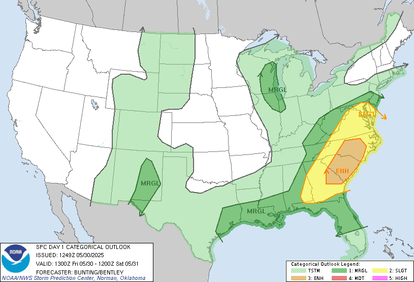
 By the time all of this gets into the Gulf of Maine, it is going to be weakening. As it weakens the precipitation shield is going to be shrinking and becoming more haphazard ,with precipitation rotating in around the upper level feature. So Saturday will feature scattered rain showers across the region. Then for Sunday and Monday the rain should become more isolated. So Sunday and Monday for most of us should be OK to have your outdoor activities; but you will need to keep an eye on the sky and have an umbrella handy in case you get hit by a passing light rain shower. These rain showers should last no more than 15-20 minutes. The closer you are to the upper level low the greater your chances of seeing heavier rain showers. 

Today and Friday is going to be quite cool with temperature running well below average. We will start to warm up over the weekend with Saturday warming up a little bit. And then we turn milder but still below average For Sunday and Monday. Later Tuesday and Wednesday we're going to see low pressure to our south along with an approaching cold front that will reintroduce the chance for some rain showers, especially in southern parts of our region. For Thursday this cold front is going to stall over New York State And Pennsylvania keeping the weather unsettled for our Thursday.


The last couple of days have been very cold. In fact this cold looks to continue for at least the next week to 10 days; as we keep getting plagued by this upper level low pattern; as I said above, temperatures over the next couple days are gonna be running 15°F to as much as 30°F below average for this time of year. Next week we might see temperatures a bit warmer But overall this chill is gonna remain. As I said the other day, we should start to see more in the way of milder temperatures as we get into June. But before we get there we are going to see record low-highs be challenged or even broken.

Medium range pattern change

Believe it or not there is a pattern change that is going on. While the Great Lakes, Northeast into the northern Mid Atlantic are gonna be cold the rest of the US is going to be quite warm. But as I said above We're gonna have to go through this process before our region starts to warm up. The real question is this going to be a long-term persistent pattern that has the Northeast turn into a warm summer ?


Images courtesy of pivotal weather.


Looking at the upper atmosphere pattern, we can see that predominant ridge over western into central Canada. This is influencing the trough in the eastern part of the United States. As we get closer to June and into the 1st part of June there are indications, that the predominant ridge in Canada is gonna start breaking down allowing for a trough to set up over Canada. If this occurs it will encourage ridging here in the eastern United States. But the question is gonna be how prolonged this will be? 

The Quasi  Biennial Oscillation (QBO) is trending negative. When we have an easterly QBO We tend to see a better chance for high latitude blocking. In the equatorial pacific We're in what is called a La Nada. Which is neither El Nino or La Nina. Right now, the nino regions are a chilly neutral. In my summer and hurricane outlooks I said how I thought the ENSO could end up heading back towards La Nina this fall into the winter. But recently there are indications towards an El Nino maybe developing sometime this fall. So right now It could go either way. The Madden Julian Oscillation (MJO) has been stuck in the circle of death for the  last several months; so it hasn't had  a lot of influence on the global pattern. So all this means our summer pattern is going to depend on things like the QBO, Atlantic Oscillation (AO) and the North Atlantic Oscillation (NAO).

Right now I don't see a lot of super heat in the Northeast and Mid Atlantic during June. I think overall we're still going to see generally average to below average temperatures during June. Temperatures during  July and August as a whole, are going to depend On the QBO and the NAO. The QBO looks like it's going to have a predominant trough in the golf of Alaska into the West Coast this summer That would place a ridge over the Plains into the Great Lakes. This would mean a general weakness over the east coast keeping things a bit unsettled.  NAO If it goes negative we could see it enhance the western Atlantic ridge which could lead to some heat here For July into August, This will be especially true for the Middle Atlantic. If this happens we could  have days that get very warm, maybe even hot. But this could go either way. So we could be cool for most of the summer, or we could see a few weeks of heat. We will just have to wait and see how things evolve. Right now this is just a possibility, I still think New York State And new England Is gonna see more coolness than heat over the summer. Southern and eastern Pennsylvania, Maryland, Delaware and New Jersey will have a better chance of seeing some heat this summer. As far as precipitation goes I think generally the northeast Is going to see enough rain to stave off any real drought concerns. But northern Maine could end up seeing some abnormally dry and even drought conditions as we go through the summer. The Middle Atlantic should see ample rain this summer, so they should be fairly wet during June, July and August.


Wednesday, May 21, 2025

Tornado watch

 Click-to-scroll-up Image

Skip Navigation Links weather.gov 
NOAA logo-Select to go to the NOAA homepageNOAA's National Weather Service Select to go to the NWS homepage
Storm Prediction Center
navigation bar left  navigation bar end cap

Local forecast by
"City, St" or "ZIP"

  
USA.gov is the U.S. Government's official Web portal to all Federal, state and local government Web resources and services.

Tornado Watch 310
< Previous WW
 ||||| 
WW0310 Radar
HazardTornadoesEF2+ Tornadoes
LikelihoodModerateLow
Severe Wind65 kt+ Wind
ModerateLow
Severe Hail2"+ Hail
LowVery Low

Note:  The expiration time in the watch graphic is amended if the watch is replaced, cancelled or extended.
Note: Click for Watch Status Reports.
   SEL0

   URGENT - IMMEDIATE BROADCAST REQUESTED
   Tornado Watch Number 310
   NWS Storm Prediction Center Norman OK
   240 PM EDT Wed May 21 2025

   The NWS Storm Prediction Center has issued a

   * Tornado Watch for portions of 
     Eastern Ohio
     Western Pennsylvania
     Far Northern West Virginia

   * Effective this Wednesday afternoon and evening from 240 PM
     until 800 PM EDT.

   * Primary threats include...
     A couple tornadoes possible
     Scattered damaging wind gusts to 65 mph possible
     Isolated large hail events to 1.5 inches in diameter possible

   SUMMARY...Low-topped supercell and related hail/wind and tornado
   potential should focus in a narrow zone regionally near a warm front
   this afternoon until around sunset.

   The tornado watch area is approximately along and 50 statute miles
   east and west of a line from 35 miles north northwest of Pittsburgh
   PA to 30 miles west southwest of Morgantown WV. For a complete
   depiction of the watch see the associated watch outline update
   (WOUS64 KWNS WOU0).

   PRECAUTIONARY/PREPAREDNESS ACTIONS...

   REMEMBER...A Tornado Watch means conditions are favorable for
   tornadoes and severe thunderstorms in and close to the watch
   area. Persons in these areas should be on the lookout for
   threatening weather conditions and listen for later statements
   and possible warnings.

   &&

   AVIATION...Tornadoes and a few severe thunderstorms with hail
   surface and aloft to 1.5 inches. Extreme turbulence and surface wind
   gusts to 55 knots. A few cumulonimbi with maximum tops to 500. Mean
   storm motion vector 23025.

   ...Guyer
Top of Page/Status Messages for this watch/All Current Watches/Forecast Products/Home
Weather Topics:
WatchesMesoscale DiscussionsOutlooksFire WeatherAll ProductsContact Us

NOAA / National Weather Service
National Centers for Environmental Prediction
Storm Prediction Center
120 David L. Boren Blvd.
Norman, OK 73072 U.S.A.
spc.feedback@noaa.gov
Page last modified: May 21, 2025
Disclaimer
Information Quality
Help
Glossary
Privacy Policy
Freedom of Information Act (FOIA)
About Us
Career Opportunities

Tuesday, May 20, 2025

05/20/2025

Today is going to be cool with less of the breeze and should be dry for the vast majority of us. If you're going outside You will need at least a light jacket As temperatures are running 15-20  ° F below average. Last night saw patchy frost for some of the northern areas There was also some snow in the highest elevations. Tonight is going to be another chilly one with a chance for patchy frost over parts of New York State and northern and central New England.

The last several weeks has seen the pattern over the United States be a bit blocky. The pattern has become stuck at times.  And for the most part we've been on the bad side of this block pattern leading to plenty of rain and coolish temperatures. 

Ahead of the system, we're going to see a warm front lift into the region allowing us to warm a bit for Wednesday. Then as the cold front comes through we are going to really cool down for Thursday and Friday, Saturday  we'll see temperatures warm a little but it's still gonna be quite chilly. By Sunday and Monday we should start to warm up but it still looks to be slightly below average for this time of year.


Image courtesy of tropical tidbits

When we look at the surface chart we have the departing system pulling east and another system approaching from the west. As I said yesterday, that upper level low system in the northern Plains is heading towards the Great Lakes and weakening. We're going to see another low develop to the south That will head north and east and then we're going to see an energy transfer from this low to one that's going to form near the Delmarvia Peninsula.


This system has brought a lot of severe weather to the Plains over the last couple of days Today the severe risk is sliding east a bit It's going to be centered around Kentucky Tennessee Alabama and Mississippi, These areas were already hit hard by severe weather and tornadoes A few days ago. 


For Wednesday and Thursday The severe threat over the middle Atlantic and Northeast is very low. As we will be on the cool side of the system. But there is a slight chance for a few storms on the strong side in parts of southwest Pennsylvania.

The rain showers will reach southwest Pennsylvania this evening say 7- 8 PM. Then as we go through the overnight into Wednesday we will see the rain move north and east and become steady then widespread. The rain looks to reach central New York State during midday tomorrow. The rain then looks to reach eastern New York State late afternoon/ early evening, Western new England will likely see the rain begin later in the day/ evening. Rain will reach Eastern new England for places like Boston during the overnight into Thursday morning. and reaching Maine late Thursday into Friday.

The coastal low is going to become a late season Nor'easter. It will continue to develop as it heads towards the Cape on Thursday. And then into the Gulf of Maine on Friday.

Winds will become quite gusty with interior gust of 25-30 miles an hour and closer to the coast and along the coast to 40 to 45 miles an hour, with a chance for higher gust.


We're going to see quite a bit of rain out of this; interior parts of the region can expect half an inch to 2 inches, while those along and near the coastal plain will likely pick up 1-3 inches of rain. As the system develops rain will move west to east across the region; the rain will be heavy at times. So localized flooding will be an issue. 

The weather will stay unsettled during the Memorial Day weekend. The system will be pulling away Saturday. But we will still be under the influence of the upper level feature, that will have rain wrapping around bringing scattered rain showers; that will become more isolated east to west. Then for Sunday most of us should stay dry but there will still be a chance for isolated rain showers. Memorial Day Monday looks to be mostly dry but there are still likely going to be a few isolated showers around the region. Sunday and especially Monday look to see temperatures warm to near to seasonal. So it won't be too bad for Memorial Day cook-outs. Looking ahead this general coolness looks to hang around for most of the rest of the month. But as we head towards and get into June I do expect to see more of a warm up more on a regular basis.

I'm not planning on posting tomorrow. As I will have personal business going on.


Monday, May 19, 2025

05/19/2025

 This is later than I usually like to post but I've been busy! But I didn't forget,  so here's a post that will cover the week ahead.


The surface chart shows high pressure building in and the departing cold front leaving breezy and very cool weather in its wake. Most of the region is dry but we do have rain showers up over parts of northern New York State and northern New England especially New Hampshire and Maine as moisture wraps around that upper level low. Those in the highest elevations of Northern New York State and northern New England could see a bit of snow this evening into tonight, accumulations could be a trace to maybe an inch or so. As the low slowly pulls away Maine will have to deal with a few lingering showers into tomorrow morning.  But then the day should get better; The rest of the region should be a bit less breeze with dry conditions for our Tuesday.

When we look back at the surface chart we can see that system in the Upper Plaines with all that rain that is sliding east and north. This is part of an upper level low that will be heading towards the Great Lakes as we move through the next couple of days. 


The infrared radar image shows this very well. The northern upper level low that is heading towards the Great Lakes is weakening. When we look at the image we can see there is a transfer of energy into the southern Plains. This is going to be the start of a new upper level that will be impacting our region starting Wednesday and lasting at least through Friday.

Tomorrow we're going to see that southern low continue to develop. Ahead of this, the high pressure will start to move east; but still close enough to keep the region dry during the daytime hours. Rain will likely move into southwest Pennsylvania tomorrow night. This rain will advance north and east during the overnight and through Wednesday. Reaching eastern New York state and parts of the northern Mid Atlantic by Wednesday evening. Rain looks to get into Western New England later Wednesday night into Thursday morning. Then rain will work its way into Maine Thursday evening into Friday.

Later Wednesday into Thursday the primary area of low pressure is going to start to transfer its energy towards the coast. Then we're going to see low pressure start to develop near or off the Mid Atlantic coast. This is going to continue to develop into a late season nor'easter type system. This is going to keep us unsettled For the next couple days and through the upcoming Memorial Day weekend; with the high pressure exiting north and east out of the region and the developing low pressure near the coast we are going to be breezy for the end of the week. Wednesday the rain will be moving across the region and become widespread. We can expect widespread rain across the region for Wednesday night and Thursday. Then over the weekend, The coastal nor'easter will be moving into the Gulf of Maine.  For most of us, it won't be raining all the time, but we can expect scattered showers across New York State, Pennsylvania into the Middle Atlantic region. During the same time New England will be dealing with scattered to widespread rain showers. I think by Sunday the showers should become more isolated. For Memorial Day Monday We should see  a mix of clouds and sun, with lots of breaks of sun with most of us staying dry, but there will still be a chance for a few isolated showers.


The rest of this week is going to be cool Then over the weekend into Monday it's going to continue to stay cool In fact when we look at the Climate Prediction Center's (CPCs) 6-10 day temperature outlook; it still looks to be mainly below average for the next Week or two. When I posted on the summer quite a few weeks ago, I said this could be a cool summer, and that certainly looks to be the case.