
This is later than I usually like to post but I've been busy! But I didn't forget, so here's a post that will cover the week ahead.
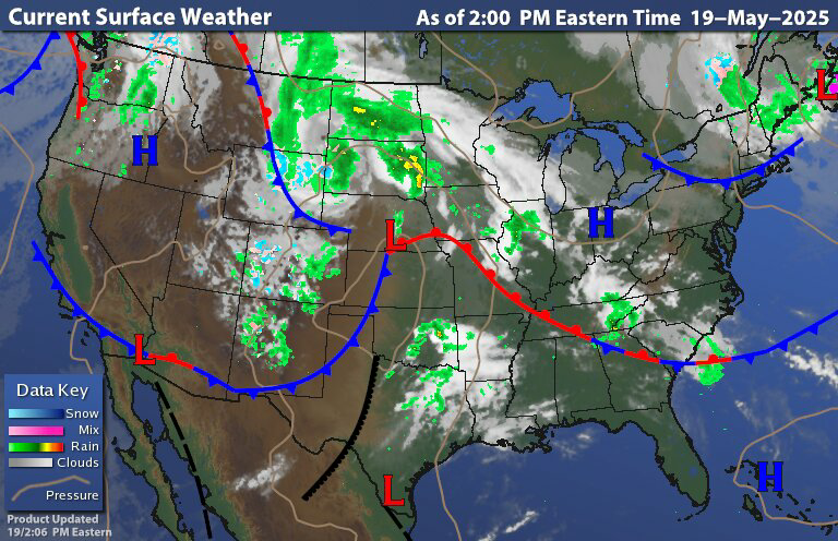
The surface chart shows high pressure building in and the departing cold front leaving breezy and very cool weather in its wake. Most of the region is dry but we do have rain showers up over parts of northern New York State and northern New England especially New Hampshire and Maine as moisture wraps around that upper level low. Those in the highest elevations of Northern New York State and northern New England could see a bit of snow this evening into tonight, accumulations could be a trace to maybe an inch or so. As the low slowly pulls away Maine will have to deal with a few lingering showers into tomorrow morning. But then the day should get better; The rest of the region should be a bit less breeze with dry conditions for our Tuesday.
When we look back at the surface chart we can see that system in the Upper Plaines with all that rain that is sliding east and north. This is part of an upper level low that will be heading towards the Great Lakes as we move through the next couple of days.

The infrared radar image shows this very well. The northern upper level low that is heading towards the Great Lakes is weakening. When we look at the image we can see there is a transfer of energy into the southern Plains. This is going to be the start of a new upper level that will be impacting our region starting Wednesday and lasting at least through Friday.
Tomorrow we're going to see that southern low continue to develop. Ahead of this, the high pressure will start to move east; but still close enough to keep the region dry during the daytime hours. Rain will likely move into southwest Pennsylvania tomorrow night. This rain will advance north and east during the overnight and through Wednesday. Reaching eastern New York state and parts of the northern Mid Atlantic by Wednesday evening. Rain looks to get into Western New England later Wednesday night into Thursday morning. Then rain will work its way into Maine Thursday evening into Friday.
Later Wednesday into Thursday the primary area of low pressure is going to start to transfer its energy towards the coast. Then we're going to see low pressure start to develop near or off the Mid Atlantic coast. This is going to continue to develop into a late season nor'easter type system. This is going to keep us unsettled For the next couple days and through the upcoming Memorial Day weekend; with the high pressure exiting north and east out of the region and the developing low pressure near the coast we are going to be breezy for the end of the week. Wednesday the rain will be moving across the region and become widespread. We can expect widespread rain across the region for Wednesday night and Thursday. Then over the weekend, The coastal nor'easter will be moving into the Gulf of Maine. For most of us, it won't be raining all the time, but we can expect scattered showers across New York State, Pennsylvania into the Middle Atlantic region. During the same time New England will be dealing with scattered to widespread rain showers. I think by Sunday the showers should become more isolated. For Memorial Day Monday We should see a mix of clouds and sun, with lots of breaks of sun with most of us staying dry, but there will still be a chance for a few isolated showers.

The rest of this week is going to be cool Then over the weekend into Monday it's going to continue to stay cool In fact when we look at the Climate Prediction Center's (CPCs) 6-10 day temperature outlook; it still looks to be mainly below average for the next Week or two. When I posted on the summer quite a few weeks ago, I said this could be a cool summer, and that certainly looks to be the case.
Thank you. Have a great week
ReplyDeleteThanks.
ReplyDeleteI Love Nor' Easter’s,the
ReplyDeleteBigger the Better but NOT in May.