
Post on the next few days drought conditions and touch on the tropics.
The surface chart shows the area of low pressure in Canada dragging that cold front approaching the region.

Out ahead of the front we have hot and humid conditions. Radar is showing scattered rain showers and thunderstorms developing over New York State into New England. These are associated with that trough sitting over New York State into Pennsylvania. The severe storms that were over Long Island have pushed east.

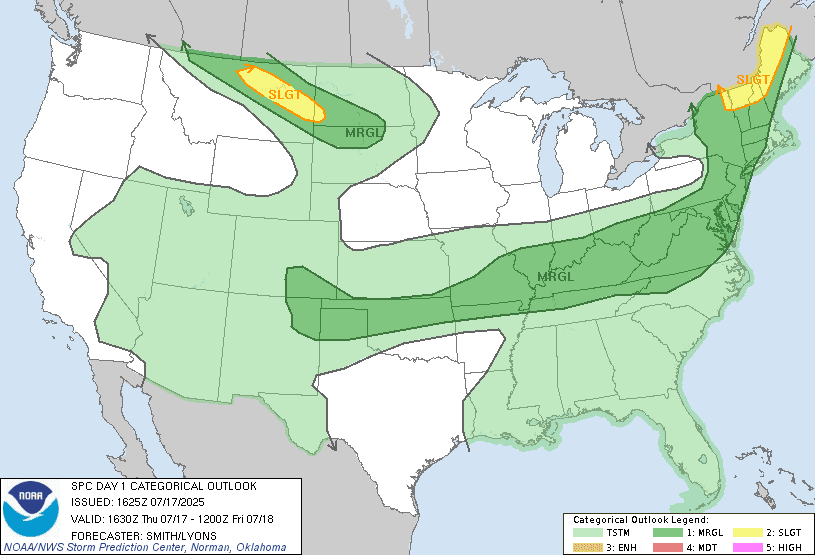
As the cold front gets closer another prefrontal trough will come through that will kick off some rain showers and thunderstorms. Across Pennsylvania into Maryland, Delaware, New Jersey and the I-95 corridor the showers and thunderstorms should be fairly isolated, But later in the day far southern Pennsylvania into Maryland and Delaware could see a little bit more in the way of showers and thunderstorms. But I really don't think you're going to be very wide spread. For today and to this evening up over New York State into northern and central New England closer to the area of low pressure we will see scattered showers and thunderstorms. Some of the thunderstorms this afternoon and evening will be strong to severe With the risk for damaging straight line winds, some small hail, heavy downpours and frequent lightning. The tornado risk is very low but not zero. The storm prediction center has a Marginal Risk For severe weather over the eastern half of New York state Pennsylvania into new England and Maryland, Delaware and New Jersey. I don't know if I agree with the Marginal Risk across much of Pennsylvania into the middle Atlantic. the Parameters don't look like they support it. But that's the SPCS' call not mine. Those with the greatest chance of seeing any severe weather Will be up over New York State and New England where there is more lift associated with the low pressure in Canada. The risk for more in the way of widespread severe storms will be across northern New England where the SPC has a Slight Risk for severe weather.
Tomorrow high pressure moves in and the front will be sagged to our south. A northwest flow will bring in cooler temperatures and much lower humidity.
Friday night another system will be approaching, with increasing clouds west to east. The Stall front will start to move north as a warm front. It will move into western Pennsylvania on Saturday. For places like Pittsburgh rain will probably Start mid to late morning. Western New York state a few showers move in during Saturday afternoon. This will slowly be moving across the region reaching central parts of New York State and Pennsylvania in the evening. Temperatures and humidity levels slowly increasing with the frontal passage but the vast majority of the region should stay comfortable. The trailing cold front will move into western parts of Pennsylvania Saturday night. Temperatures and humidity will be increasing a bit ahead of the front Sunday. During the day into the evening scattered rain showers and thunderstorms will be around.
Monday through a large part of the coming week is looking to be fairly decent. As high pressure sets up with seasonal to slightly below average temperatures and low humidity. The region should be dry for For Monday through Wednesday.
The drought monitor.
All the rain Over the last several weeks has the vast majority of the region drought free. With only a few areas experiencing abnormally dry conditions. There is only 1 area of moderate drought in southeast Massachusetts. With all the rain in the forecast These conditions should continue to improve.

The tropics.
Invest 93L moved across the Florida Peninsula into the Panhandle yesterday. Today it is tracking along the northern Gulf Coast

93L is in a low shear environment but it is been dealing with some dry air and it is unclear if it will emerge over open water long enough for better development odds. Right now chances of this developing into a tropical depression or storm is fairly low. Guidance suggest this could track a little further north then the current model projection. But, the national hurricane center is still giving it 2 day and 7 day development odds of 30%.

Widespread flooding will be possible across the Florida Panhandle through Louisiana where general rainfall amounts Of 5-8 " of rain with localized amounts of around 15" will be possible. This will especially be true for places in Louisiana. Southeast Texas could also end up with quite a bit of rain. Here is a look at the latest spaghetti model showing the possible tracks 93L could take.

No comments:
Post a Comment
Thank you for taking the time to comment, I will answer as soon as I can.