Daily
forecast discussion…
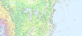
That weak disturbance that was in the southern Plains, is moving north and east and is heading into the great Lakes, there is also a piece that broke off the disturbance that is passing just to our south.
High
pressure is supplying plenty of sun with temperatures a little warmer than
yesterday the surface chart and satellite imagery is showing, a weak
disturbance is approaching this is heading into the great Lakes, there is also
a piece that broke off the disturbance that is passing just to our south.
Clouds will
be on the increase, then rain showers will develop late today, these will move
north and east tonight into Saturday. We will have a little cold air wedged in,
that will allow for a bit of freezing drizzle/rain. The ice won’t be heavy but some could see upwards
of tenth of an inch, especially in the higher elevations and those sheltered
valley locations. It doesn’t take much ice to cause issues, so the NWS has issued
Winter Weather Advisories for parts of the region. Temperatures will be warming
so the ice will change over to plain rain. The 2nd piece of this
system will pass just to our west on Sunday, this will allow for more in the
way of widespread rain for the region for Sunday into Monday, there will be a
southern flow that will usher in much warmer temperatures for Sunday. These mild
temperatures will hang round through Tuesday.
With the
rain and snowmelt, flooding will be a concern for some areas.
Most of
Monday into Tuesday looks to be dry, then another system will approach bringing
rain showers later afternoon these will be move west to east, by the time for
New Years Eve celebrations we can expect rain to be an issue. The rain will go into New Year’s Day, then
cold air is going to wrap in behind the system, changing rain over to a mix and
some snow on the backside for parts of New York State and northern Pennsylvania
this will be especially true for the higher elevations. We can also expect lake
effect snow downwind of the Great Lakes. All of this will move east during the
day. Bringing a mix and some snow to northern parts of New England. Areas south of this should see just rain that
will be winding down during the day.
High pressure
will be building in behind bringing in colder weather. The weather will be
unsettled for Friday into next weekend.


Thank you.
ReplyDeleteYou're welcome Karen.
DeleteThank you
ReplyDeleteYou're welcome
DeleteLooking fr to your 2025 analyses!
ReplyDeleteI've been posting on the pattern for awhile now
Deletefollowing it, but not comprehending some, so I get the AHA moment later when it actually happens or you explain what variable changed it. Great work
DeleteThank you and wishing you a great weekend.
ReplyDeleteyou're welcome
Delete