
Who saw the total lunar eclipse?


The surface
chart shows, high pressure is in control with our developing storm in the
central CONUS. This is going to lead to a big severe outbreak for the Mississippi
Valley, eastward into the Lower Ohio and Tennessee Valleys later this afternoon
into Saturday morning. For our region, satellite and radar show we have plenty
of sunshine and dry conditions across the region. Ahead
of the western system, southwest winds will be driving mild temperatures today.
Tonight is going to stay mild and dry.
Saturday is
going to see that western storm slowly approaches the Great Lakes. Temperatures
are going to continue to climb. Clouds will be increasing as a warm front lift
into the region. As the warm front
advances, southwest Pennsylvania, should see isolated showers develop late
morning to early afternoon. As the warm
front move through, the isolated rain showers will advance with it across the
region. The southern flow is going to
increase on Saturday, so winds will be getting gusty. Thunderstorms will be approaching western
parts of the region, some of these could be strong across western Pennsylvania
and western New York State.


Saturday
night and through Sunday the strong cold front will approach and move through. Rain
across the region will move west to east and become steady and widespread.
Winds will also become very gusty, with winds of 20 – 30 mph with gusty of
40-50 mph possible. Northern areas could see some embedded thunderstorms, the
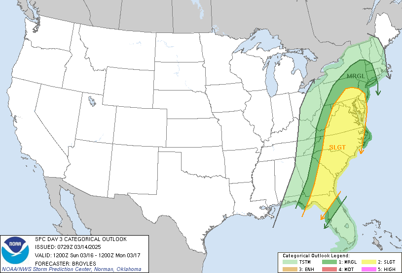
rest of the region will have a chance for strong to severe thunderstorms, this
will be especially true for Pennsylvania, Maryland, Delaware into New
Jersey. Sunday is going to be even milder
than Saturday, general rainfall amounts of 0.50 to 1.0 inches can be expected,
with those who see stronger thunderstorms having a chance for higher amounts. Winds will be the main danger with these
thunderstorms, but hail and even an isolated tornado is possible.
Monday
morning the rain will be over New England and pushing east. Rain should be pushing
offshore during the afternoon. High
pressure will move into the region, with temperatures turning back to seasonal
cool. The high pressure will stay overhead for Tuesday and Wednesday, temperatures
will be quite mild as well. Thursday another cold front will approach,
bringing widespread rain, windy conditions and some thunderstorms, ahead of the
front temperatures will become very mild. For Friday into Saturday colder air will be
moving in, rain will be changing over to snow west to east across part of
Pennsylvania, New York State and central and northern New England, some
accumulation is likely especially for the higher elevations.

Not liking all this warm weather. I'm afraid Summer will be unbearable again.
ReplyDelete