
Here is a look at this current surface chart


We can see low pressure Moving through the great lakes with an attached warm front over Pennsylvania that is moving north and east across the region. We also have a trailing cold front Over the great lakes back into the Midwest.
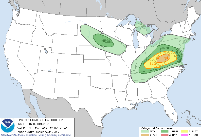
As the warm front lifts through we will see Temperatures warm up Along with scattered showers and thunderstorms develop first across Southwest Pennsylvania and then move across the rest of the region tonight into tomorrow morning. Some of the storms could be strong too severe Especially over Pennsylvania Into the northern mid Atlantic. The storm prediction center (SPC) has a Marginal risk For severe storms Across southwest Pennsylvania, They also have a slight Risk and a Enhanced Risk for severe weather along and south of the Mason Dixon line.
Tomorrow a cold front will swing through, it won't be a complete washout But the front will bring hit and miss rain showers and some thunderstorms. Rain could be moderate to perhaps heavy at times. The trailing secondary cold front will move through the region later in the day into Wednesday, with the front winds will become gusty with gust of 30-40 miles per hour possible, as the air cools off rain showers will change over to snow showers for elevations 1,500' and higher. For the Poconos and Catskills a dusting to an " or so of snow will be possible. The area near around the Finger Lakes Could see 3-4 inches. For northern parts of the region A few inches of snow will be possible. The Adirondacks Greens and Whites Could see 3-6 inches of snow. Those downwind of lake Ontario on the tug hill Could see a bit more Due to lake enhancement. Winds on Wednesday Will continue to be quite gusty.
Thank you.
ReplyDeleteYou're welcome
DeleteThank you Rebbeca
ReplyDeleteYou're welcome
DeleteThank you
ReplyDeleteYou are welcome
DeleteThank you.
ReplyDeleteYou're welcome
DeleteThank you.
ReplyDeleteYou're welcome
Delete